MyTopo
Cape Henry Virginia US Topo Map
Couldn't load pickup availability
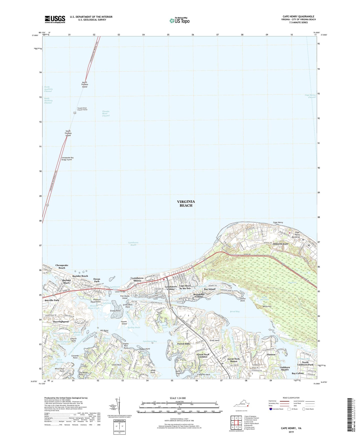
2022 topographic map quadrangle Cape Henry in the state of Virginia. Scale: 1:24000. Based on the newly updated USGS 7.5' US Topo map series, this map is in the following counties: Virginia Beach (city). The map contains contour data, water features, and other items you are used to seeing on USGS maps, but also has updated roads and other features. This is the next generation of topographic maps. Printed on high-quality waterproof paper with UV fade-resistant inks.
Quads adjacent to this one:
West: Little Creek
Northwest: East of Hampton
North: Chesapeake Channel
Northeast: Fishermans Island
East: North Virginia Beach
Southeast: Virginia Beach
South: Princess Anne
Southwest: Kempsville
This map covers the same area as the classic USGS quad with code o36076h1.
Contains the following named places: Adam Thoroughgood House, Alanton, Alanton Elementary School, Anchor Christian School, Avery Island, Battery Alexander C M Pennington, Bay Colony, Bay Island, Bay Lake United Methodist Church, Baylake Beach, Baylake Pines, Bayville, Bayville Creek, Bayville Farms Park, Bayville Golf Course, Bayville Park, Broad Bay, Broad Bay Colony, Brock Cove, Cape Henry, Cape Henry Collegiate School, Cape Henry Lighthouse, Cape Henry Memorial, Cape Henry Memorial Cross, Cape Henry Plaza Shopping Center, Cape Henry Post Office, Cape Henry Village, Cape Story by the Sea, Caraway Point, Carter Point, Chesapeake Beach, Chesapeake Channel, Church Point, Crab Creek, Dey Cove, Dix Creek, Eagles Nest Point, Eastern Branch Lynnhaven River, First Landing Chapel, First Landing State Park, Fish House Island, Forest Hills, Fort Story, Fort Story Fire and Emergency Services, Fort Story Post Office, Fort Story Station Virginia Beach Post Office, Francis Asbury Church, Frank W Cox High School, Grassy Point, Great Neck, Great Neck Dam, Great Neck Estates, Great Neck Lake, Great Neck Manor, Great Neck Middle School, Great Neck Plaza Shopping Center, Great Neck Point, Great Neck School, Great Neck Village Shopping Center, High Dune Trail, Hill Point, Humes Island, John B Dey Elementary School, Keeling Cove, Keeling Drain, Lagoon Trail, Lake Charles, Lake Joyce, Lesner Bridge, Linkhorn Bay, Linkhorn Shores, Little Neck, Log House Point, Long Creek, Long Creek Trail, Lynnhaven Bay, Lynnhaven Colony, Lynnhaven Colony Congregational Church, Lynnhaven Inlet, Lynnhaven River, Lynnhaven Roads, Lynnhaven Shores, Main Trail, Mapps Point, Mill Dam Creek, New Cape Henry Lighthouse, Nike Site N-25C, Nike Site N-25L, North Auxiliary Channel, North Linkhorn Park, North Thimble Island, Ocean Park, Ocean Park Rescue Squad, Old Cape Henry Lighthouse, Osmanthus Trail, Our Saviors Lutheran Church, Pleasure House Creek, Pleasure House Point, Poorhouse Cove, Saint Theresa Chapel, Sandy Point, South Auxiliary Channel, South Thimble Island, Spring Branch Community Church, Stratford Preschool, Sunstates Shopping Center, The Desert, The Narrows, Thimble Shoal Channel Tunnel, Thoroughgood Cove, Thoroughgood Dam, Traditions Golf Club at Broad Bay, Virginia Beach Country Day School, Virginia Beach Fire Department Station 1 First Landing, Virginia Beach Volunteer Emergency Medical Services Station 1 Ocean Park Rescue Squad, Virginia Beach Volunteer Emergency Medical Services Station 22 First Landing, Western Branch Lynnhaven River, Westminster Canterbury on Chesapeake Bay Nursing Home, White Hill, White Hill Lake, White Hill Lake Trail, Witch Duck Bay, Y M C A Camp, ZIP Code: 23459