MyTopo
Saint Paul Virginia US Topo Map
Couldn't load pickup availability
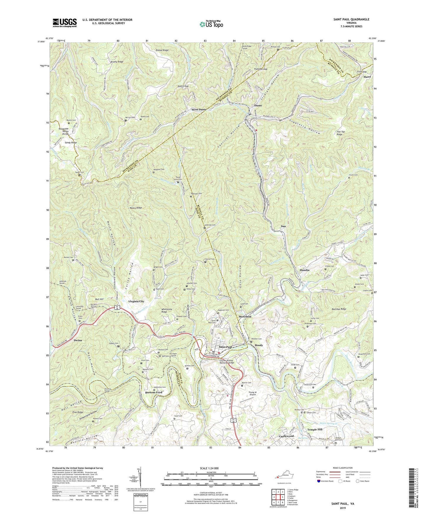
2022 topographic map quadrangle Saint Paul in the state of Virginia. Scale: 1:24000. Based on the newly updated USGS 7.5' US Topo map series, this map is in the following counties: Russell, Wise, Dickenson. The map contains contour data, water features, and other items you are used to seeing on USGS maps, but also has updated roads and other features. This is the next generation of topographic maps. Printed on high-quality waterproof paper with UV fade-resistant inks.
Quads adjacent to this one:
West: Coeburn
Northwest: Caney Ridge
North: Nora
Northeast: Duty
East: Carbo
Southeast: Hansonville
South: Moll Creek
Southwest: Dungannon
This map covers the same area as the classic USGS quad with code o36082h3.
Contains the following named places: Austin Gap, Banner Cemetery, Bear Wallow Hollow, Bee Branch, Bellamy Cemetery, Bickley Cemetery, Bickley Mill, Big Branch, Big Bull Tunnel, Big Spring, Big Spring Branch, Boody, Bull Hill, Bull Hill School, Burton Cemetery, Burtons Ford, Bush Cemetery, Caledonia Hollow, Castle Run, Castle Siding, Castlewood, Castlewood Census Designated Place, Castlewood Fire and Rescue Main Station, Chafin Cemetery, Charles Bickley Memorial Bridge, Cherry Knob School, Cigarette Hollow, Couch Cemetery, Craigen Tunnel, Crooked Branch, Curley Hollow, Dante, Dante Census Designated Place, Dante Elementary School, Dante High School, Dante Post Office, Dante Rescue Squad Main Station, Dante Rescue Squad Substation, Dante Volunteer Fire Department Station 37, Dickenson Cemetery, Dingus Memorial Church, Dismal Ridge, Dorado, Dwina, Dwina Hollow, Dwina School, Dwina Station, Dye Cemetery, Evans Cemetery, Fields Cemetery, Flat Top Ridge, Flint Gap, Flying W Airport, Fraley Cemetery, Gibson Cemetery, Glovier Cemetery, Gose Cemetery, Gose Hollow, Gose School, Granny Branch, Gravel Lick Church, Gravel Lick Creek, Grindstone Branch, Hall Hollow, Hamlin, Hamlin Branch, Hamlin Church, Hardy Hollow, Hasn Hollow, Hazel, Hazel School, Hileman Cemetery, Holbrook Cemetery, Holbrook Tunnel, Honey Branch, Honeycomb Branch, Jessee Cemetery, John, Kilgore Creek, Kimberland Hollow, Laurel Branch, Left Fork Lick Creek, Lick Creek, Lick Creek School, Little Bull Tunnel, Lonesome, Low Gap, Lucas Cemetery, Maize Hollow, McCoy Cemetery, McCoy Chapel, Meade Creek, Meadows Branch, Meadows Cemetery, Morefield, Moretz Cemetery, Moses Branch, Nancy Ridge, Phillips Cemetery, Plaster Cemetery, Powers Cemetery, Price Cemetery, Primitive Church, Right Fork Lick Creek, Riverside Industrial Park, Robinette Branch, Robinette Cemetery, Robinson Cemetery, Rural, Russell Creek, Russian Branch, Saint Paul, Saint Paul Cemetery, Saint Paul Elementary School, Saint Paul High School, Saint Paul Police Department, Saint Paul Post Office, Saint Paul Volunteer Fire Department, Sandy Ridge Church, Sandy Ridge Tunnel, Saylor Cemetery, Selfe Cemetery, Seven Spring Creek, Shannon Tunnel, Skeen Cemetery, Squirrel Hollow, Stallard Memorial Church, Straight Hollow, Sun, Talbert Cemetery, Temple Hill, Temple Hill Cemetery, Temple Hill High School, Temple Hill School, Three Forks Cemetery, Town of Saint Paul, Trammel, Trammel Gap, Virginia City, Wells Chapel, West Dante, Wheeler Cemetery, Whetstone Ridge, Willey Cemetery, Wright Cemetery, Zion Church, ZIP Code: 24283