MyTopo
Charlottesville East Virginia US Topo Map
Couldn't load pickup availability
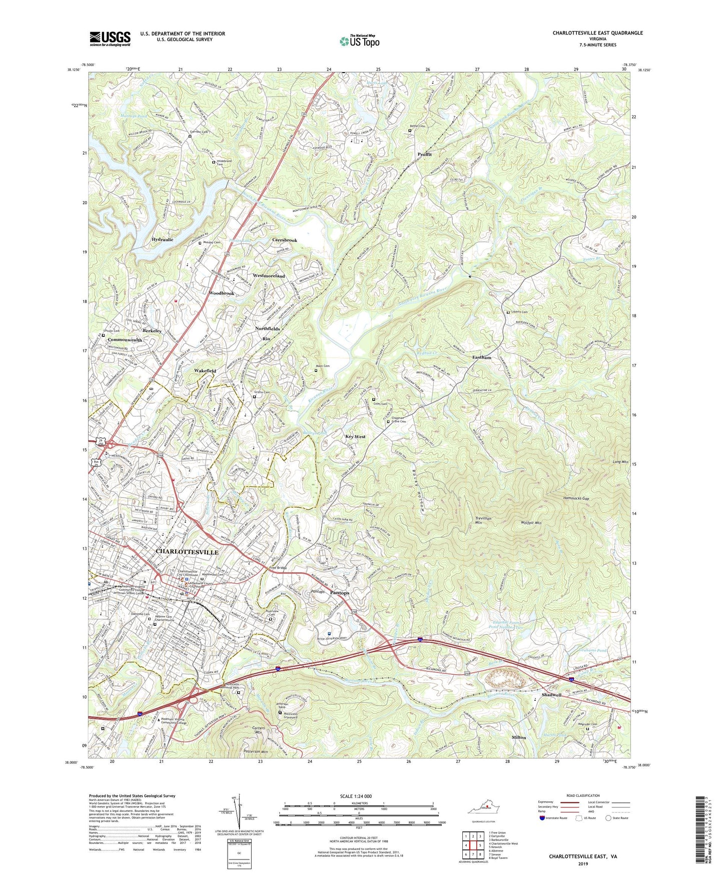
2019 topographic map quadrangle Charlottesville East in the state of Virginia. Scale: 1:24000. Based on the newly updated USGS 7.5' US Topo map series, this map is in the following counties: Albemarle, Charlottesville (city). The map contains contour data, water features, and other items you are used to seeing on USGS maps, but also has updated roads and other features. This is the next generation of topographic maps. Printed on high-quality waterproof paper with UV fade-resistant inks.
Quads adjacent to this one:
West: Charlottesville West
Northwest: Free Union
North: Earlysville
Northeast: Barboursville
East: Keswick
Southeast: Boyd Tavern
South: Simeon
Southwest: Alberene
Contains the following named places: Agnor - Hurt Elementary School, Albemarle County Health Department, Albemarle Historic District, Albemarle Square Shopping Center, Albemarle Training School, Ardwood, Ashcroft, Baileys Dam, Baileys Pond, Barn Branch, Barrsden, Barterbrook, Bedford Hills, Bell Haven, Belmont, Belmont Park, Belmont Plantation, Bentivar, Berkeley, Berkmar, Bethel Cemetery, Birnam Wood, Blue Ridge Sanatorium, Branchland, Buena Vista, Buford Middle School, Burnley - Moran Elementary School, Camellia Garden, Camp Branch, Carrsbrook, Chapel Hills, Chapman Grove Cemetery, Charlottesville, Charlottesville Albemarle Technical Education Center, Charlottesville and Albemarle County Historic District, Charlottesville High School, Charlottesville Shoppers World Shopping Center, City of Charlottesville, Clark Elementary School, Clover Hill, Cochrans Mill, Coles Cemetery, Colle Branch, Commonwealth, Culpeper Branch, Darden Towne Memorial Park, Dunlora Plantation, Eastham, Edgehill Farm Dam Number Two, Edgehill Farm Pond Number Two, Edgehill Plantation, Einstein School, Fashion Mall Shopping Center, Fieldbrook, Flannigan Branch, Forrest Hills Park, Foster Branch, Four Seasons, Franklin, Free Bridge, Garrison Cemetery, George Rogers Clark Statue, Glenmore, Glenorchy, Grahams Dam, Grahams Pond, Greenbriar Heights, Greenbriar Park, Greenbrier Elementary School, Greenfields, Greenleaf Park, Griffin Cemetery, Hammocks Gap, Hebrew Cemetery - Charlottesville, Hickmans Branch, Hildebrand Cemetery, Holly Mead Dam Number Two, Holly Mead Lake, Hollymead, Hollymead Elementary School, Holy Comforter School, Hunters Hall, Hurts Dam, Hurts Lake, Hurtts Dam, Hurtts Pond, Hydraulic, Indian Branch, Ivy Creek, Ivy Creek Park, Jackson P Burley Middle School, Jackson Park, Jefferson Elementary School, Jefferson Tomb, Jordan Avenue Park, Key West, Lake Hills, Lane High School, Lee Park, Lewis and Clark Memorial, Liberty Cemetery, Liberty School, Lincoln Cemetery, Little Clover Hill, Lochridge, Locust Grove, Magruder Cemetery, Main Street Mall, Maplewood Cemetery, Martha Jefferson Hospital, McGuffey School, McIntire Elementary School, McIntire Municipal Park, Meade Park, Meadow Branch, Meadow Creek, Michie Tavern, Milton, Milton Heights, Milton Marina, Monacan Town, Monasukapanough, Montessori Pantops Mountain Community School, Monticello Graveyard, Monticello Memorial Park, Moon Cemetery, Moores Creek, Mudwall School, Munday Cemetery, Murrays Dam, Murrays Pond, Naked Creek, Nelson Sanitarium, North Fork Rivanna River, Northerly, Northfields, Northfields Dam, Northfields Lake, Oak Terrace, Oakwood Cemetery, Paines Dam, Paines Lake, Pantops, Pantops Census Designated Place, Pantops Shopping Center, Pen Park, Piedmont Female Institute, Piedmont Virginia Community College, Poggio Branch, Pollocks Branch, Powell Creek, Proffit, Quarry Park, R E Lee Monument, Raintree, Redbud Creek, Ridge Street Historic District, Ridgeway, Ridgewood Mobile Home Park, Rio, Rio Census Designated Place, Rio District, Rio Heights, Rio Hill Shopping Center, Rio Mills, Rivanna, Rivanna Park, Rivanwood, Riverbend Shopping Center, Riverrun, Riverview Cemetery, Rives Park, Robert E Lee Elementary School, Rock Hill Academy, Rockbrook, Rocky Hollow, Rose Hill Elementary School, Rosenwald School, Royal Acres, Schenks Branch, Schroeder Branch, Seminole Square Shopping Center, Shadwell, Shadwell Creek, Shadwell Estates, Shadwell Mountain, Shadwell Plantation, Shoffner Industrial Park, Sleepy Hollow Mobile Home Park, South Fork Rivanna River, South Fork Rivanna River Dam, South Fork Rivanna River Reservoir, South Rivanna Dam, Squire Hill, Stone - Robinson Elementary School, Stonehenge, T J Jackson Monument, Templeton Acres, The Farm, The Meadows, The Riggory, Tonsler Park, Towers Hospital, Town Branch, Townwood, Trevillian Mountain, University of Virginia Health System University Hospital, University of Virginia Hospital Heliport, Venable Elementary School, Village Square, Vinegar Hill, Wakefield, Walker Upper Elementary School, Washington Park, WCHV-AM (Charlottesville), Wertland Street Historic District, West View Terrace, Westfield, Westgate, Westmoreland, Wildwood, Willoughby, Willoughby Square Shopping Center, Willow Heights, Windie Knowe, Windsor, WKAV-AM (Charlottesville), Wolfpit Mountain, Woodbrook, Woodbrook Elementary School, Woodbrook Shopping Center, Woolen Mills, WQMZ-FM (Charlottesville), WWWV-FM (Charlottesville), ZIP Code: 22911