MyTopo
Charlottesville West Virginia US Topo Map
Couldn't load pickup availability
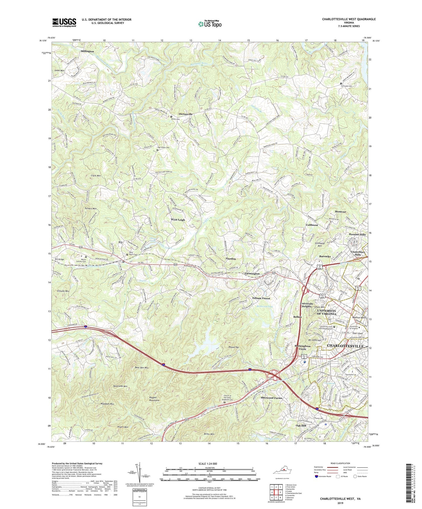
2022 topographic map quadrangle Charlottesville West in the state of Virginia. Scale: 1:24000. Based on the newly updated USGS 7.5' US Topo map series, this map is in the following counties: Albemarle, Charlottesville (city). The map contains contour data, water features, and other items you are used to seeing on USGS maps, but also has updated roads and other features. This is the next generation of topographic maps. Printed on high-quality waterproof paper with UV fade-resistant inks.
Quads adjacent to this one:
West: Crozet
Northwest: Browns Cove
North: Free Union
Northeast: Earlysville
East: Charlottesville East
Southeast: Simeon
South: Alberene
Southwest: Covesville
This map covers the same area as the classic USGS quad with code o38078a5.
Contains the following named places: Albemarle County, Albemarle High School, Albermarle County Farm, Alderman Memorial Library, Alderman Road Residence Area, Alumni Hall, Arbor Park, Artificial Turf Field, Azalea Park, Ballard Woods, Balz House, Barracks, Barracks Road Post Office, Barracks Road Shopping Center, Barracks Stud Riding Academy, Barrackside, Bayly Museum, Bear Den Mountain, BeauPre, Bellair, Bemiss House, Birdwood Clubhouse & Golf Course, Birdwood Dam, Birdwood Golf Course, Birdwood Lake, Birdwood Pavilion, Biscuit Run, Boxwood, Britts Mountain, Brooks Museum, Brown College at Monroe Hill, Buckingham Circle, Cabell Hall, Campbell Hall, Candlewyck, Canterbury Hills, Carr's Hill, Carr's Hill Field, Charlottesville Reservoir, Charlottesville-Albemarle Community Mental Health Hospital, Church of the Good Shepherd Cemetery, Clark Hall, Clark Mountain, Clearview Knolls, Clearview Meadows, Clover Dam, Clover Lake, Colthurst, Copeley Hill Residence Area, Corner Shops Shopping Center, Corruthers Hall, Country Green, Courtenay House, Culbreth and Helms Theatre, Darden Graduate Business School, Darden School Grounds, David A Harrison III Law Grounds, David C Wilson Neuro-Psychiatric Hospital, Decca, Dillard House, Dobie House, Dry Bridge, Dunglison House, Dunnington House, Eagle Hill, East Lawn, Echo Hill, Ednam, Ednam Forest, Ednam Village, Farmington, Farmington Country Club, Farmington Hunt Clubhouse, Faulkner Complex, Faulkner House, Fayerweather Hall, Fitzhugh House, Flordon, Foxfield, Frys Spring, Frys Spring Park, Galliston Hall, Garth House, Georgetown Green, Gilmer Hall, Glass Hat, Gooch Houses, Hardendale, Hereford Residential College, Hessian Hills, Hickory Hill, Huntington Village, Inglecress, Ingleside, Institute of Textile Technology, International Residential College, Ivy, Ivy Census Designated Place, Ivy Creek Cemetery, Ivy Farms, Ivy Oaks, Ivy Post Office, Ivy Ridge, Ivy Square Shopping Center, Jack Jouett District, Jack Jouett Middle School, Jackson - Via Elementary School, Jefferson Park, Jessups Dam, Jessups Lake, John Paul Jones Arena, Johnson Elementary School, Jordan Hall, Judge Advocate Generals School, Judge Advocate General's School, Jumping Branch, Kearny Mansion, Klockner Stadium, Kluge Children's Rehabilitation Center, Knollwood, Lady Astor Tennis Courts, Lambeth Field, Lambeth Field Residences Area, Langford, Lannigan Field, Leander J McCormick Observatory, Lewis Hill East, Lewis Hill West, Lewis Mountain, Liberty Hill, Lile House, Little Ivy Creek, Loch Leigh, Locust Hill, Logan Village, Lone Pine School, Madison Bowl, Madison Hall, Mary Greer Elementary School, Mary Munford House, Maupin House, McCormick Road Residence Area, McIntire Amphitheatre, McKim Hall, McLeod Hall, Meadowbrook Shopping Center, Memorial Gymnasium, Meriwether Hill, Meriwether Lewis Elementary School, Midway, Mill Ridge, Miller Center, Millington, Minor Hall, Monroe Hall, Montvue, Morey Creek, Mount Calvary Cemetery, Mount Jefferson, Nameless Field, National Radio Astronomy Observatory, Newcomb Hall, Newcomb Mountain, Nob Hill, Oak Hill, Oak Hill Mobile Home Park, Oak Union Cemetery, Oaken Croft Vineyard, Observatory Hill Dining Facility, Olivet Cemetery, Owensville, Parent Resource Center Piedmont Regional Education Program, Paul Goodloe McIntre Amphitheatre, Perry-Fishburne Tennis Courts, Piedmont Faculty Housing, Pryors Mountain, Queen Charlotte, Ragged Mountain - Number One Dam, Ragged Mountains, Reynard Woods, Rockfield School, Rocky Run, Roger Milliken Textile Library, Rotunda, Round Top, Rugby Road-University Corner Historic District, Saint Anne's - Belfield School, Saint Anne's - Belfield School Lower Campus, Saint Paul's Cemetery, Scott Stadium, Sheridan G Snyder Tennis Center, Sherwood Farms, Sherwood Manor, Sponsors Hall, Spring Creek, Spring Hill, Stadium Road Residence Area, Stillfield, Stillhouse Mountain, The Barracks, The Covenant School - Upper Campus, Thomas Edward Davenport Field, Thornton Hall, Turners Mountain, Tuttle House, University Gardens, University Hall, University Heights, University Montessori School, University of Virginia, University of Virginia Cemetery and Columbarium, University of Virginia Census Designated Place, University of Virginia HealthSouth Rehabilitation Hospital, University of Virginia Historic District, University of Virginia Kluge Children's Rehabilitation Center, Upper Ragged Mountain Dam Number One, Virginia L Murray Elementary School, Watson House, Waverly, Webb House, West Lawn, West Leigh, West Woods, Whipporwill Hollow, Whispering Pines, Wilson Hall, WINA-AM (Charlottesville), Wingate Farm, Woodson Mountain, Woodsons Store, WTJU-FM (Charlottesville), Wyngate, ZIP Codes: 22901, 22903, 22904