MyTopo
Earlysville Virginia US Topo Map
Couldn't load pickup availability
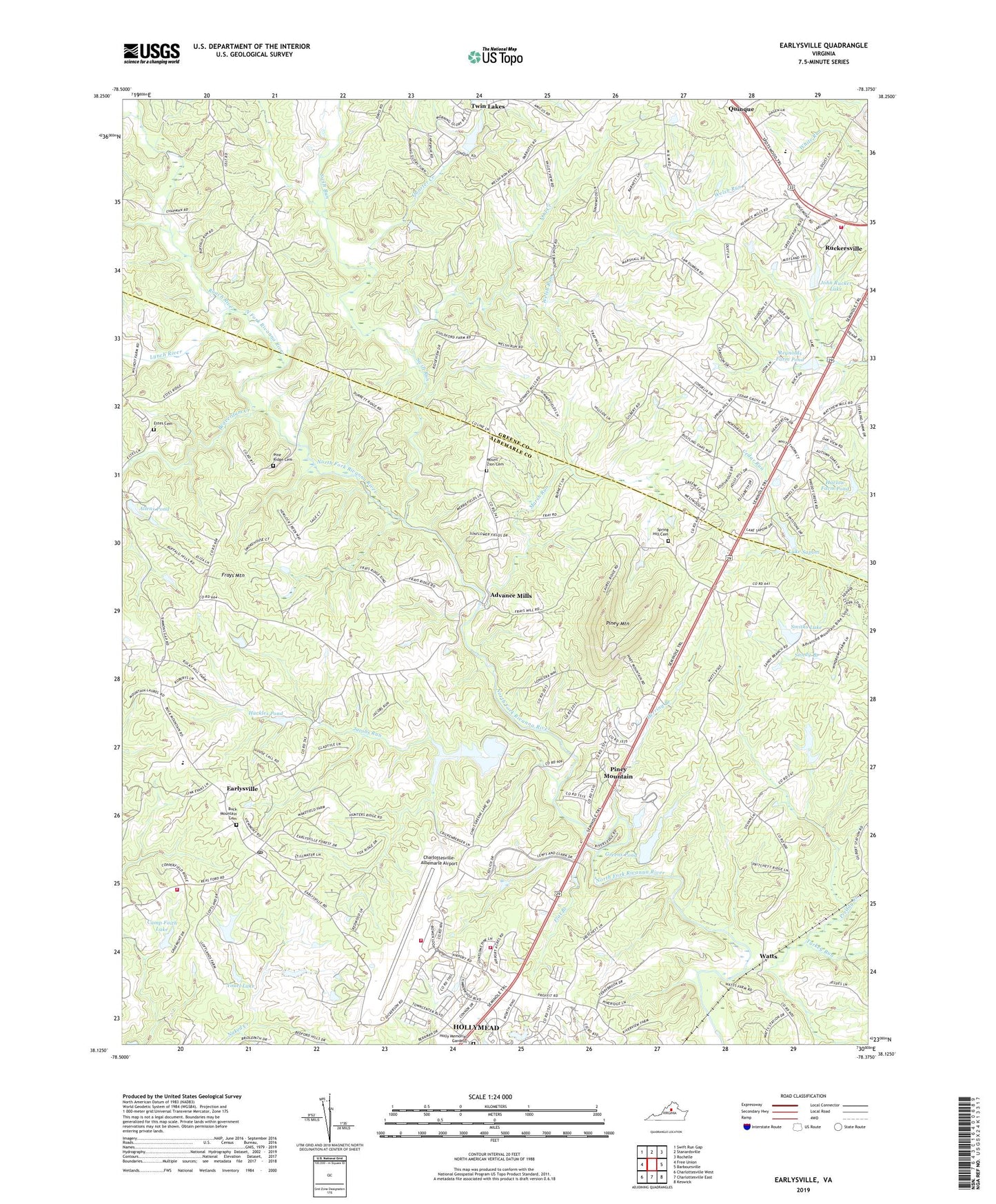
2022 topographic map quadrangle Earlysville in the state of Virginia. Scale: 1:24000. Based on the newly updated USGS 7.5' US Topo map series, this map is in the following counties: Albemarle, Greene. The map contains contour data, water features, and other items you are used to seeing on USGS maps, but also has updated roads and other features. This is the next generation of topographic maps. Printed on high-quality waterproof paper with UV fade-resistant inks.
Quads adjacent to this one:
West: Free Union
Northwest: Swift Run Gap
North: Stanardsville
Northeast: Rochelle
East: Barboursville
Southeast: Keswick
South: Charlottesville East
Southwest: Charlottesville West
This map covers the same area as the classic USGS quad with code o38078b4.
Contains the following named places: Advance Mills, Advance Mills School, Advance Mills Village, Airport Acres, Allens Dam, Allens Pond, Barnes, Beaverdam Creek, Bishops Dam, Bishops Lake, Borneo Post Office, Briarwood, Broadus Wood Elementary School, Buck Mountain Cemetery, Buck Mountain Church, Camelot, Camp Faith Lake, Camp Faith Lake Dam, Carpenter School, Cedar Grove Church, Cedar Hill Mobile Home Park, Celt, Celt Post Office, Celt School, Charlottesville - Albemarle Airport Fire Department, Charlottesville-Albemarle Airport, Chestnut Grove, Chestnut Grove Church, Chris Greene Lake, Chris Greene Lake Park, Cris Green Dam, Deer Run, Deerwood, Dunns Shop, Early Mill, Earlysville, Earlysville Census Designated Place, Earlysville Heights, Earlysville Post Office, Earlysville Volunteer Fire Company Station 4, Ehart, Estes Cemetery, Flat Branch, Frays Mountain, Frays Mountain Estates, Gilbert Heights, Greens Dam, Greens Pond, Harlow Farm Dam, Harlow Farm Pond, Herring Branch, Holly Memorial Gardens, Hollymead Census Designated Place, Hollymead Fire Rescue Station 12, Huckles Dam, Huckles Pond, Jacobs Run, Jefferson Village, John Rucker Lake, Lake Acres, Lake Saponi, Lake Saponi Dam, Laurel Hill Church, Lexington, Loftlands Dam, Loftlands Wood, Lower Lake Shenandoah, Lynch River, Maple Grove Church, Marsh Run, Midway, Midway District, Midway School, Mill Run, Mount Paran Church, Mount Zion Baptist Church, Mount Zion Cemetery, Mountain Chapel, Mountain Laurel, Mountain View School, North Fork Farms, North Pines, Northside Industrial Park, Northwoods Mobile Home Park, Norwood, Oaklawn, Oil Creek, Parker Branch, Pine Ridge Cemetery, Pine Ridge Church, Piney Mountain, Piney Mountain Census Designated Place, Preddy Creek, Quarter Creek, Reynolds Farm Dam, Reynolds Farm Pond, Reynolds Farm Route 29 Dam, Ridge School, Roach River, Ruckersville Census Designated Place, Ruckersville Elementary School, Ruckersville Volunteer Fire Company, Sandy Branch Resort Farm, Smiths Dam, Smiths Lake, Spring Hill Cemetery, Spring Hill Church, Springfield, Swift Run, Terrybrook, The Pines, Turkey Run, Twin Lakes, Twin Lakes Dam Number Two, Watts, Welsh Run, Wetsels, Wetsels Post Office, Youel Lake, ZIP Codes: 22936, 22968