MyTopo
Courtland Virginia US Topo Map
Couldn't load pickup availability
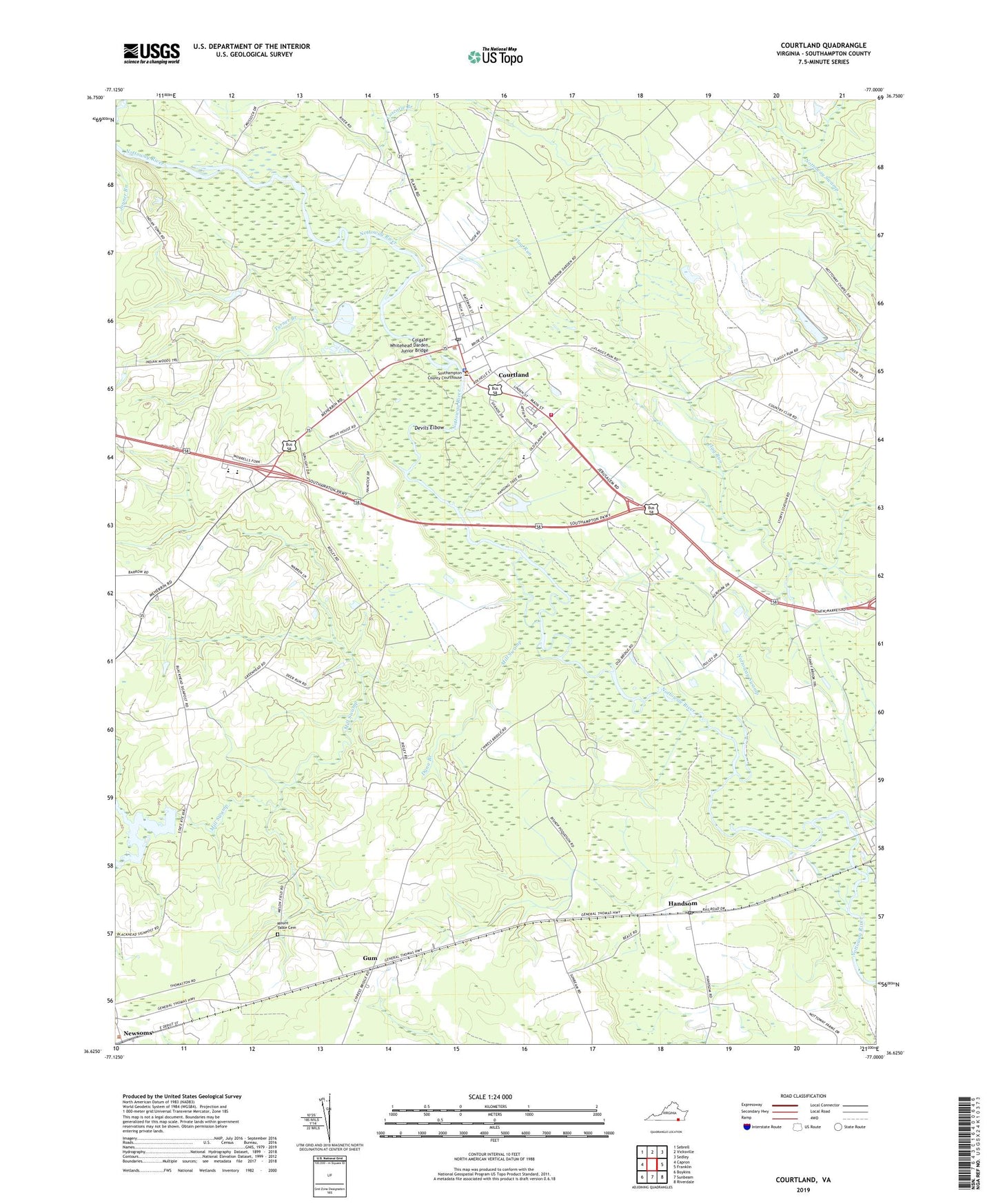
2022 topographic map quadrangle Courtland in the state of Virginia. Scale: 1:24000. Based on the newly updated USGS 7.5' US Topo map series, this map is in the following counties: Southampton. The map contains contour data, water features, and other items you are used to seeing on USGS maps, but also has updated roads and other features. This is the next generation of topographic maps. Printed on high-quality waterproof paper with UV fade-resistant inks.
Quads adjacent to this one:
West: Capron
Northwest: Sebrell
North: Vicksville
Northeast: Sedley
East: Franklin
Southeast: Riverdale
South: Sunbeam
Southwest: Boykins
This map covers the same area as the classic USGS quad with code o36077f1.
Contains the following named places: Assamoosick Swamp, Blackwater Regional Library Walter Cecil Rawls Library, Colgate Whitehead Darden Junior Bridge, Coscorie Branch, Courtland, Courtland Elementary School, Courtland Police Department, Courtland Post Office, Courtland Volunteer Fire Department, Courtland Volunteer Rescue Squad, Cypress Bridge, Darden Pond, Dardens Dam, Davis School, Delaware, Delaware Park, Devils Elbow, Dunn Branch, Ebenezer Church, Flag Run, Gum, Handsom, Handsom Post Office, Holderness Church, Jerusalem District, Lifestar Ambulance Service Courtland, Mill Swamp, Mount Tabor Baptist Church Cemetery, Newsoms District School, Newsoms Police Department, Nottoway Church, Nottoway Swamp, Riverview High School, Saint Pauls Church, Sandy Hill School, School Number 4, Southampton Academy, Southampton County, Southampton County Sheriff's Office, Southampton High School, Southampton Middle School, Southampton Technical Career Center, Story, Tavern School, Town of Courtland, Town of Newsoms, Turner Branch, Vicks Island, Whitehouse Swamp, Williams Chapel, WLQM-FM (Franklin), WWWP-FM (Franklin), Zion Hill Church, ZIP Code: 23837