MyTopo
Deep Creek Virginia US Topo Map
Couldn't load pickup availability
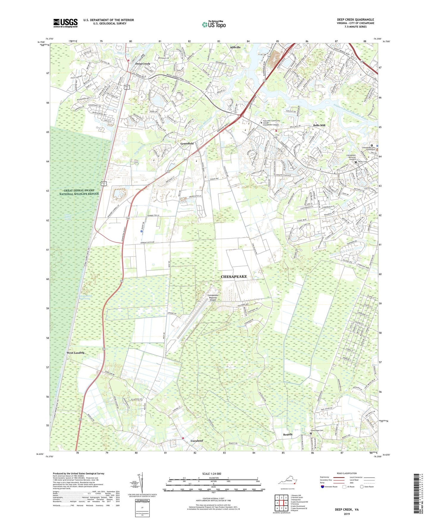
2022 topographic map quadrangle Deep Creek in the state of Virginia. Scale: 1:24000. Based on the newly updated USGS 7.5' US Topo map series, this map is in the following counties: Chesapeake (city). The map contains contour data, water features, and other items you are used to seeing on USGS maps, but also has updated roads and other features. This is the next generation of topographic maps. Printed on high-quality waterproof paper with UV fade-resistant inks.
Quads adjacent to this one:
West: Lake Drummond NW
Northwest: Bowers Hill
North: Norfolk South
Northeast: Kempsville
East: Fentress
Southeast: Moyock
South: Lake Drummond SE
Southwest: Lake Drummond
This map covers the same area as the classic USGS quad with code o36076f3.
Contains the following named places: Autumn Care of Great Bridge Nursing Home, Bells Mill, Benefit, Berea Cemetery, Bethel Temple, Bethlehem Church, Big Entry, Big Entry Ditch, Cahoon Airport, Cahoon Plantation Golf Course, Calvary Community Church of Chesapeake, Camp Civitan, Cedar Road Christian Academy, Cedar Road Church, Cedar Road Elementary School, Cedarwood Industrial Park, Chesapeake Alternative School, Chesapeake Center for Science and Technology, Chesapeake City Sheriff's Office, Chesapeake Correctional Center, Chesapeake Fire Department Station 13 Cornland, Chesapeake Fire Department Station 15, Chesapeake Fire Department Station 8 Deep Creek, Chesapeake First Church of the Nazarene, Chesapeake Golf Club, Chesapeake Juvenile Detention Services, Chesapeake Memorial Gardens, Chesapeake Police Department Training Academy, Chesapeake Regional Airport, City of Chesapeake, Cornland, Cornland School, Deep Creek, Deep Creek Central Elementary School, Deep Creek Intermediate School, Deep Creek Lock, Deep Creek Lock Park, Deep Creek School, Douglas Landing, Dove Acres, Faith Hope and Charity Number 2 Church, Formes Temple, Good Hope Cemetery, Good Hope Church, Grassfield, Grassfield Baptist Church, Grassfield Elementary School, Great Bridge Church of God, Great Bridge Presbyterian Church, Great Bridge Presbyterian Preschool, Great Bridge Primary School, Greater Bethel Church, Greater Southside Church, Green Sea, Herberts Corner, Herons Canal, Herring Ditch, Holy Temple Ministry, Hugo A Owens Middle School, Inland Colony, Las Gaviotas Shopping Center, Lees Chapel African Methodist Episcopal Church, Lindsey Canal, Millville, Mount Lebanon Baptist Church, Mount Lebanon Christian Academy, New Begining Worship Center, New Light Church, New Mill Creek, North Martha Washington Ditch, Oscar F Smith High School, Parkview, Paul Creek, Pines of Warrick, Refuge Mission Church, Rock Creek, Rosemary Ditch, Sampson Creek, Seabrooke Landing, Shipyard School, Sykes Creek, Tidewater Community College - Chesapeake Campus, Tidewater Juvenile Detention Home, Trinity Baptist Church, Waters Road Church, West Landing, West Road Church, WFOS-FM (Chesapeake), WHRO-FM (Chesapeake), Youngs Camp