MyTopo
Gate City Virginia US Topo Map
Couldn't load pickup availability
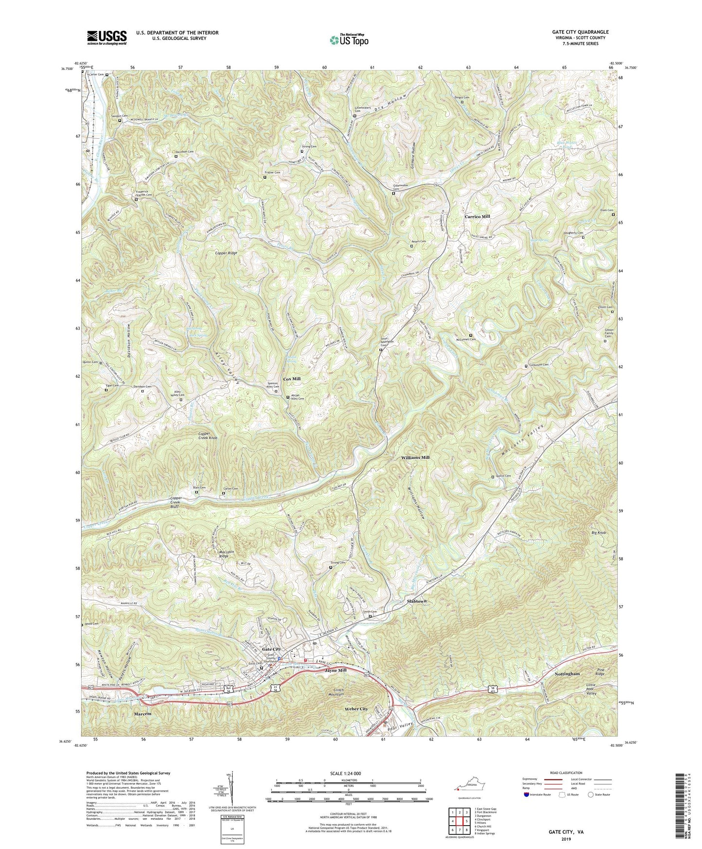
2019 topographic map quadrangle Gate City in the state of Virginia. Scale: 1:24000. Based on the newly updated USGS 7.5' US Topo map series, this map is in the following counties: Scott. The map contains contour data, water features, and other items you are used to seeing on USGS maps, but also has updated roads and other features. This is the next generation of topographic maps. Printed on high-quality waterproof paper with UV fade-resistant inks.
Quads adjacent to this one:
West: Clinchport
Northwest: East Stone Gap
North: Fort Blackmore
Northeast: Dungannon
East: Hiltons
Southeast: Indian Springs
South: Kingsport
Southwest: Church Hill
Contains the following named places: Abijah Alley Cemetery, Addington Store, Alley Valley, Alley Valley Cemetery, Antioch Church, Big Knob, Big Spring, Blair Cemetery, Blue Water Pond, Buck Spring, Burnt Cabin Branch, Carrico Mill, Carter Cemetery, Chapman Branch, Church of Christ, Copper Creek Bluff, Copper Creek Knobs, Cove Creek, Cox Mill, Culbutson Cemetery, Davidson Cemetery, Davidson Hollow, Dingus Cemetery, District 4, Dougherty Cemetery, Dry Hollow, Egan Cemetery, Elam Cemetery, Elliott Cemetery, Estill Cemetery, Farley Chapel, Flower Branch, Franklin Branch, Frazier Cemetery, Frederick Starnes Cemetery, Gate City, Gate City Baptist Church, Gate City High School, Gate City Middle School, Gate City Police Department, Gate City Post Office, Gate City Town Hall, Gate City United Methodist Church, Gate City Volunteer Fire Department, Gibson Family Cemetery, Gillenwater Branch, Gillenwater Cemetery, Gillenwaters Cemetery, Gilmore Hollow, Hale Spring, Irvington Church, Jayne Mill, Lark Creek, Little Moccasin Creek, Little Poor Valley, Lydia Church, Marcem, McConnell Cemetery, McConnell Church, McDowell Branch, Midway Church, Midway School, Mineral Hill Church, Moccasin Gap, Moccasin Siding, Moccasin Valley, Moore Memorial Church, Mount Pleasant Church, Mount View School, Newton Hollow, Nottingham, Obeys Creek, Obies Creek Mill, Peters Branch, Peters Cemetery, Peters Hollow, Pike, Pine Branch, Plank Camp Creek, Prospect School, Quillin Cemetery, Quillin Spring, R P Kane Athletic Field, Red Hill Branch, Red Hill Church, Red Hill School, Salling Cemetery, Sanders Cemetery, Scott County, Scott County Career and Technical Center, Scott County Courthouse, Scott County Jail, Scott County Library, Scott County Life Saving Crew, Scott County Sheriff's Office, Shoemaker Elementary School, Slabtown, Slant Church, Slant Post Office, Smith Cemetery, Solon Addington Cemetery, Spencer Alley Cemetery, Starnes Bluff Church, Strong Branch, Strong Cemetery, Strong School, Town of Gate City, Union Church, Valley Creek, Walnut Grove Church, Webber Church, Weber City Police Department, Weber City Post Office, Weber City Town Hall, WGAT-AM (Gate City), Widow Branch, Williams Hollow, Williams Mill, Wood Cemetery, ZIP Code: 24251