MyTopo
Martinsville East Virginia US Topo Map
Couldn't load pickup availability
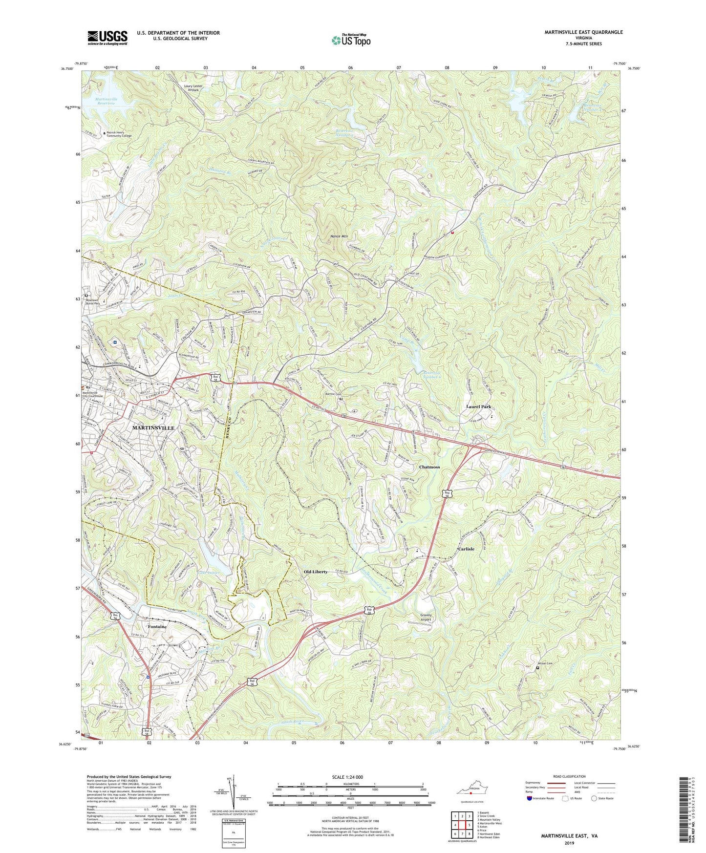
2022 topographic map quadrangle Martinsville East in the state of Virginia. Scale: 1:24000. Based on the newly updated USGS 7.5' US Topo map series, this map is in the following counties: Henry, Martinsville (city). The map contains contour data, water features, and other items you are used to seeing on USGS maps, but also has updated roads and other features. This is the next generation of topographic maps. Printed on high-quality waterproof paper with UV fade-resistant inks.
Quads adjacent to this one:
West: Martinsville West
Northwest: Bassett
North: Snow Creek
Northeast: Mountain Valley
East: Axton
Southeast: Northeast Eden
South: Northwest Eden
Southwest: Price
This map covers the same area as the classic USGS quad with code o36079f7.
Contains the following named places: Ballast Siding, Barrow Cemetery, Beaver Creek Dam, Beckham Church, Beckham School, Broad Street Christian Church, Calvary Christian Church, Camp Branch, Camp Branch School, Carlisle, Carlisle School, Cedar Chapel, Central Martinsville Post Office, Chatmoss, Chatmoss Census Designated Place, Chatmoss Country Club, Christ Episcopal Church, Church of Christ, City of Martinsville, Clearview Early Childhood Center, Cobbs Creek, Crossroads School, Druid Hills Elementary School, Dyers Store, Dyers Store Volunteer Fire Department, East Martinsville School, Ellsworth Street Baptist Church, English Field, Fall Creek Church, Fall Creek School, First Baptist Church, First United Methodist Church, Fontaine, Fontaine Church, Fontaine School, Forest Hills Presbyterian Church, Forest Park Country Club, Galilee Church, Gravely Airport, Hairston Branch, Henry County Courthouse, Henry County Jail, Hilltop, Holy Trinity Lutheran Church, Jerusalem Church, Kate Anderson Presbyterian Church, Kate Anderson School, Kingdom Hall of Jehovahs Witnesses, Lake Lanier, Lake Lanier Dam, Lanier Farm School, Laurel Park, Laurel Park Census Designated Place, Laurel Park Middle School, Laurel Park Plaza Shopping Center, Leatherwood Church, Leatherwood Creek Number 2a Dam, Leatherwood Creek Number Four Dam, Leatherwood Creek Number Six Dam, Leatherwood Creek Number Three Dam, Leatherwood School, Loury Lester Airpark, Machine Branch, Martinsville, Martinsville - Henry County Rescue Squad, Martinsville City Jail, Martinsville Fire and Emergency Medical Services Station 2, Martinsville General Hospital, Martinsville High School, Martinsville Middle School, Martinsville Police Department, Martinsville Post Office, Martinsville Public Library, Martinsville Pumping Station, Martinsville Reservoir, Martinsville Speedway, Martinsville-Henry County Memorial Hospital Heliport, Memorial Hospital of Martinsville, Mill Creek, Minter School, Morningside Church, Mount Olivet Church, Mount Olivet Elementary School, Mulberry Creek, Nance Mountain, North Fork Jones Creek, North Martinsville School, Old Liberty, Patrick Henry Community College, Patrick Henry Elementary School, Patrick Henry Mall Shopping Center, Patrick Henry Monument, Patterson Branch, Pentecostal Holiness Church, Peters Branch, Pilgrims Gospel Tabernacle, Reservoir Number 2, Reservoir Number 3, Reservoir Number 4, Reservoir Number 6, Rich Acres Elementary School, Rock Hill Church, Roselawn Burial Park, Starling Avenue Baptist Church, Stone Ambulance Service, Stony Mountain Church, Tanyard Branch, University of Virginia, Virginia State Police Division 6 Area 42 Office, Wesley Memorial United Methodist Church, West Fork Leatherwood Creek, Wet Branch, Wilson Cemetery, WMVA-AM (Martinsville), Woodland Heights Church, ZIP Code: 24112