MyTopo
Stanardsville Virginia US Topo Map
Couldn't load pickup availability
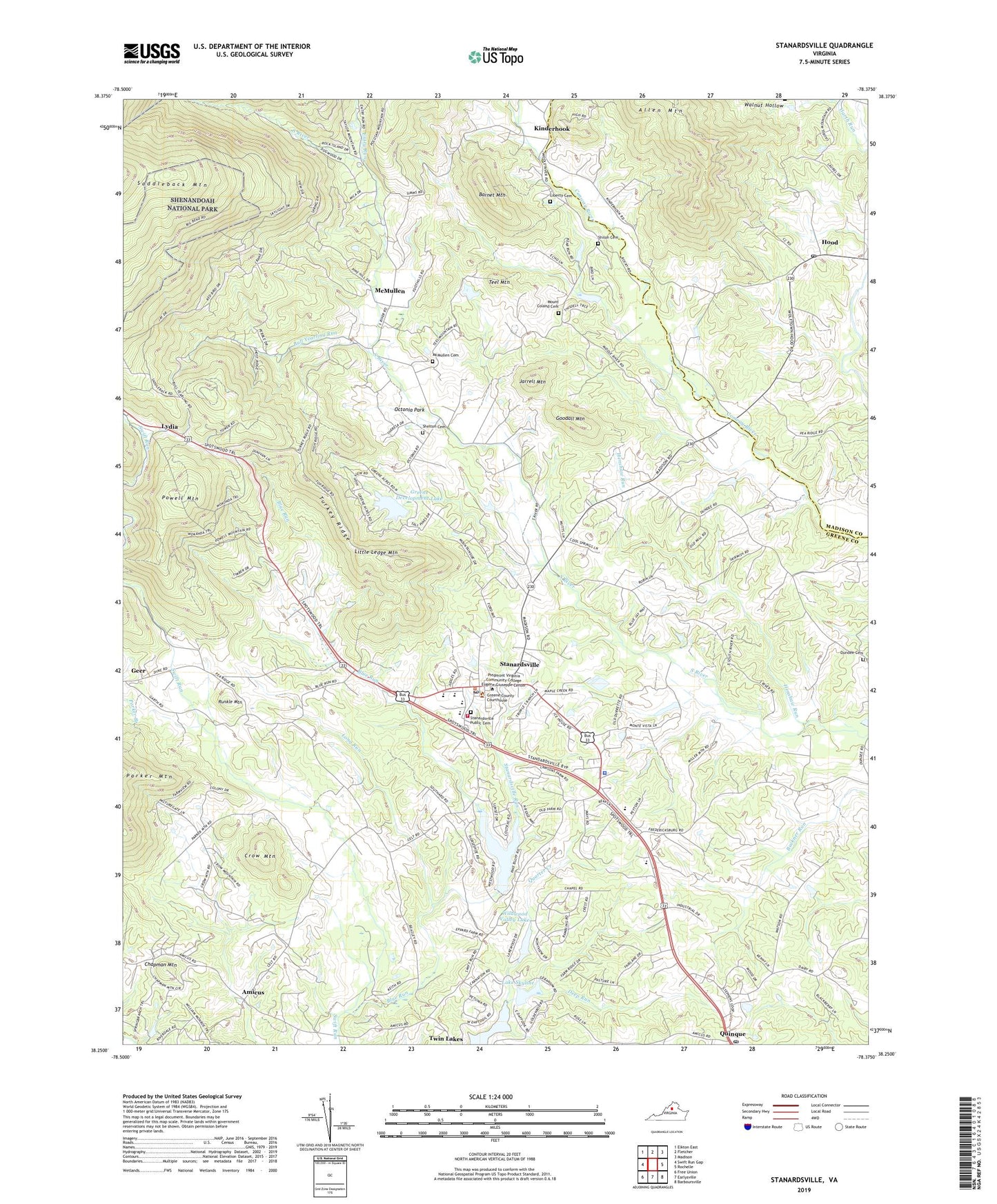
2019 topographic map quadrangle Stanardsville in the state of Virginia. Scale: 1:24000. Based on the newly updated USGS 7.5' US Topo map series, this map is in the following counties: Greene, Madison. The map contains contour data, water features, and other items you are used to seeing on USGS maps, but also has updated roads and other features. This is the next generation of topographic maps. Printed on high-quality waterproof paper with UV fade-resistant inks.
Quads adjacent to this one:
West: Swift Run Gap
Northwest: Elkton East
North: Fletcher
Northeast: Madison
East: Rochelle
Southeast: Barboursville
South: Earlysville
Southwest: Free Union
Contains the following named places: Allen Mountain, Amicus, Barnet Mountain, Blue Run, Bootons Mill, Brayton Post Office, Brills Shop, Bull Yearling Run, Cecil Mission, Chapman Mountain, Crow Mountain, Dawsons Shop, Deep Run, Dundee Baptist Church, Dundee Cemetery, Entry Run, Eppards Mill, First Bible Church, Geer, Geer Post Office, Goodall Mountain, Green Mountain Lake, Green Mountain Lake Dam, Greene Acres Dam, Greene County, Greene County Courthouse, Greene County Rescue Squad, Greene County Sheriff's Office, Greene County Technical Education Center, Greene Development Lake, Greene Hills Dam, Greene Hills Lake, Greene Valley Section Seven Dam, Haney, Haney Post Office, Harlows Corner, Henshaw Run, Hood, Hood Post Office, Jarrell Mountain, Kinderhook, Kinderhook Post Office, Lake Shenandoah, Lake Skyline, Liberty Cemetery, Liberty Church, Little Ledge Mountain, Long Run, Lydia, Lydia Church, Lydia Post Office, Lydia School, McMullen, McMullen Cemetery, McMullen Post Office, Middle River Church, Mount Coland Cemetery, Mount Coland Church, Mount Hermon Church of the Brethren, Mount Vernon Church, Mountain View Church, Mountain View Greenhouse, Nathanael Greene Elementary School, Nathanael Greene Primary School, Octonia Park, Octonia Rockshelter, Pages Mill, Powell Mountain, Pruess Farm Dam, Pruess Farm Pond, Quinque, Quinque Post Office, Quinquie Post Office, Roudabush, Roudabush Post Office, Runkle Mountain, Shelton Cemetery, Shiloh Baptist Church, Shiloh Cemetery, South River Church, South River School, Stanardsville, Stanardsville Baptist Church, Stanardsville District, Stanardsville Post Office, Stanardsville Public Cemetery, Stanardsville Run, Stanardsville School, Stanardsville Volunteer Fire Department Station 1, Swift Run Church, Swift Run School, Teel Mountain, The Brush, Town of Stanardsville, Turkey Ridge, Twin Lakes Census Designated Place, Twin Lakes Dam Number One, Twin Lakes Dam Number Three, Wildwood Valley Lake, Wildwood Valley Lake Dam, William Monroe High School, William Monroe Middle School, WKTR-AM (Earlysville), ZIP Codes: 22723, 22973