MyTopo
Thoroughfare Gap Virginia US Topo Map
Couldn't load pickup availability
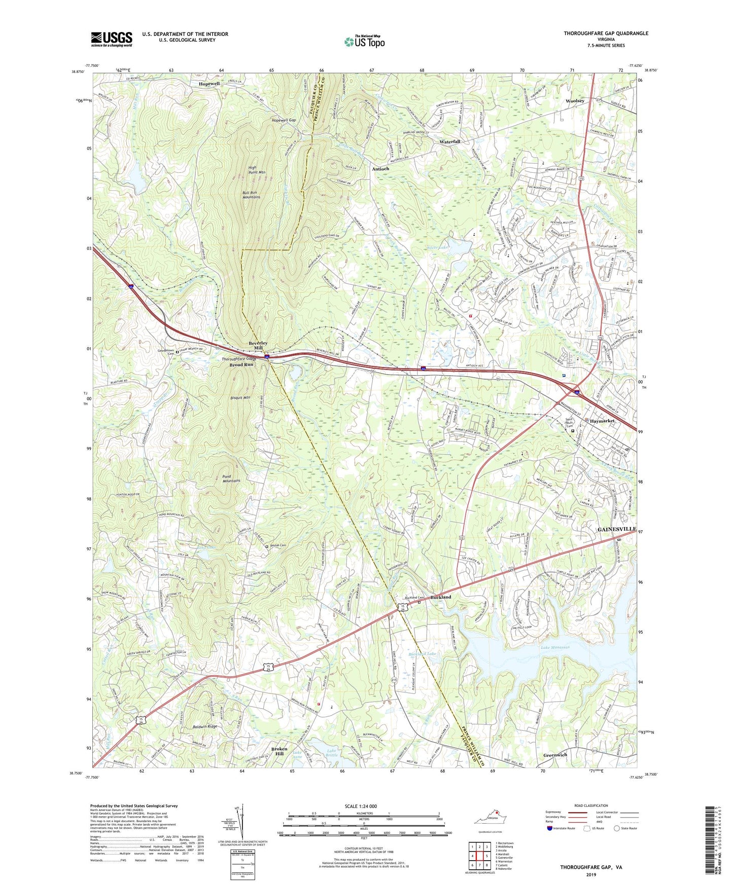
2022 topographic map quadrangle Thoroughfare Gap in the state of Virginia. Scale: 1:24000. Based on the newly updated USGS 7.5' US Topo map series, this map is in the following counties: Prince William, Fauquier. The map contains contour data, water features, and other items you are used to seeing on USGS maps, but also has updated roads and other features. This is the next generation of topographic maps. Printed on high-quality waterproof paper with UV fade-resistant inks.
Quads adjacent to this one:
West: Marshall
Northwest: Rectortown
North: Middleburg
Northeast: Arcola
East: Gainesville
Southeast: Nokesville
South: Catlett
Southwest: Warrenton
This map covers the same area as the classic USGS quad with code o38077g6.
Contains the following named places: Antioch, Antioch Elementary School, Antioch-McCrae School, Avenel, Baldwin Ridge, Battlefield High School, Beulah Cemetery, Beulah Church, Beverley Mill, Bisquit Mountain, Broad Run, Broad Run Church, Broad Run Post Office, Broken Hill, Buckland, Buckland Cemetery, Buckland Dam, Buckland Historic District, Buckland Lake, Buckland Mills Elementary School, Buckland Pentecostal Church, Burke Meadows, C Hunter Ritchie Elementary School, Camp William B. Snyder, Catletts Branch, Cattail Run, Church of Our Savoir, Crescent, Eastview, Echo Lake, Echo Lake Dam, Evergreen, Foley Plantation, Gainesville Census Designated Place, Gainesville Elementary School, Gainesville Mini Library, Gainesville Neighborhood Library, Gainesville Post Office, Gainesville School, Georgetown Cemetery, Grace Chapel, Haymarket, Haymarket Baptist Church, Haymarket Medical Center, Haymarket Police Department, Haymarket Post Office, Haymarket Town Hall, High Point Mountain, Hopewell, Hopewell Gap, Hygeia Academy, J W Alvey Elementary School, Jackson Hollow, James S Long Park, Kennard Ridge, Kinloch Farm Dam, Kinloch Farm Pond, Knollwood Estates, Lake Anne Dam, Lake Brittle, Lake Manassas, Little Georgetown, Mill Run, Mount Pleasant Church, Mountain View Elementary School, Mountain View Estates, New Baltimore, New Baltimore Business Park, New Baltimore Industrial Park, New Baltimore Volunteer Fire and Rescue Company 10, North Fork Broad Run, Oakrum Church, Olive Branch Church, Partridge School, Paynes Quarry, Pilgrim Rest School, Pilgrims Rest, Pond Mountains, Prince William County Department of Fire and Rescue Station 24, Saint Paul's Cemetery, Saint Pauls Church, Silver Lake, Silver Lake Dam, Sisslers Quarry, South Run, Thoroughfare, Thoroughfare Gap, Town of Haymarket, Trapp Branch, Vint Hill Park, Vint Hills Farm Station Heliport, Waterfall, Waterfall Park, Waterfall Village, WDAW-AM (Haymarket), WKCW-AM (Warrenton), Woolsey, ZIP Code: 20137