MyTopo
Marshall Virginia US Topo Map
Couldn't load pickup availability
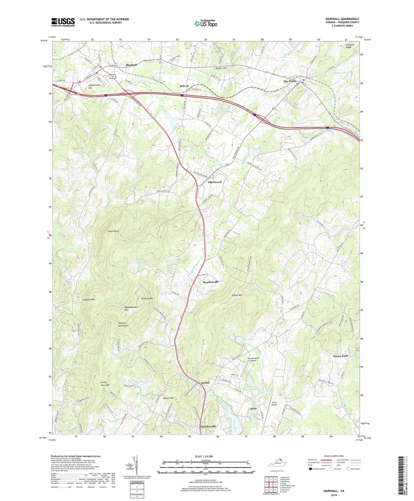
2022 topographic map quadrangle Marshall in the state of Virginia. Scale: 1:24000. Based on the newly updated USGS 7.5' US Topo map series, this map is in the following counties: Fauquier. The map contains contour data, water features, and other items you are used to seeing on USGS maps, but also has updated roads and other features. This is the next generation of topographic maps. Printed on high-quality waterproof paper with UV fade-resistant inks.
Quads adjacent to this one:
West: Orlean
Northwest: Upperville
North: Rectortown
Northeast: Middleburg
East: Thoroughfare Gap
Southeast: Catlett
South: Warrenton
Southwest: Jeffersonton
This map covers the same area as the classic USGS quad with code o38077g7.
Contains the following named places: Airlie, Airlie Airport, Airlie Dam, Airlie Lake, Bellevue Farms Dam Number Three, Belvoir, Belvoir Assembly of God Church, Belvoir Farm Dam, Belvoir Farm Lake, Bethel, Bethel Church, Bethel School, Bethel United Methodist Church, Bowmans Dam, Bowmans Pond, Brookes Corner, Bunker Hill, Edwardsville, England Mountain, Enon Church, First Baptist Church, Fletcherville, Foster Fork, Foster Hill School, Fox Dam, Fox Pond, Frye House, Grace Episcopal Church, Great Meadow Park, Groomes Crossroads, Halls Point, Horner Run, Johnsons Dam, Johnsons Pond, Little Zion Church, Littte Graces Preschool, Marshall, Marshall Census Designated Place, Marshall Methodist Episcopal Church, Marshall Middle School, Marshall Post Office, Marshall Vocational School, Marshall Volunteer Fire Department Company 3, Marshall Volunteer Rescue Squad, Marshall Volunteer Rescue Squad Company 9, Meadowville, Merry Oak Dam, Merry Oak Lake, Old Tavern, Piedmont Heights, Pignut Mountain, Piney Branch, Prickly Pear Mountain, Public School Number 18, Rappahannock Mountain, Road Island, Rosstown, Saint Marks United Methodist Church, Salem Baptist Church, Salem Station, Scott District, Second Mount Morris Church, Stephensons Hill, Taylors Church, The John Marshall Library, The Meadows Airport, The Plains, The Plains Baptist Church, The Plains Post Office, The Plains Volunteer Fire and Rescue Company 4, Town of The Plains, W G Coleman Elementary School, Wakefield School, Walkers Corner, Waters Mountain, Watery Mountains, Waveland, Wheatland, Wildcat Mountain, Willow Dam, Willow Lake, WMJR-FM (Warrenton)