MyTopo
Shelton Washington US Topo Map
Couldn't load pickup availability
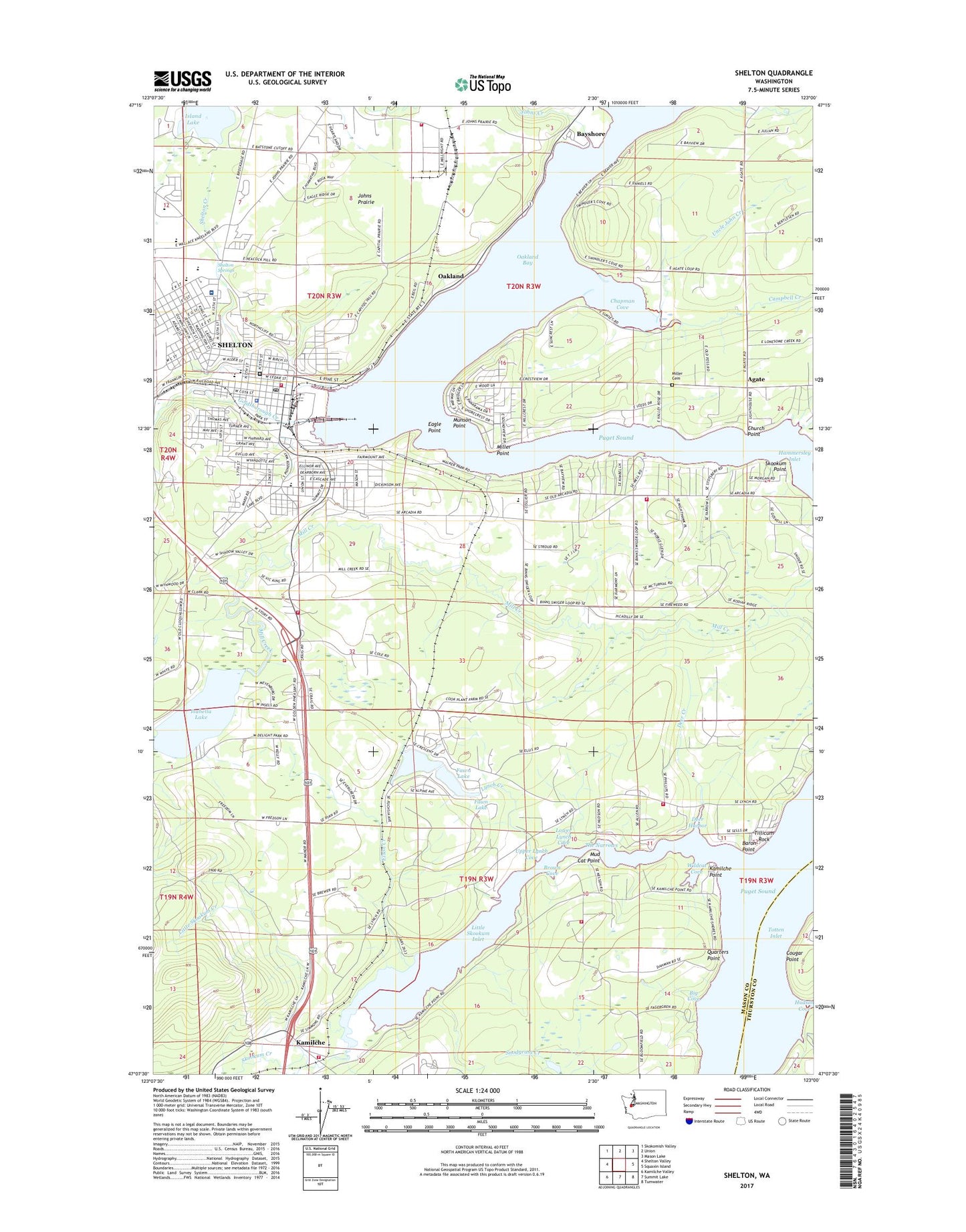
2023 topographic map quadrangle Shelton in the state of Washington. Scale: 1:24000. Based on the newly updated USGS 7.5' US Topo map series, this map is in the following counties: Mason, Thurston. The map contains contour data, water features, and other items you are used to seeing on USGS maps, but also has updated roads and other features. This is the next generation of topographic maps. Printed on high-quality waterproof paper with UV fade-resistant inks.
Quads adjacent to this one:
West: Shelton Valley
Northwest: Skokomish Valley
North: Union
Northeast: Mason Lake
East: Squaxin Island
Southeast: Tumwater
South: Summit Lake
Southwest: Kamilche Valley
This map covers the same area as the classic USGS quad with code o47123b1.
Contains the following named places: Agate, Alternative Continuation School, Baron Point, Bay Shore, Bayshore, Bethel Assembly of God Church, Big Cove, Bordeaux Elementary School, Brown Cove, Campbell Creek, Carmill Station, Chapman Cove, Church Point, City of Shelton, Coffee Creek, Cougar Point, Deer Creek, Deer Harbor, Eagle Point, Elizan Beach, Elson Creek, Evergreen Elementary School, Evergreen Shelton Health and Rehabilitation Center, Evergreen Square, Faith Lutheran Church, Fawn Lake, Fawn Lake Dam, Fir Lane Health and Rehabilitation Center, First Baptist Church, Gateway Christian Fellowship Church, Goldsborough Creek, Gospel Lighthouse Church, Grant C Angle School, Hammersley Inlet, Hoballa, Hudson Cove, Isabella Lake, Island Lake, Jacobys Shorecrest County Park, Johns Creek, Johns Prairie, Kamilche, Kamilche Point, KMAS-AM (Shelton), Little Skookum Creek, Little Skookum Inlet, Lower Lynch Cove, Lynch Creek, Mable Taylor Creek, Madrona Mobile Home Park, Mason County Building 1, Mason County Building 2, Mason County Building 3, Mason County Building 4, Mason County Building 5, Mason County Building 6, Mason County Building 7, Mason County Building 8, Mason County Building 9, Mason County Courthouse, Mason County Fire District 4 Station 41 Headquarters, Mason County Fire District 4 Station 42, Mason County Fire District 4 Station 44, Mason County Fire District 4 Station 45, Mason County Fire District 4 Station 46, Mason County Fire District 4 Station 47, Mason County Fire District 5 Shelton Fire Department Station 8, Mason County Fire District 5 Station 10 John Prairie, Mason County Jail, Mason County Juvenile Detention Center, Mason County Medic One, Mason County Sheriff's Office, Mason General Hospital, Mason General Hospital Heliport, Miller Cemetery, Miller Point, Mount Olive Lutheran Church, Mount View Alliance Church, Mountain View Elementary School, Mud Cat Point, Munson Point, New Horizons Church of God, Oakland, Oakland Bay, Oakland Bay Junior High School, Pines Mobile Home Park, Quarters Point, Reed High School, Riverside Mobile Home Park, Saint Edward's Catholic Church, Shelton, Shelton Bayshore Golf Club, Shelton Christian Church, Shelton City Police Department, Shelton Creek, Shelton Division, Shelton High School, Shelton Memorial Park, Shelton Post Office, Shelton Springs, Shelton United Methodist Church, Shelton Wastewater Treatment Plant, Skookum Creek, Skookum Point, Smith Island, Southside School, Taylor Towne Manor Mobile Home Park, The Church of Jesus Christ of Latter Day Saints, The Narrows, Tillicum Rock, Uncle John Creek, Upper Lynch Cove, We and You Mobile Home Park, We and You Recreational Vehicle Park, Wildcat Cove