MyTopo
Belle West Virginia US Topo Map
Couldn't load pickup availability
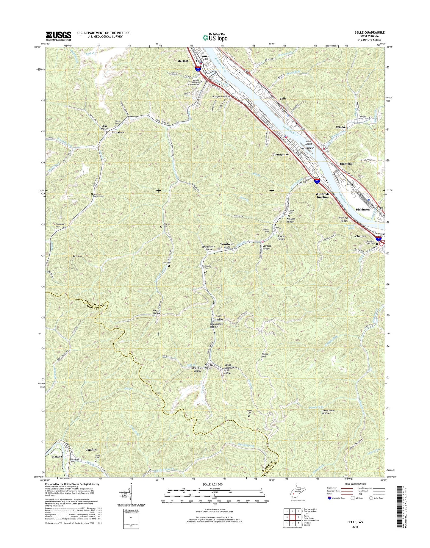
2019 topographic map quadrangle Belle in the state of West Virginia. Scale: 1:24000. Based on the newly updated USGS 7.5' US Topo map series, this map is in the following counties: Kanawha, Boone. The map contains contour data, water features, and other items you are used to seeing on USGS maps, but also has updated roads and other features. This is the next generation of topographic maps. Printed on high-quality waterproof paper with UV fade-resistant inks.
Quads adjacent to this one:
West: Racine
Northwest: Charleston West
North: Charleston East
Northeast: Quick
East: Cedar Grove
Southeast: Eskdale
South: Sylvester
Southwest: Williams Mountain
Contains the following named places: Bee Mountain, Bee Mountain Lookout Tower, Belle, Belle Church of the Nazarene, Belle Elementary School, Belle Police Department, Belle Post Office, Belle Presbyterian Church, Belle Volunteer Fire Department Main Station, Belle Volunteer Fire Department Witcher Station, Bradford Hollow, Bradley Fork, Brawleys Hollow, Carroll Branch, Carrow Fork, Chesapeake, Chesapeake City Hall, Chesapeake Elementary School, Chesapeake Police Department, Chesapeake Post Office, Chesapeake Volunteer Fire Department, Chesapeake Volunteer Fire Department Substation, Church of Christ, Church of the Nazarene, City of Marmet, Comfort, Comfort Census Designated Place, Comfort Elementary School, Comfort Post Office, Cooper Cemetery, Coopers Hollow, Diamond, Dickinson, Dotson Fork, Drummond Post Office, Dry Branch, Esta Church, Ferrell Cemetery, Fields Creek, Fourmile Fork, Frey Hollow, Frye Cemetery, Green Cemetery, Hawks Cemetery, Hernshaw, Hernshaw Post Office, Hoffman Cemeteries, Island Airport, James Kay Spring, Joes Branch, Joes Creek, Judson Baptist Church, Kanawha County Emergency Ambulance Authority Station 158, Kanawha County Emergency Ambulance Authority Station 59, Kanawha County Sheriff's Office - Quincy Detachment, Left Fork Lens Creek, Lens Creek, Lens Creek Church, Little Creek, Little Creek Church, Living Faith Christian Academy, Loudon District Junior High School, Maple Fork, Marmet, Marmet Baptist Church, Marmet City Hall, Marmet Elementary School, Marmet Fire Department, Marmet Hospital, Marmet Memorial Gardens Cemetery, Marmet Police Department, Marmet Post Office, Marmet Public Library, Massey Cemetery, Maxine, Meadows Cemetery, Midland Trail Elementary School, Mill Branch, Mitchell Cemetery, Naomi Church, New West Hollow, North Hollow, Old West Hollow, Opera House Hollow, Quincy Post Office, Reynolds Branch, Reynolds Memorial United Methodist Church, Ring Hollow, Riverside High School, Riverside Library, Sawmill Cemetery, Sawmill Hollow, Schoolhouse Hollow, Scott Branch, Scotts Island, Sherman Elementary School, Simmons Creek, Simmons Creek Church, Sixmile Branch, Slaughter Creek Cemetery, Snodgrass Cemetery, South Hollow, Spicelick Fork, Spruce Fork, Sweethome Hollow, Town Hollow, Town of Belle, Town of Chesapeake, Trace Fork, Upper Kanawha Valley Christian School, Walker I Heliport, West Virginia State Police Troop 4 - Quincy Detachment, Winifrede, Winifrede Junction, Winifrede Post Office, Witcher, Witcher Baptist Church, Witcher Cemetery, Witcher Creek, Wolfpen Hollow, Wrightsville Cemetery, ZIP Codes: 25024, 25035, 25107, 25214, 25315