MyTopo
Blacksville West Virginia US Topo Map
Couldn't load pickup availability
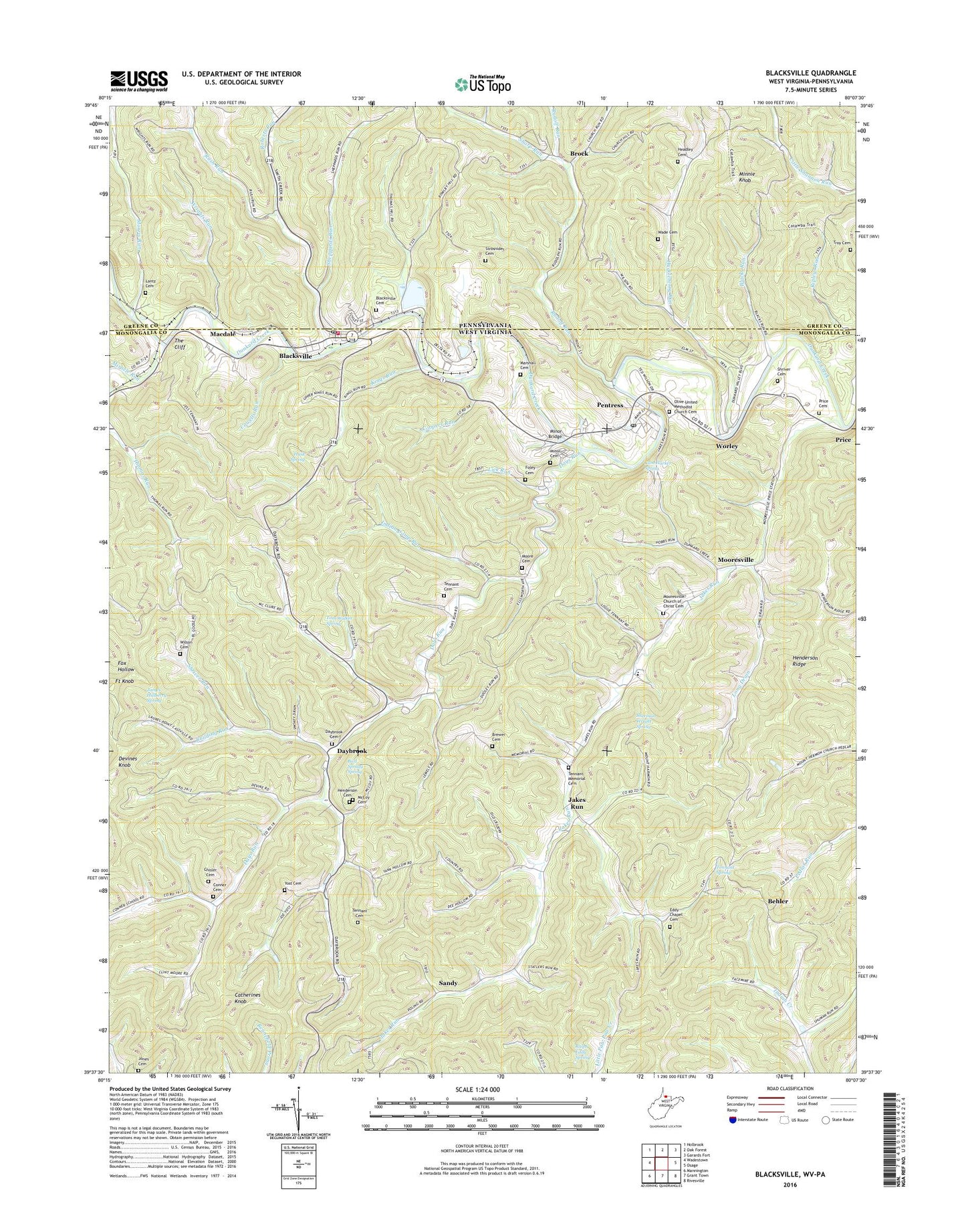
2023 topographic map quadrangle Blacksville in the states of West Virginia, Pennsylvania. Scale: 1:24000. Based on the newly updated USGS 7.5' US Topo map series, this map is in the following counties: Monongalia, Greene. The map contains contour data, water features, and other items you are used to seeing on USGS maps, but also has updated roads and other features. This is the next generation of topographic maps. Printed on high-quality waterproof paper with UV fade-resistant inks.
Quads adjacent to this one:
West: Wadestown
Northwest: Holbrook
North: Oak Forest
Northeast: Garards Fort
East: Osage
Southeast: Rivesville
South: Grant Town
Southwest: Mannington
This map covers the same area as the classic USGS quad with code o39080f2.
Contains the following named places: Behler, Bethel Wesleyan Methodist Church, Blacks Run, Blacks School, Blacksville, Blacksville Baptist Church, Blacksville Cemetery, Blacksville Elementary School, Blacksville Post Office, Blacksville United Methodist Church, Blacksville Volunteer Fire Department, Brewer Cemetery, Brock, Building Run, Burl Spragg Spring, Cam Harker Spring, Catherines Knob, Chisler Cemetery, Clay Batelle Public Library, Clay Battelle High School, Conner Cemetery, Coopers Run, Cowells Run, Daybrook, Daybrook Cemetery, Daybrook Church of Christ, Daybrook Elementary School, Daybrook High School, Days Run, Devines Knob, Dunkard Valley Golf Course, Eddy Chapel Cemetery, Foley Cemetery, Fort Knob, Hackelbender Run, Headley Cemetery, Henderson Cemetery, Henderson Ridge, Huckleberry Run, Husk Spring, Indian Camp Run, Jakes Run, Jakes Run Assembly of God, Jakes Run Early Childhood Center, Jakes Run Methodist Church, James Hillberry Spring, John, Jones Cemetery, Kings Run, Lantz Cemetery, Lick Run, Long Drain, Macdale, MacDale Church of Christ, Marshall Cemetery, McCoy Cemetery, Minnie Knob, Minor Bridge, Minor Cemetery, Miracle Run, Moore Cemetery, Mooresville, Mooresville Church of Christ, Mooresville Church of Christ Cemetery, Morris Run, Mount Harmon Dam, New Life Harvest Center, Olive United Methodist Church, Olive United Methodist Church Cemetery, Pentress, Pentress Census Designated Place, Pentress Post Office, Pentress Primary School, Price, Price Cemetery, Ralph Eddy Spring, Ripleys Run, Roberts Run, Rudolf Run, Rudolph Run, Rush Run, Sandy, Sharp Run, Sheppards Run, Sherman Wright Spring, Shriver Cemetery, Shriver Run, Strosnider Cemetery, Tennant Cemetery, Tennant Memorial Cemetery, Tennant Memorial Chapel Methodist Church, Tennant Spring, The Cliff, Tom Walker Spring, Town of Blacksville, Trinity Baptist Church, Troy Cemetery, Valley Chapel, Valley Chapel Cemetery, Wade Cemetery, Wilson Cemetery, Worley, Worley Cemetery, Wrights Run, Yost Cemetery, ZIP Codes: 26521, 26541, 26570