MyTopo
Elizabeth West Virginia US Topo Map
Couldn't load pickup availability
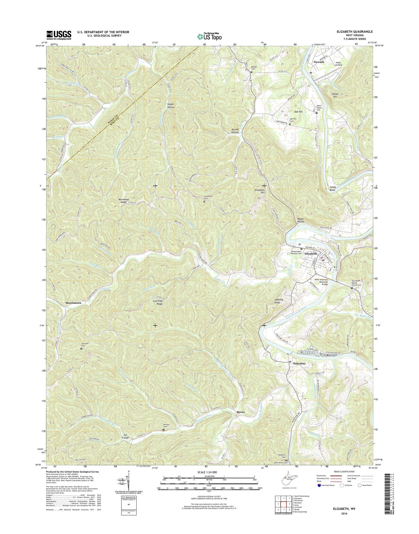
2023 topographic map quadrangle Elizabeth in the state of West Virginia. Scale: 1:24000. Based on the newly updated USGS 7.5' US Topo map series, this map is in the following counties: Wirt, Wood. The map contains contour data, water features, and other items you are used to seeing on USGS maps, but also has updated roads and other features. This is the next generation of topographic maps. Printed on high-quality waterproof paper with UV fade-resistant inks.
Quads adjacent to this one:
West: Rockport
Northwest: South Parkersburg
North: Kanawha
Northeast: Petroleum
East: Girta
Southeast: Burning Springs
South: Reedy
Southwest: Liverpool
This map covers the same area as the classic USGS quad with code o39081a4.
Contains the following named places: Antioch Baptist Church, Antioch Cemetery, Ballard Run, Beauchamp Cemetery, Bennett Run, Bethel United Methodist Church, Bethesda Baptist Church, Beulah Cemetery, Beulah Hill, Beulah Hill Community Building, Beulah-Humble Memorial Presbyterian Church, Black Hill School, Bloody Hollow, Brush Run, Buell Fork, Camp Barbe, Camp Sandy Bend, Center Hill School, Center Valley School, Central District, Central Hill Church, Courtney Ridge, Drift Run, Elizabeth, Elizabeth Baptist Church, Elizabeth Church of Christ, Elizabeth Church of the Nazarene, Elizabeth Grade School, Elizabeth Hill, Elizabeth Post Office, Elizabeth Volunteer Fire Department, Fairview Cemetery, Fairview Church, Grandview Cemetery, Grandview Church, Grieves Run, Grieves Run School, Gum Run, Hales Landing, Happy Hollow, Hickory Grove School, Horse Run, Indian Hill, Jephany Knob, Kingbury, Lee Creek, Lee Run, Little Horse Run, Little Road Run, Lock and Dam Number 4, Lynncamp Run, Mason Run, McKinley School, Mingo Bottom Golf Course, Morehead Ridge, Morristown, Mud Hill School, Mudlick Run, New Home Cemetery, New Home Methodist Church Cemetery, New Home United Methodist Church, Newark, Newark Census Designated Place, Newark Post Office, Newark School, Newark Station, Oak Hill, Oak Hill Cemetery, Oak Hill School, Palestine, Palestine Post Office, Palestine School, Palestine State Fish Hatchery, Pleasant Valley School, Red Hill School, Reedy Creek, Right Fork Lynncamp Run, Right Reedy Creek, River Valley Academy, Road Run, Rose Hill United Methodist Church, Rover, Rush Run, Rush Run School, Saint Elizabeth Catholic Church, Sand Hill Church, Sandy Bend, Sergeant Run, Shelving Rock Run, Shelving Rock School, Slate Church, Slatecamp Run, Snyder Hollow, Standingstone, Stark Run, Sugar Grove School, Tan Trough, Town of Elizabeth, Tucker Creek, Two Ripple Baptist Church Cemetery, Two Ripple Run, Two Ripple Run Church, Two Ripple Run School, Wells - Seaton Cemetery, West Point School, West Virginia State Police Troop 4 - Elizabeth Detachment, Wirt County, Wirt County Courthouse, Wirt County Emergency Squad, Wirt County High School, Wirt County Middle School, Wirt County Primary Center, Wirt County Sheriff's Office, Wolf Run, WWII Veterans Memorial Bridge