MyTopo
Fayetteville West Virginia US Topo Map
Couldn't load pickup availability
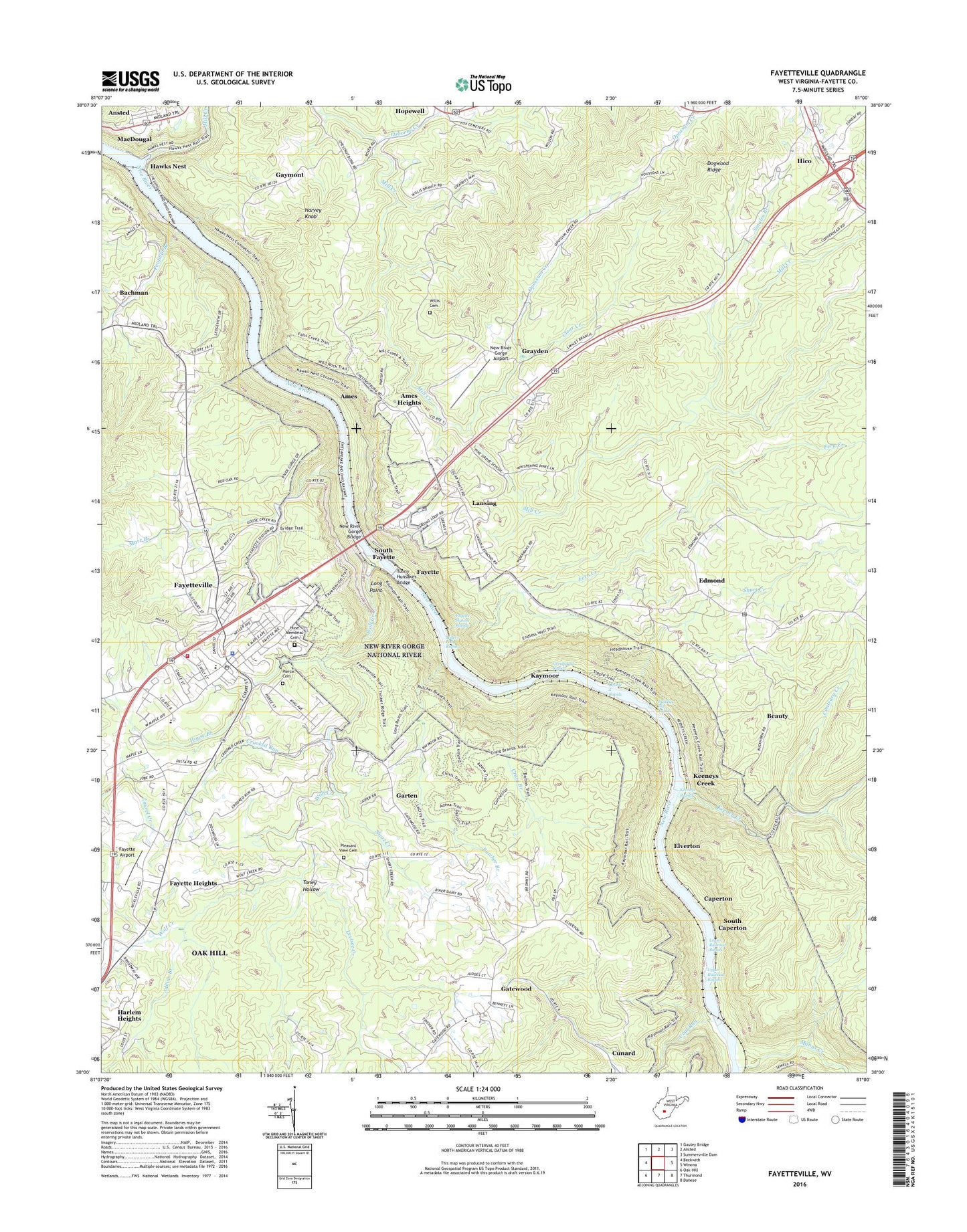
2023 topographic map quadrangle Fayetteville in the state of West Virginia. Scale: 1:24000. Based on the newly updated USGS 7.5' US Topo map series, this map is in the following counties: Fayette. The map contains contour data, water features, and other items you are used to seeing on USGS maps, but also has updated roads and other features. This is the next generation of topographic maps. Printed on high-quality waterproof paper with UV fade-resistant inks.
Quads adjacent to this one:
West: Beckwith
Northwest: Gauley Bridge
North: Ansted
Northeast: Summersville Dam
East: Winona
Southeast: Danese
South: Thurmond
Southwest: Oak Hill
This map covers the same area as the classic USGS quad with code o38081a1.
Contains the following named places: Adkins Branch, Altamont School, Ames, Ames Heights, Bachman, Beauty, Beauty Mountain Church, Boone, Bridge Haven Golf Club, Butcher Branch, Caperton, Carver, Clear Creek, Coal Run, Contrary Creek, Craig Branch, Crooked Run, Crooked Run School, Dogwood Ridge School, Double Z Rapids, Dudleys Dip Rapids, Duncan School, Edmond, Edmond Post Office, Elverton, Fayette, Fayette Airport, Fayette County, Fayette County Courthouse, Fayette County Sheriff's Office, Fayette Heights, Fayette Station Rapids, Fayetteville, Fayetteville Baptist Church, Fayetteville Elementary School, Fayetteville High School, Fayetteville Middle School, Fayetteville Police Department, Fayetteville Post Office, Fayetteville Presbyterian Church, Fayetteville Public Library, Fayetteville United Methodist Church, Fayetteville Volunteer Fire Department, Fern Creek, First Church of God, Friends Landing, Garten, Garten Census Designated Place, Gatewood, Gatewood Census Designated Place, Gatewood Elementary School, Gaymont, Goodhope Church, Grayden, Greyhound Rapids, Harlem Heights, Harvey Knob, Hawks Nest, Hawks Nest State Park, Hess School, Hico, Hico Census Designated Place, Hico Post Office, Historic Fayette Theatre, Hopewell Baptist Church, House Branch, Huse Memorial Cemetery, Jan - Care Ambulance Service Fayetteville, Janutola Park, Kaymoor, Kaymoor Number 1, Keeney Creek, Keeneys Creek, Keeneys Rapids, Lansing, Lansing Post Office, Levisee Creek, Locust Grove Church, Long Point, Lower Railroad Rapids, MacDougal, Manns Creek, Marr Branch, McKenney Church, Michigan, Mill Creek, Millers Folly Rapids, Mincar, New River Gorge Airport, New River Gorge Bridge, Newlyn, Nuttalburg, Nuttall Station, Oak Ridge, Opossum Creek, Osborne Creek, Pendleton School, Penfield Branch, Pierce Cemetery, Pine Grove, Pleasant Grove Church, Pleasant View Cemetery, Pleasant View Church, Short Creek, Smales Branch, South Caperton, South Fayette, South Nuttall, Sunday Road Church, Sunnyside, Toney Hollow, Town of Fayetteville, Tunny Hunsaker Bridge, Upper Railroad Rapids, Victory School, West Virginia Division of Forestry Fayette County Field Office, Whitney, Willis Cemetery, Wolf Creek, Wolf Creek School, ZIP Codes: 25837, 25840, 25862