MyTopo
Milton West Virginia US Topo Map
Couldn't load pickup availability
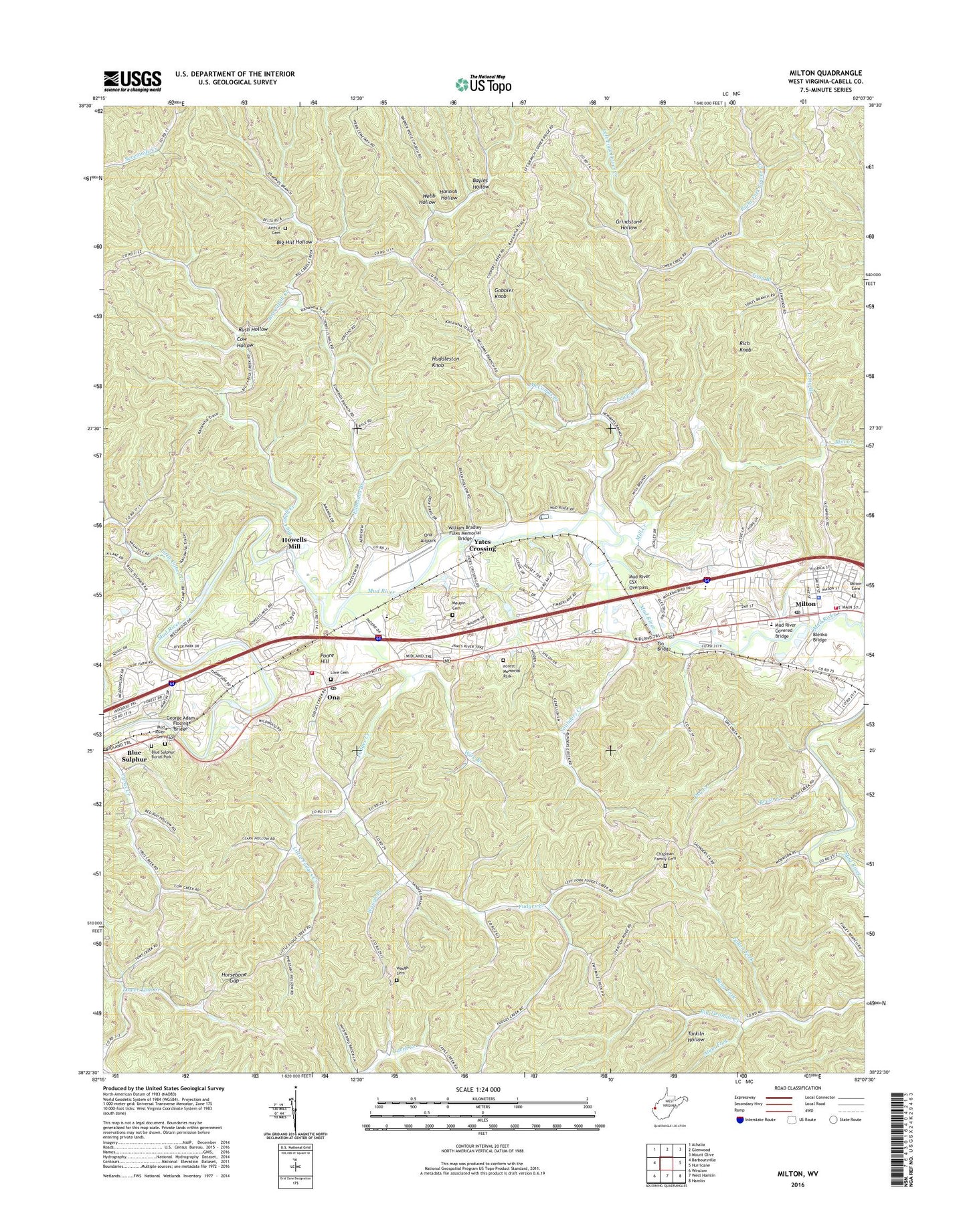
2023 topographic map quadrangle Milton in the state of West Virginia. Scale: 1:24000. Based on the newly updated USGS 7.5' US Topo map series, this map is in the following counties: Cabell. The map contains contour data, water features, and other items you are used to seeing on USGS maps, but also has updated roads and other features. This is the next generation of topographic maps. Printed on high-quality waterproof paper with UV fade-resistant inks.
Quads adjacent to this one:
West: Barboursville
Northwest: Athalia
North: Glenwood
Northeast: Mount Olive
East: Hurricane
Southeast: Hamlin
South: West Hamlin
Southwest: Winslow
This map covers the same area as the classic USGS quad with code o38082d2.
Contains the following named places: Alum Fork, Antioch Church, Arthur Cemetery, Bayles Hollow, Bethel Church, Bethesda United Methodist Church, Beulah Ann Church, Beulah Chapel, Big Cabell Creek, Big Hill Hollow, Blenko Bridge, Blue Sulphur, Blue Sulphur Burial Park, Brush Creek, Bryan Chapel, Cabell County, Cabell County Emergency Medical Services Station 1, Cabell County Sheriff's Office, Cabell Midland High School, Camp Arrowhead, Camp Guyandotte, Chapman Family Cemetery, Cow Hollow, Cyrus Creek Church, District 5, Dry Creek, Edmonds Branch, Fallen Fork, First United Methodist Church, Forest Memorial Park, Fudges Creek, George Adam Floding Bridge, Gobbler Knob, Grindstone Hollow, Hannah Hollow, Hatfield Lake Dam, Hebron Church, Horsebone Gap, Howells Mill, Huddleston Knob, Indian Meadows, Johns Branch, Kiwanivista Park, Lakeview Fishing Lake Dam, Left Fork Lower Creek, Little Cabell Creek, Little Fudges Creek, Long Branch, Love Cemetery, Lower Creek, Lower Creek Church, Malcolm Springs Heights, Maupin Cemetery, McComas Branch, Mill Creek, Milton, Milton Baptist Church, Milton Branch Cabell County Public Library, Milton Cemetery, Milton Elementary School, Milton High School, Milton Middle School, Milton Police Department, Milton Post Office, Milton Volunteer Fire Department Station 1, Mount Zion Church, Mud River Baptist Church, Mud River Cemetery, Mud River Covered Bridge, Mud River CSX Overpass, Ona, Ona Airpark, Ona Elementary School, Ona Industrial Park, Ona Middle School, Ona Post Office, Ona Volunteer Fire Department, Perry Morris Square, Pleasant Valley Church, Poore Hill, Pressley Ridge School at Grant Gardens, Rich Knob, Right Fork Lower Creek, Rolling Hills, Rush Hollow, Sang Fork, Saunders Creek, Sunrise Temple, Tarkiln Hollow, Tin Bridge, Tony Branch, Town of Milton, Warner Church, Waugh Branch, Waugh Cemetery, Webb Hollow, WEMM-FM (Huntington), William Bradley Fulks Memorial Bridge, Wire Branch, WPBY-TV (Huntington), WVWV-FM (Huntington), Yates Crossing, ZIP Codes: 25541, 25545