MyTopo
Wayne West Virginia US Topo Map
Couldn't load pickup availability
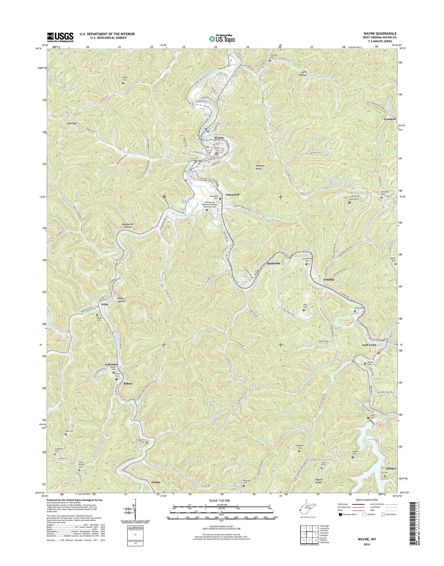
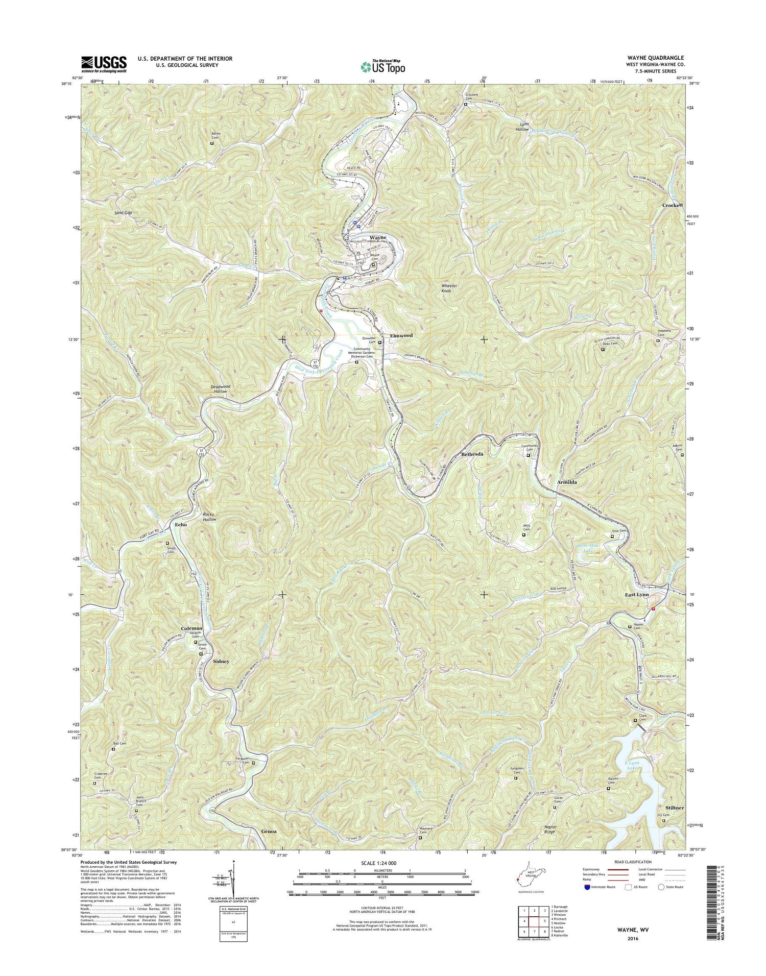
2019 topographic map quadrangle Wayne in the state of West Virginia. Scale: 1:24000. Based on the newly updated USGS 7.5' US Topo map series, this map is in the following counties: Wayne. The map contains contour data, water features, and other items you are used to seeing on USGS maps, but also has updated roads and other features. This is the next generation of topographic maps. Printed on high-quality waterproof paper with UV fade-resistant inks.
Quads adjacent to this one:
West: Prichard
North: Lavalette
Northeast: Winslow
East: Nestlow
Southeast: Kiahsville
South: Radnor
Southwest: Louisa
Contains the following named places: Adkins Cemetery, Armilda, Bailey Cemetery, Ball Cemetery, Bartram Branch, Battern Fork, Bethesda, Big Branch, Big Branch School, Big Lynn School, Booth Branch, Brush Creek, Camp Creek, Clark Cemetery, Coleman, Comfort Church, Community Cemetery, Community Memorial Gardens-Dickerson Cemetery, Crabtree Cemetery, Crockett, Crockett Cemetery, Deadwood Hollow, Dean Cemetery, Deephole Branch, East Fork Twelvepole Creek, East Lynn, East Lynn Dam, East Lynn Elementary School, East Lynn Post Office, East Lynn Volunteer Fire Department, Echo, Echo Church, Edds Branch, Elmwood, Elmwood Cemetery, Ferguson Cemetery, Flat Branch, Fraley Fork, Fry Cemetery, Garrett Creek School, Genoa Elementary School, Greenbrier Church, Greenbrier Creek, Hopewell Church, Jackson Cemetery, Joels Branch, Joels Branch Cemetery, Joels Branch School, Johnnys Branch, Kennedy Chapel, Kilpeck Branch, Lambert Branch, Laurel Creek, Left Fork Lynn Creek, Left Fork Wilson Creek, Lick Branch, Little Lynn Creek, Lucas Cemetery, Luster Fork, Lynn Creek, Lynn Hollow, Mam-Maw Lake, Maynard Cemetery, Meeks Branch, Middle Fork Wilson Creek, Mills Cemetery, Napier Cemetery, Newcomb Creek, Newcomb Creek Church, Onemile Creek, Patrick Creek, Patrick Creek Church, Petercave Branch, Ramey Cemetery, Right Fork Lynn Creek, Rockhouse Branch, Rocky Hollow, Sand Gap, Sidney, Smith Cemetery, Spurlock Church, Stephens Cemetery, Stiltner, Sycamore Branch, Sycamore School, Toms Creek, Toms Creek Church, Town of Wayne, Trace Fork, Twelvepole Valley Church, Twomile Creek, Twomile School, Vine Cemetery, Wayne, Wayne Cemetery, Wayne County, Wayne County Courthouse, Wayne County Sheriff's Office, Wayne High School, Wayne Middle School, Wayne Police Department, Wayne Post Office, Wayne Public Library, Wayne Volunteer Fire Department, West Fork Twelvepole Creek, West Virginia State Police Troop 5 - Wayne Detachment, Wheeler Knob, White Oak Fork, Wilson Creek, Wilson School, Wolf Creek, ZIP Code: 25570