MyTopo
Eau Claire West Wisconsin US Topo Map
Couldn't load pickup availability
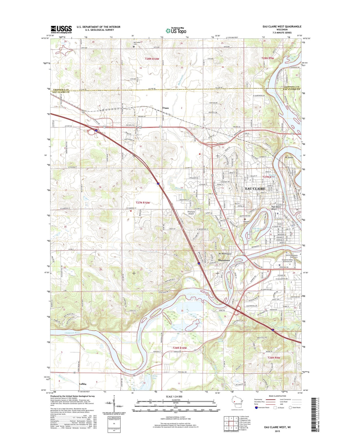
2022 topographic map quadrangle Eau Claire West in the state of Wisconsin. Scale: 1:24000. Based on the newly updated USGS 7.5' US Topo map series, this map is in the following counties: Eau Claire, Chippewa. The map contains contour data, water features, and other items you are used to seeing on USGS maps, but also has updated roads and other features. This is the next generation of topographic maps. Printed on high-quality waterproof paper with UV fade-resistant inks.
Quads adjacent to this one:
West: Elk Creek Lake
Northwest: Colfax South
North: Albertville
Northeast: Chippewa Falls
East: Eau Claire East
Southeast: Cleghorn
South: Mondovi NE
Southwest: Rock Falls
This map covers the same area as the classic USGS quad with code o44091g5.
Contains the following named places: Barstow School, Berghs Mobile Home Park, Big Dells Pond 5752, Cameron Park Playground, Carson Park, Charlotte's Berry Farm, Chippewa Valley Historical Museum, Chippewa Valley Montessori Charter School, Chippewa Valley Technical College, Chippewa Valley Technical College - West Campus, Christian Community Church, Church of the Nazarene, Concordia Evangelical Lutheran Church, Cooley Lake, Dells 1907C35 Dam, Dells Dam, Dells Hydro Generating Station, Delong Middle School, Eau Claire Academy, Eau Claire County Courthouse, Eau Claire County Hospital, Eau Claire County Jail, Eau Claire County Sheriff's Office, Eau Claire Fire and Rescue Station 9, Eau Claire Lutheran School, Eau Claire Police Department, Eau Claire Post Office, Eau Claire River, Eau Claire Wastewater Treatment Plant, Epiphany Evangelical Lutheran Church, Fire Station Number 4, First Baptist Church, First Congregational Church, First Evangelical Lutheran Church, Gemini Drive-In, Grace Lutheran Church, Gypsy Park, Half Moon Beach, Half Moon Lake 2.54, Half Moon Lake H 364 Dam, Halfmoon Lake, Halfmoon Park, Hobart Playground, Hobbs Ice Arena, Immanuel Lutheran High School, Jaquish Farms, Kaiser Field, Katherine Thomas Hall, Kessler Field, Lake Street United Methodist Church, Lakeshore Elementary School, Lakeview Cemetery, Little Niagara Creek, Little Red Elementary School, Longview School, Lowes Creek, Lufkin, Luther Hospital Heliport, Lutheran Church of the Good Shepherd, Maple Drive School, Mayo Health Systems Luther Hospital, McCombs Cemetery, Mill Run Golf Course, Mount Simon, Mount Simon Park, Mount Washington, Mount Washington Elementary School, Mount Washington Sanatorium, New Hope Christian School, Newall Playground, Northwest Reading Clinic, Oak Ridge Village Mobile Home Park, Oxford Avenue School, Pentecostal Assembly Church, Pine Edge Mobile Home Park, Pleasant Hill Farms, Plymouth United Church of Christ, Porters Mills, Prairieview School, Pritchard Field, Putnam Hall, Putnam Heights Elementary School, Randall Elementary School, Randall Park, Randall Playground, Riverview School, Rod and Gun Park, Roosevelt Elementary School, Roosevelt Playground, Sacred Heart Hospital, Saint Bedes Academy, Saint James Catholic School, Saint James the Greater Catholic Church, Saint Patrick School, Saint Patricks Roman Catholic Church, Second Avenue School, Shawtown, Sherman Creek, Sherman Creek Park, Sherman Elementary School, Sherman School, Silver Bow Farm, Silver Mine Hill Ski Jump, Silver Spring, Silvermine Farms, Sky Park Industrial Center, Sorenson Dairy Farm, Stahlbusch Farms, Taylor Creek, The Church of Jesus Christ of Latter Day Saints, Town of Union, Township Fire Department Station 3 Union, Truax, Truax Church, Truax School, Union, United Christians New World, Unity Christ Center, University of Wisconsin - Eau Claire, University of Wisconsin - Eau Claire Police Department, WEUZ-AM (Eau Claire), William D McIntyre Library, WYDR-FM (Eau Claire), ZIP Codes: 54701, 54703