MyTopo
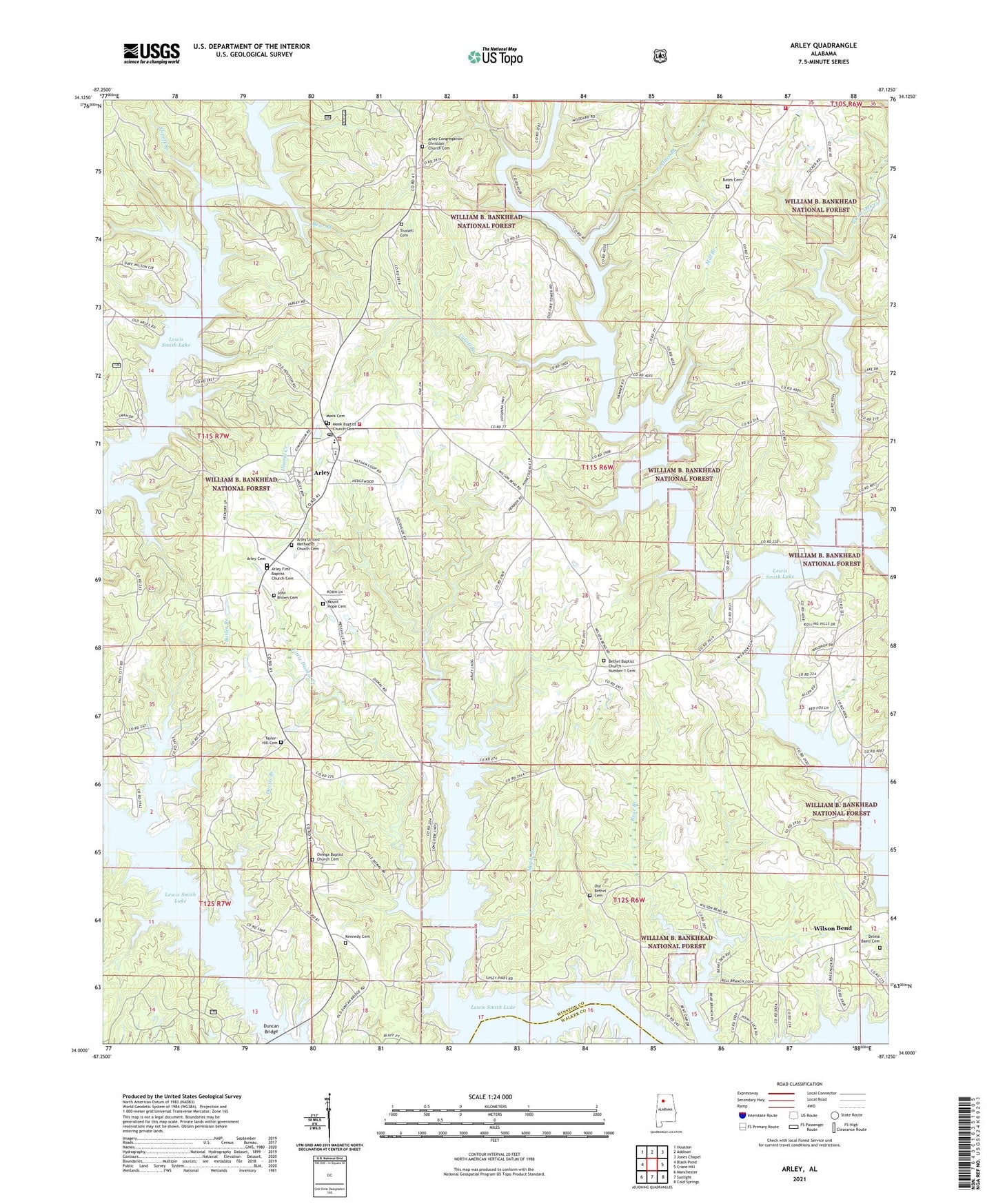
Arley Alabama US Topo Map
Couldn't load pickup availability
Also explore the Arley Forest Service Topo of this same quad for updated USFS data
2024 topographic map quadrangle Arley in the state of Alabama. Scale: 1:24000. Based on the newly updated USGS 7.5' US Topo map series, this map is in the following counties: Winston, Walker. The map contains contour data, water features, and other items you are used to seeing on USGS maps, but also has updated roads and other features. This is the next generation of topographic maps. Printed on high-quality waterproof paper with UV fade-resistant inks.
Quads adjacent to this one:
West: Black Pond
Northwest: Houston
North: Addison
Northeast: Jones Chapel
East: Crane Hill
Southeast: Cold Springs
South: Sunlight
Southwest: Manchester
This map covers the same area as the classic USGS quad with code o34087a2.
Contains the following named places: Anton School, Arley, Arley Cemetery, Arley Church of Christ, Arley Congregation Christian Church Cemetery, Arley First Baptist Church, Arley First Baptist Church Cemetery, Arley Landing, Arley Police Department, Arley Post Office, Arley School, Arley United Methodist Church, Arley United Methodist Church Cemetery, Arley Volunteer Fire Department Station 1, Arley Volunteer Fire Department Station 2, Bates Cemetery, Bear Branch, Bethel Baptist Church Number 1 Cemetery, Bethel Church, Bethel School, Braden Post Office, Butler Branch, Clear Creek, Crooked Creek, Cutoff Branch, Delma Baird Cemetery, Devils Branch, Dismal Creek, Dismal Post Office, Duncan Bridge, Duncan Bridge Marina, Farley Branch, Greens Chapel School, Helicon Fire Department, Hueys Marina, John Brown Cemetery, Kennedy Cemetery, Lewis Smith Lake, Lindley School, Little Dismal Creek, Maple Branch, Maple Branch School, McCellan Chapel School, Meek Baptist Church, Meek Baptist Church Cemetery, Meek Cemetery, Meek Elementary School, Meek High School, Meek Lookout Tower, Mellville Post Office, Mellville School, Melville, Mill Branch, Mount Hope Cemetery, Nathan, Nathan School, New Hope School, Old Bethel Cemetery, Old Bethel Church, Old Union School, Omega Baptist Church, Omega Baptist Church Cemetery, Panther Branch, Pine Ridge School, Piney Ridge Church, Piney Ridge Mine, Poplar Springs School, Robertson Chapel, Slipoff Branch, Smith School, Taylor-Hill Cemetery, Tiger Field, Town of Arley, Trussell Cemetery, Union Grove School, White Oak Creek, Wilson Bend, Wilson Bend Mine, ZIP Code: 35541