MyTopo
Carbon Hill Alabama US Topo Map
Couldn't load pickup availability
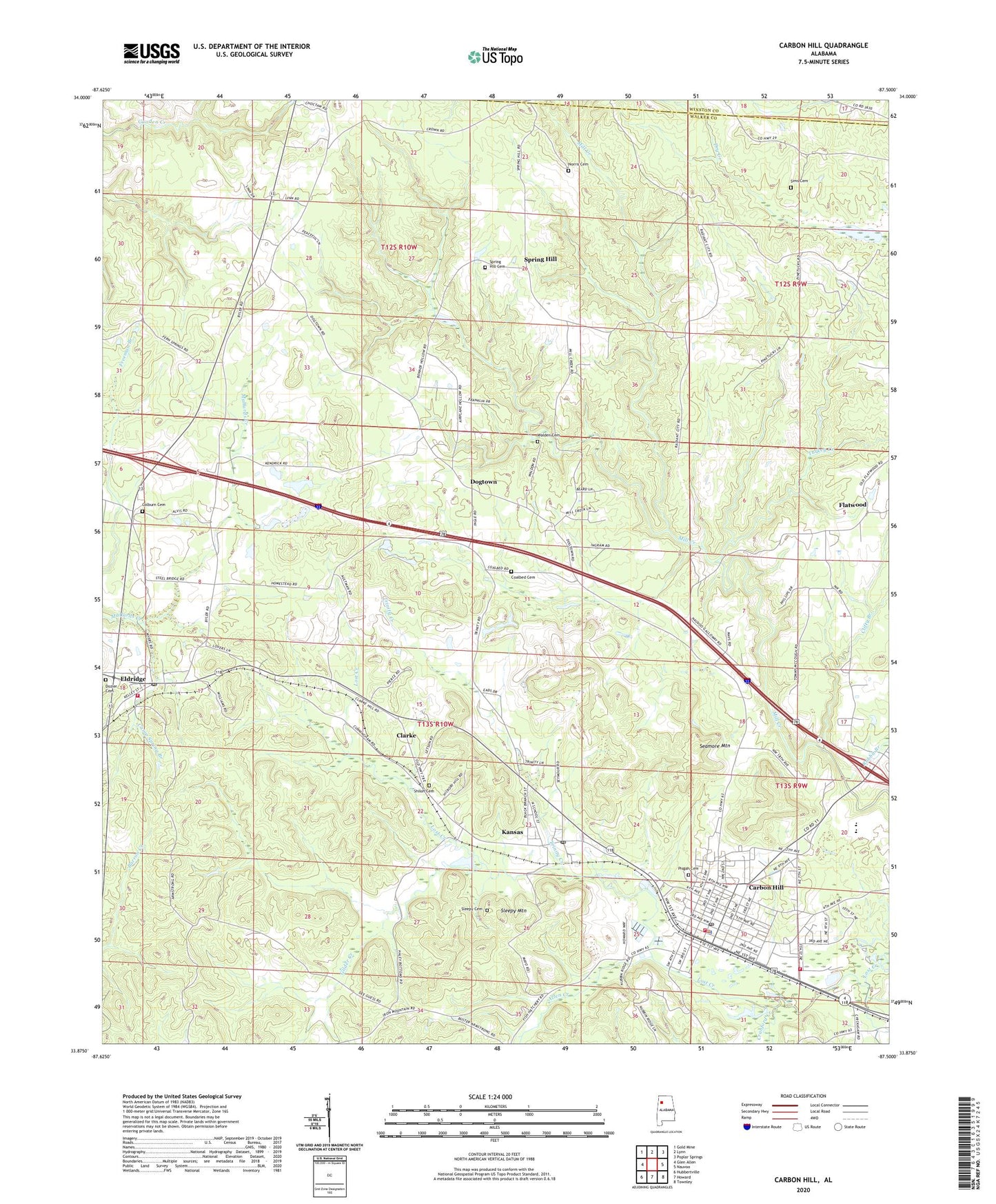
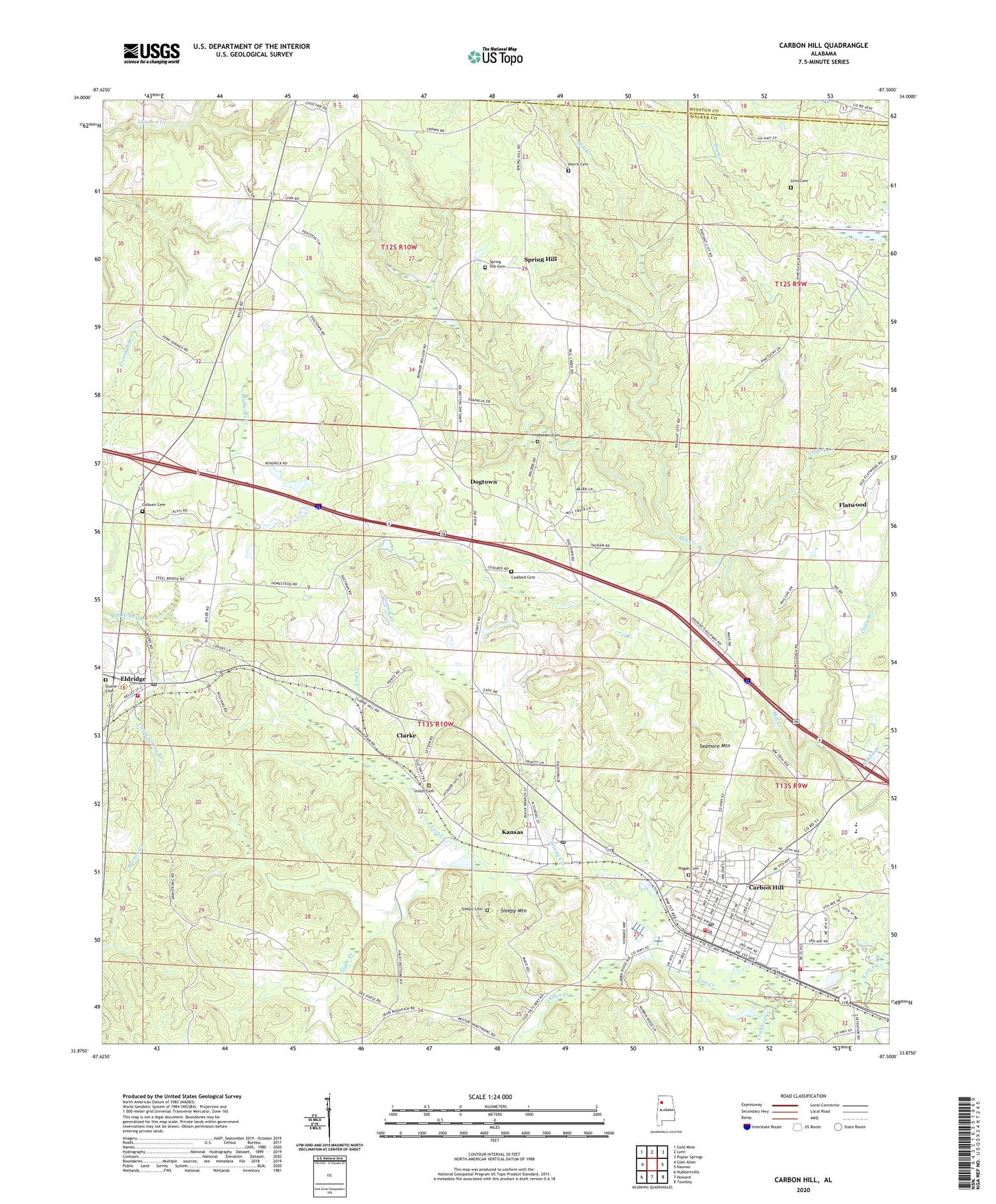
2024 topographic map quadrangle Carbon Hill in the state of Alabama. Scale: 1:24000. Based on the newly updated USGS 7.5' US Topo map series, this map is in the following counties: Walker, Winston. The map contains contour data, water features, and other items you are used to seeing on USGS maps, but also has updated roads and other features. This is the next generation of topographic maps. Printed on high-quality waterproof paper with UV fade-resistant inks.
Quads adjacent to this one:
West: Glen Allen
Northwest: Gold Mine
North: Lynn
Northeast: Poplar Springs
East: Nauvoo
Southeast: Townley
South: Howard
Southwest: Hubbertville
This map covers the same area as the classic USGS quad with code o33087h5.
Contains the following named places: Allen Creek, Banner Mine, Baptist Childrens Home, Bible Missionary Church, Bynum Drift Mine, Camp Spring Branch, Carbon Hill, Carbon Hill Church of Christ, Carbon Hill Division, Carbon Hill Elementary School, Carbon Hill Grammar School, Carbon Hill High School, Carbon Hill Junior High School, Carbon Hill Mine, Carbon Hill National Fish Hatchery, Carbon Hill Police Department, Carbon Hill Post Office, Carbon Hill Presbyterian Church, Carbon Hill Volunteer Fire Department, Carbon Hill Volunteer Rescue Squad, Church of Christ, City of Carbon Hill, Clarke, Clifty Branch, Coalbed Cemetery, Colburn Cemetery, Cranford Creek, Dogtown, Dozier Cemetery, Eldridge, Eldridge Church of Christ, Eldridge Gas Field, Eldridge Junior High School, Eldridge Post Office, Eldridge Volunteer Fire Department, Elk River Shaft Mine, Elliots Mine, First Methodist Church, Flatwood, Galloway, Galloway Mine Number Eleven, Galloway Mine Number Six, Galloway Mines, Gilder Creek, Grant Christian Methodist Episcopal Chapel, Guthrie Mine, Harris Slope Mine, Hope Mine, Hope-Galloway Mine, Hopewell Church, Iron Mountain School, Jagger Mine Number Two, Jagger Mines, Jays Lake, Jays Lake Dam, Kansas, Kansas Baptist Church, Kansas Post Office, McGough New Slope Mine, Monroe Mine, Nauvoo Mine, Nauvoo Number 1 Mine, New Bethany Church, New Life Pentecostal Church, Norris Cemetery, Old Glady Branch, Old Union Primitive Baptist Church, Pisgah Cemetery, Rabbit Branch, Radiant City Church, Radiant Mine, Seamore Mountain, Shiloh Cemetery, Sides School, Sims Cemetery, Sleepy Cemetery, Sleepy Mountain, Slicklizzard, Spring Hill, Spring Hill Cemetery, Spring Hill Church, Spring Hill School, Standard Mine, Thornberry Drift Mine, Town of Eldridge, Town of Kansas, Trinity Creek, Truck Mine, Turkey Creek, Wagon Mine, Walden Cemetery, Waldon Mine, Whitson Number 1 Mine, Yateman Mines