MyTopo
Dugout Valley Alabama US Topo Map
Couldn't load pickup availability
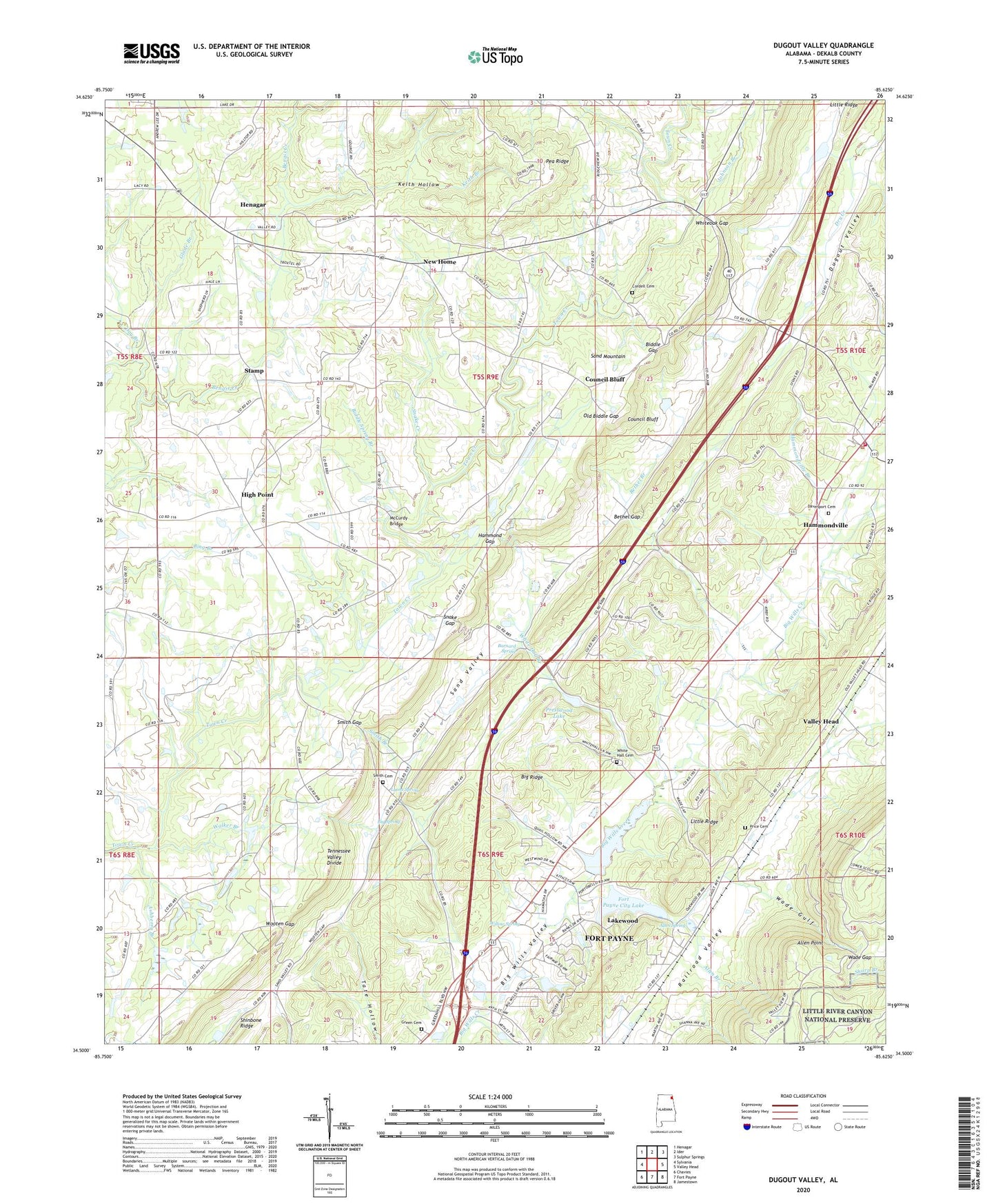
2024 topographic map quadrangle Dugout Valley in the state of Alabama. Scale: 1:24000. Based on the newly updated USGS 7.5' US Topo map series, this map is in the following counties: DeKalb. The map contains contour data, water features, and other items you are used to seeing on USGS maps, but also has updated roads and other features. This is the next generation of topographic maps. Printed on high-quality waterproof paper with UV fade-resistant inks.
Quads adjacent to this one:
West: Sylvania
Northwest: Henagar
North: Ider
Northeast: Sulphur Springs
East: Valley Head
Southeast: Jamestown
South: Fort Payne
Southwest: Chavies
This map covers the same area as the classic USGS quad with code o34085e6.
Contains the following named places: Allen Branch, Allen Memorial Baptist Church, Allen Point, Allen Spring, Allen Switch, Ashberry Branch, Barnard Spring, Bethel Branch, Bethel Church, Bethel Gap, Biddle Gap, Biddle Spring Branch, Big Spring, Blackburns Store, Chambers Dam, Chambers Lake, Church of God, Cordell, Cordell Cemetery, Council Bluff, Council Bluff School, Cranes Store, Davenport Cemetery, Day Branch, Fort Payne City Lake, Fort Payne Dam, Glade Branch, Green Cemetery, Hammond Gap, Hammondville, Hammondville Branch, Hammondville Police Department, Hammondville Volunteer Fire Department, Hawkins Chapel, Hawkins Chapel School, Hawkins Dam, Hawkins Lake, Henagar Division, High Point, High Point Church of God, High Point School, House of Prayer Church, Johnson Branch, Keith Branch, Keith Hollow, Kings Chapel, Lakewood, Lea Chapel, Lea Chapel School, Lyons Spring, Mays Gulf, McCurdy Bridge, Mount Olive Church, New Home, New Home School, Old Biddle Gap, Pea Ridge, Pea Ridge Church, Pea Ridge School, Pells Chapel, Pine Grove Church, Prestwood Dam, Prestwood Lake, Price Cemetery, Smith Branch, Smith Cemetery, Smith Gap, Snake Creek, Snake Gap, Stamp, Terrapin Hills Golf Estates, Thomas Branch, Town of Hammondville, Wade Gap, Wade Gulf, Walker Branch, Welcome View Church, West Fork Bengis Creek, White Hall Branch, White Hall Cemetery, White Hall Church, Whiteoak Gap, Willow Spring, Wills Lake, Wooten Gap, ZIP Code: 35968