MyTopo
Guntersville Dam Alabama US Topo Map
Couldn't load pickup availability
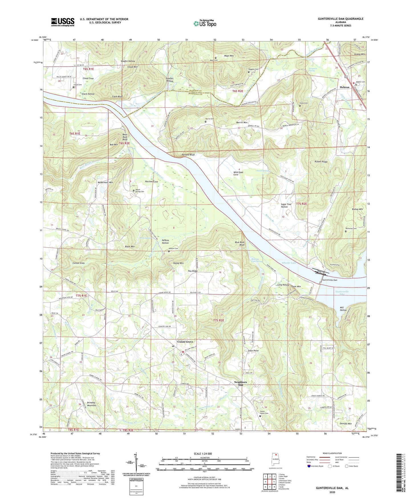
2024 topographic map quadrangle Guntersville Dam in the state of Alabama. Scale: 1:24000. Based on the newly updated USGS 7.5' US Topo map series, this map is in the following counties: Marshall, Madison. The map contains contour data, water features, and other items you are used to seeing on USGS maps, but also has updated roads and other features. This is the next generation of topographic maps. Printed on high-quality waterproof paper with UV fade-resistant inks.
Quads adjacent to this one:
West: Newsome Sinks
Northwest: Farley
North: New Hope
Northeast: Grant
East: Mount Carmel
Southeast: Guntersville
South: Arab
Southwest: Hulaco
This map covers the same area as the classic USGS quad with code o34086d4.
Contains the following named places: Allens Bar, Bean Rock, Bean Rock Bluff, Bean Rock Creek, Bean Rock Ferry, Bean Rock Landing, Bean Rock School, Beech Spring, Beech Spring Cemetery, Beech Spring Church, Benson Branch, Black Center, Black Mountain, Bloomfield, Blowing Cave Spring, Blue Rock Bluff, Blue Rock Landing, Bob Mountain, Boggess Cemetery, Cave Mountain, Cave Mountain Small Wild Area, Clark Bluff, Clark Hollow, Cloud Cemetery, Cloud Cove Church, Cloud Mountain, Cloud School, Coal Landing, Coles Bend Bar, Cotton Sinks, Daniel Spring, Fearn Branch, Ferguson Farms, Ferguson Spring, Ferns Quarter, Flat Rock School, Fosters Landing, Georgia Mountain, Guntersville Dam, Guntersville Dam Landing Field, Guntersville Lake, Hambrick Hollow, Haney Mountain, Harding Chapel, Hebron, Hebron Church, Hebron School, Hebron Volunteer Fire Department, Hills Chapel, Hines Cemetery, Honey Ferry, Honey Landing, Johnson, Lamont, Lamont School, Liberty Grove School, Little Paint Rock Creek, Long Hollow, Long Hollow Branch, Martin Farm, Mayo Cemetery, Mayo Mountain, McDermott Mountain, Merrill Mountain, Merrill Reservation, Mill Hollow, Mobbs Church, Mobbs School, Morris Cemetery, Mount Hebron Baptist Church, Mount View Church, Nearen Cemetery, Neighbors Mill, Paint Rock Landing, Paint Rock River, Painted Bluff, Parches Cove, Patterson Cemetery, Pea Ridge, Peachtree Creek, Perkins Hollow, Pigeon Roost Creek, Robertson Reservation, Russell Ridge, Scott Branch, Shoal Creek, Snow Point, Speers Landing, Stewart Hollow, Sugar Tree Hollow, Sweet Home Baptist Church, Sweet Home Cemetery, Tacket Branch, Town of Union Grove, Union Chapel Church, Union Grove, Union Grove Division, Union Grove Junior High School, Union Grove Post Office, Union Grove Volunteer Fire Department, Upton, Vaughn Hollow, Walker Cemetery, Wild Goat Cove, Wolf Creek