MyTopo
Hulaco Alabama US Topo Map
Couldn't load pickup availability
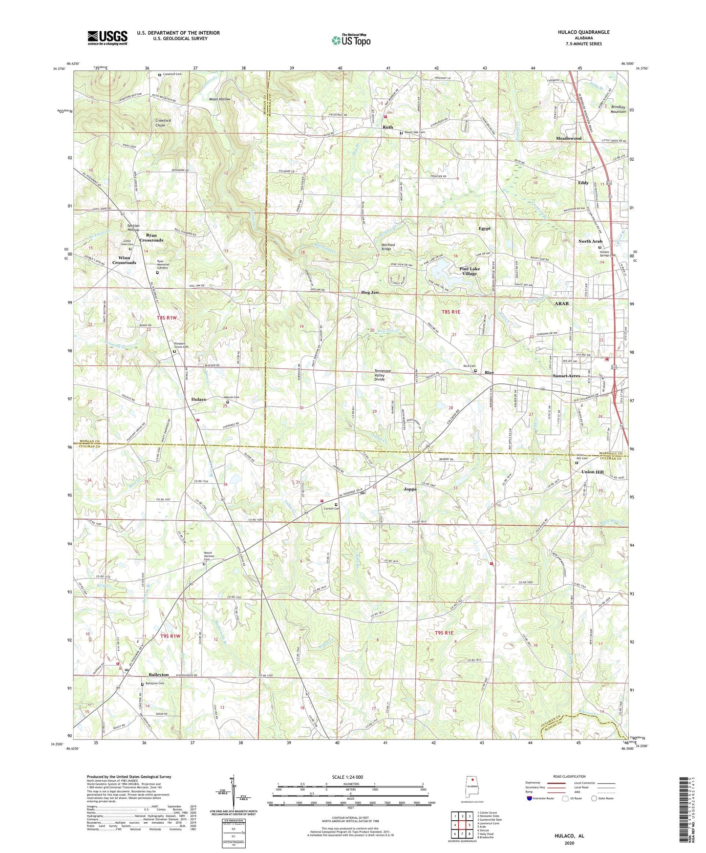
2024 topographic map quadrangle Hulaco in the state of Alabama. Scale: 1:24000. Based on the newly updated USGS 7.5' US Topo map series, this map is in the following counties: Cullman, Marshall, Morgan, Blount. The map contains contour data, water features, and other items you are used to seeing on USGS maps, but also has updated roads and other features. This is the next generation of topographic maps. Printed on high-quality waterproof paper with UV fade-resistant inks.
Quads adjacent to this one:
West: Lawrence Cove
Northwest: Center Grove
North: Newsome Sinks
Northeast: Guntersville Dam
East: Arab
Southeast: Brooksville
South: Holly Pond
Southwest: Simcoe
This map covers the same area as the classic USGS quad with code o34086c5.
Contains the following named places: Adams Poultry Farms, Arab Country Club, Arab Fire Department, Arab Junior High School, Baileyton, Baileyton Cemetery, Baileyton Junior High School, Baileyton Post Office, Baileyton United Methodist Church, Baileyton Volunteer Fire Department Station 1, Baileyton-Joppa Division, Berry Creek, Bobby Briscoe Farms, Corinth East Baptist Church, Corinth East Baptist Church Cemetery, Cranford Branch, Crawford Cemetery, Crawford Chute, Eddy, Eddy Baptist Church, Egypt, Gilliam Creek, Gilliam Springs Baptist Church, Gilliam Springs Baptist Church Cemetery, Grandiflora Church of Christ, Harvells Store, Hebron Cemetery, Hebron Church of Christ, Hilltop Church, Hog Branch, Hog Jaw, Hog Jaw Creek, Hulaco, Hulaco School, Independent Church, John H Burden Dairy, Joppa, Joppa Census Designated Place, Joppa Church of God, Joppa Creek, Joppa Junior High School, Joppa Post Office, Joppa United Methodist Church, Joppa Volunteer Fire Department Station 1, Joppa Volunteer Fire Department Station 2, King Branch, Lakeview Farms, Liberty Church, Little Vine Cemetery, Little Vine Primitive Baptist Church, May Apple, Meadowood, Mill Pond Bridge, Mill Pond Creek, Moon Hollow, Mount Herman School, Mount Hermon Baptist Church, Mount Hermon Missionary Baptist Church Cemetery, Mount Oak Methodist Church, Mount Oak Methodist Church Cemetery, New Jerusalem Baptist Church, Normal Industrial and Collegiate Institute, North Arab, Old Union Hill Methodist Cemetery, Open Door Christian Fellowship Church, Perkins Creek, Pine Lake, Pine Lake Dam, Pine Lake Village, Pleasant Grove Cemetery, Pleasant Grove Methodist Church, Pleasant Valley Church, Rice, Rice Cemetery, Rice School, Riley Maze Creek, Ruth, Ruth Baptist Church, Ruth School, Ruth Volunteer Fire Department, Ryan Baptist Church, Ryan Cemetery, Ryan Crossroads, Ryan High School, Sunset Acres, Tibb Creek, Town of Baileyton, Tri - County Volunteer Fire Department, Union Hill, Union Hill Methodist Church, Warrior Creek, Westside Baptist Church, Winn Crossroads, Wolf Creek, Yates Creek, ZIP Codes: 35016, 35087