MyTopo
Lawrence Cove Alabama US Topo Map
Couldn't load pickup availability
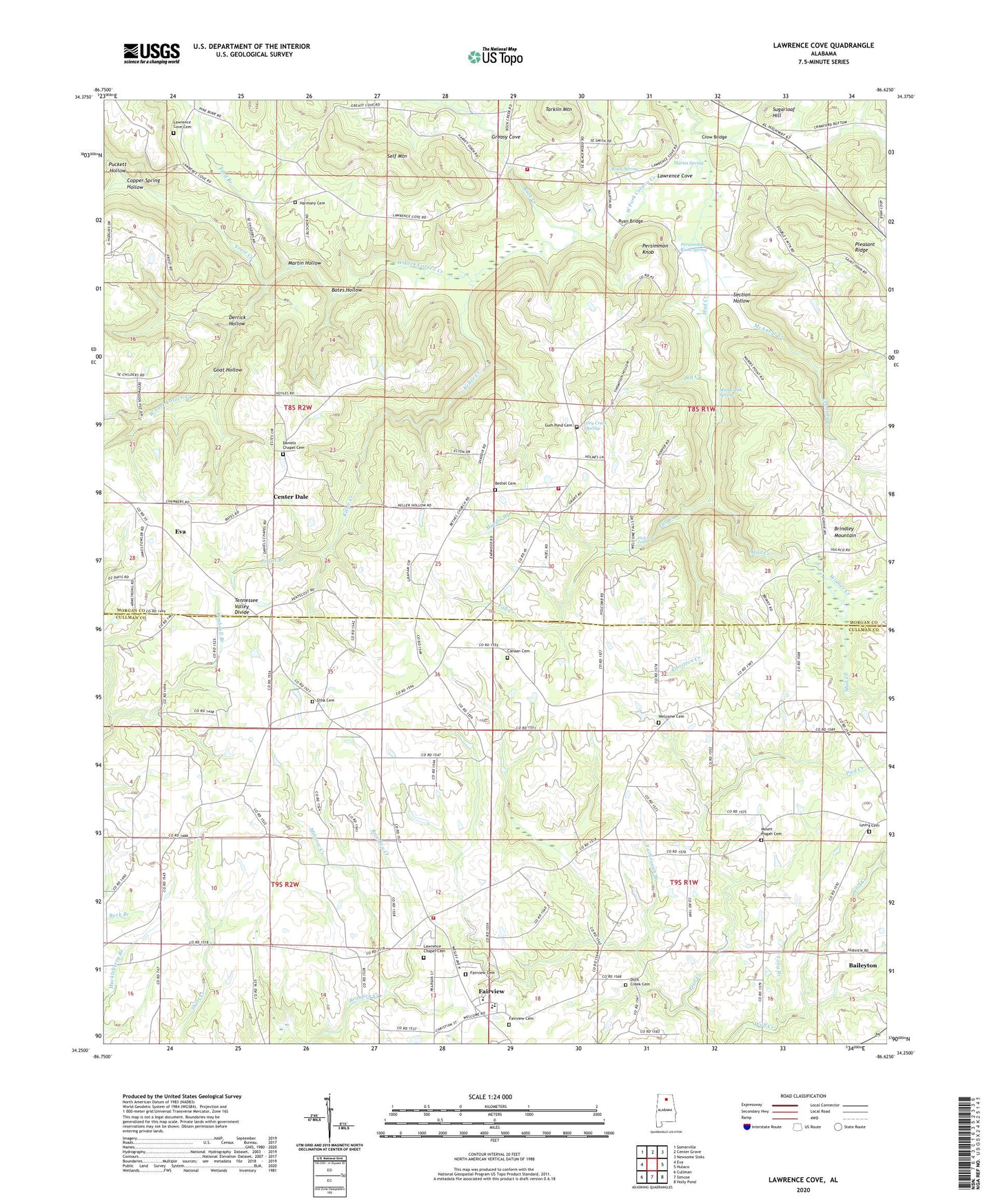
2024 topographic map quadrangle Lawrence Cove in the state of Alabama. Scale: 1:24000. Based on the newly updated USGS 7.5' US Topo map series, this map is in the following counties: Morgan, Cullman. The map contains contour data, water features, and other items you are used to seeing on USGS maps, but also has updated roads and other features. This is the next generation of topographic maps. Printed on high-quality waterproof paper with UV fade-resistant inks.
Quads adjacent to this one:
West: Eva
Northwest: Somerville
North: Center Grove
Northeast: Newsome Sinks
East: Hulaco
Southeast: Holly Pond
South: Simcoe
Southwest: Cullman
This map covers the same area as the classic USGS quad with code o34086c6.
Contains the following named places: Albritton Creek, Antioch Methodist Church, Bates Hollow, Bethel - Gum Pond Volunteer Fire Department, Bethel Cemetery, Bethel United Methodist Church, Canaan Cemetery, Canaan Church, Center Dale, Center Dale School, Copper Spring Hollow, County Line, County Line School, Crawford Spring Number 4, Crossroads Church, Crow Bridge, Daniels Chapel Baptist Church, Daniels Chapel Cemetery, Derrick Hollow, Dry Creek, Dry Creek Spring, Duck Creek Cemetery, Duck Creek Primitive Baptist Church, Etha Baptist Church, Etha Baptist Church Cemetery, Eva Division, Fairview, Fairview Cemetery, Fairview First Baptist Church Cemetery, Fairview High School, Fairview United Methodist Church, Fairview Volunteer Fire and Rescue Station 2, Fall Creek, First Baptist Church of Fairview, Ford Branch, Friendship Church, Frost Creek, Goat Hollow, Greasy Cove, Gum Pond, Gum Pond Cemetery, Gum Pond Primitive Baptist Church, Gum Pond School, Harmony Cemetery, Harmony Primitive Baptist Church, Herring Branch, Keller Creek, Kennedy Creek, Kimbrell Branch, Lawrence Chapel Cemetery, Lawrence Chapel Methodist Episcopal Church, Lawrence Cove, Lawrence Cove Baptist Church, Lawrence Cove Cemetery, Lawrence Cove School, Long Branch, Lystra Baptist Church, Lystra Baptist Church Cemetery, Macedonia Church of Christ, Mardis Branch, Martin Hollow, Martin Spring, McAnear Creek, Minnow Creek, Mount Olive Church, Mount Pisgah Cemetery, Mount Pisgah School, Mount Pisgah Upper Cumberland Presbyterian Church, Mud Creek, Mud Creek Spring, Pentecostal Church, Persimmon Knob, Persimmon Knob Spring, Pied Creek, Pleasant Ridge, Pleasant Ridge Church, Pruitt Branch, Puckett Hollow, Roan Spring, Rock Creek, Rock Creek Baptist Church, Rock Creek Volunteer Fire Department, Ryan Bridge, Section Hollow, Self Mountain, Springer Church, Sugarloaf Hill, Town of Fairview, Welcome Baptist Church, Welcome Cemetery, Welcome Falls, Widner Creek, Yarbrough Branch, ZIP Codes: 35019, 35621