MyTopo
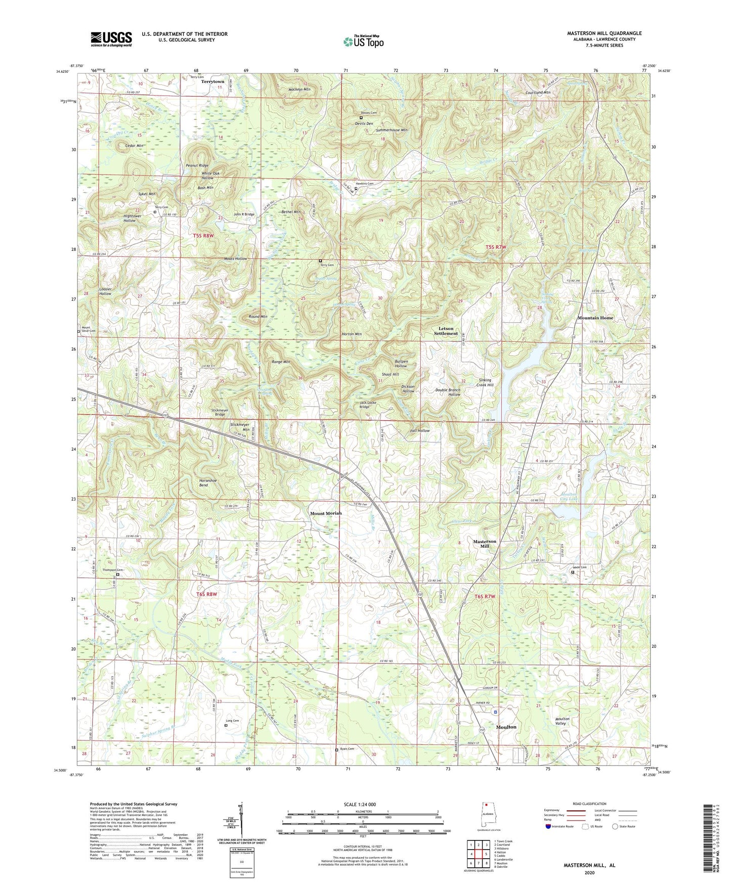
Masterson Mill Alabama US Topo Map
Couldn't load pickup availability
2024 topographic map quadrangle Masterson Mill in the state of Alabama. Scale: 1:24000. Based on the newly updated USGS 7.5' US Topo map series, this map is in the following counties: Lawrence. The map contains contour data, water features, and other items you are used to seeing on USGS maps, but also has updated roads and other features. This is the next generation of topographic maps. Printed on high-quality waterproof paper with UV fade-resistant inks.
Quads adjacent to this one:
West: Hatton
Northwest: Town Creek
North: Courtland
Northeast: Hillsboro
East: Caddo
Southeast: Oakville
South: Moulton
Southwest: Landersville
Contains the following named places: A Jones Mill, Alexander School, Bash Mountain, Bear Branch, Bethel Mountain, Bluff Spring, Borden Creek, Bridge Creek, Bullpen Hollow, Byars Cemetery, Cane Creek, Cedar Mountain, Clear Fork, Cold Spring Branch, Corinth Church, Crooked Creek, Crow Branch, Devils Den, Dickson Hollow, Doney Branch, Dossey Cemetery, Double Branch Hollow, Early Branch, Eddy Creek, Fair Haven Church, Fall Hollow, Grahams Race Track, Grandma Spring, Greg's Ambulance Service, Harmony Church, Hawkins Cemetery, Hightower Hollow, Horseshoe Bend, Horton Mountain, Horton Spring, Jack Locke Bridge, John C Terry Cemetery, John R Bridge, Jones Chapel, Key Branch, Kimo School, Lawrence County, Lawrence County Sheriff's Office, Letson Settlement, Liberty Church, Long Cemetery, Longtown, Loosier, Loosier Church of Christ, Loosier School, Mackeys Mountain, Masterson Church, Masterson Mill, Masterson Mill Lake Dam, Masterson School, Millie Branch, Moats Hollow, Moore Creek, Moulton City Lake, Moulton Valley, Moulton Water Plant, Mount Moriah, Mount Moriah Methodist Church, Mount Moriah School, Mount Olive Cemetery, Mountain Home, Mountain Home School, Muddy Fork, Muddy Prong, New Bethel Church, New Hope Church, New Hope School, New Liberty Church, Old Bethel Church, Peanut Ridge, Pine Mountain Church, Poplar Spring, Range Mountain, Rocky Branch, Round Mountain, Rutherford Creek, Salem Church, Salem School, Shoot Hill, Sinking Creek, Sinking Creek Hill, Sinking Creek Spring, Smyrna Baptist Church, Spout Spring, Stickmeyer Bridge, Stickmeyer Mountain, Sulphur Spring Branch, Summerhouse Mountain, Sykes Mountain, Terry Cemetery, Terrytown, Thompson Cemetery, Trace Ford, Turkey Creek, Wade Cemetery, Wade Creek, Walker Creek, White Oak Hollow, Yarboro Mill