MyTopo
Maysville Alabama US Topo Map
Couldn't load pickup availability
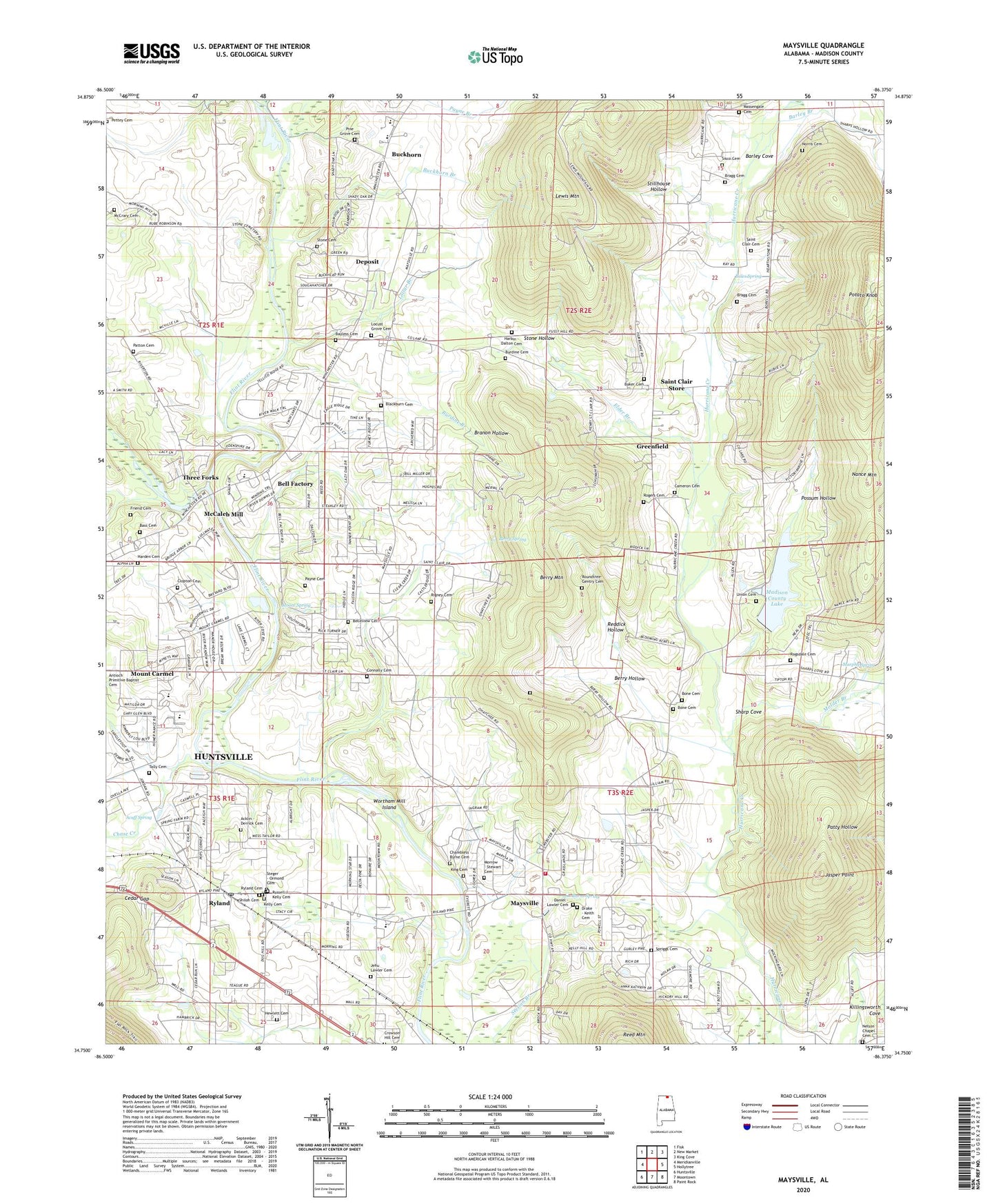
2024 topographic map quadrangle Maysville in the state of Alabama. Scale: 1:24000. Based on the newly updated USGS 7.5' US Topo map series, this map is in the following counties: Madison. The map contains contour data, water features, and other items you are used to seeing on USGS maps, but also has updated roads and other features. This is the next generation of topographic maps. Printed on high-quality waterproof paper with UV fade-resistant inks.
Quads adjacent to this one:
West: Meridianville
Northwest: Fisk
North: New Market
Northeast: King Cove
East: Hollytree
Southeast: Paint Rock
South: Moontown
Southwest: Huntsville
This map covers the same area as the classic USGS quad with code o34086g4.
Contains the following named places: Acklin - Derrick Cemetery, Acuff Spring, Baker Cemetery, Bales Spring, Barley Branch, Barley Cove, Bell Factory, Belleview Cemetery, Berry Hollow, Berry Mountain, Berry Spring, Blackburn Cemetery, Blackwell, Bone Cemetery, Bragg Cemetery, Branon Hollow, Brier Fork Church, Brier Fork Flint River, Brier Fork School, Buckhorn, Buckhorn Branch, Buckhorn High School, Burdine Branch, Burdine Cemetery, Burns Spring, Cameron Methodist Church, Cedar Gap, Cedar Grove Church, Central Junior High School, Central Volunteer Fire Department Station 1, Central Volunteer Fire Department Station 2, Central Volunteer Fire Department Station 3, Challenge Reservation, Chambless - Byrne Cemetery, Chase Creek, Clopton Cemetery, Connally Cemetery, Crowson Hill Cemetery, Daniel - Lawler Cemetery, Deposit, Drake - Keith Cemetery, Elder Branch, Fellowship Church, Flint Church, Flint Ridge Farm, Greenfield, Greenfield Church, Harbin - Dalton Cemetery, Hewlett Cemetery, Huntsville Equitation School, Hurricane Chapel, Hurricane Church, Hurricane Grove Church, Hurricane School, Jasper Point, Jehu Lawler Cemetery, Jones Memorial Church, Jordan Cemetery, Kelly Cemetery, Killingsworth School, Lewis Mountain, Locust Grove Baptist Church, Locust Grove Cemetery, Lollar Branch, Madison County Lake, Madison County Public Lake Dam, Massengale Cemetery, Maysville, Maysville Post Office, McCaleb Mill, McCrary Cemetery, McNutty Reservation, Millers Mill, Molder, Molder Branch, Moore Spring, Morning Star Church, Morrow - Stewart Cemetery, Mount Carmel, Mount Carmel School, Mountain Fork, Murphy Spring, Nance Mountain, Nelson Chapel Cemetery, New Flint Church, New Market Division, Norris Cemetery, Patton Cemetery, Pilgrim Rest Church, Pine Grove Cemetery, Pine Grove School, Possum Hollow, Potato Knob, Ragsdale Cemetery, Reddick Hollow, Rigney Cemetery, Riverton Junior High School, Rogers Cemetery, Roundtree-Gentry Cemetery, Russell J Kelly Cemetery, Ryland, Ryland Cemetery, Ryland Post Office, Saint Clair Cemetery, Saint Clair Store, Saint Paul Church, Sharp Cove, Shiloh Church, Sisco Cemetery, Spriggs Cemetery, Steger - Ormond Cemetery, Stiles Chapel, Stillhouse Hollow, Stone Cemetery, Stone Hollow, Tally Cemetery, Three Forks, Union Cemetery, Wear Chapel, Wortham Mill Island