MyTopo
Fort Huachuca Arizona US Topo Map
Couldn't load pickup availability
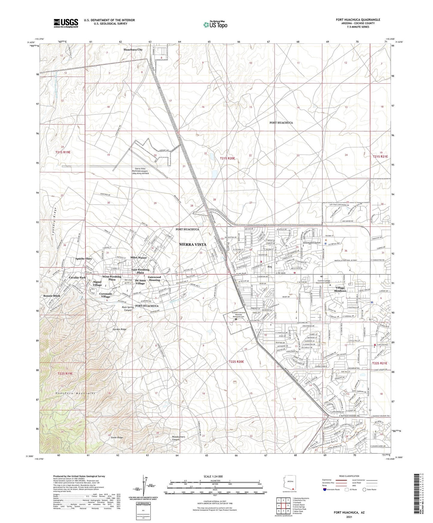
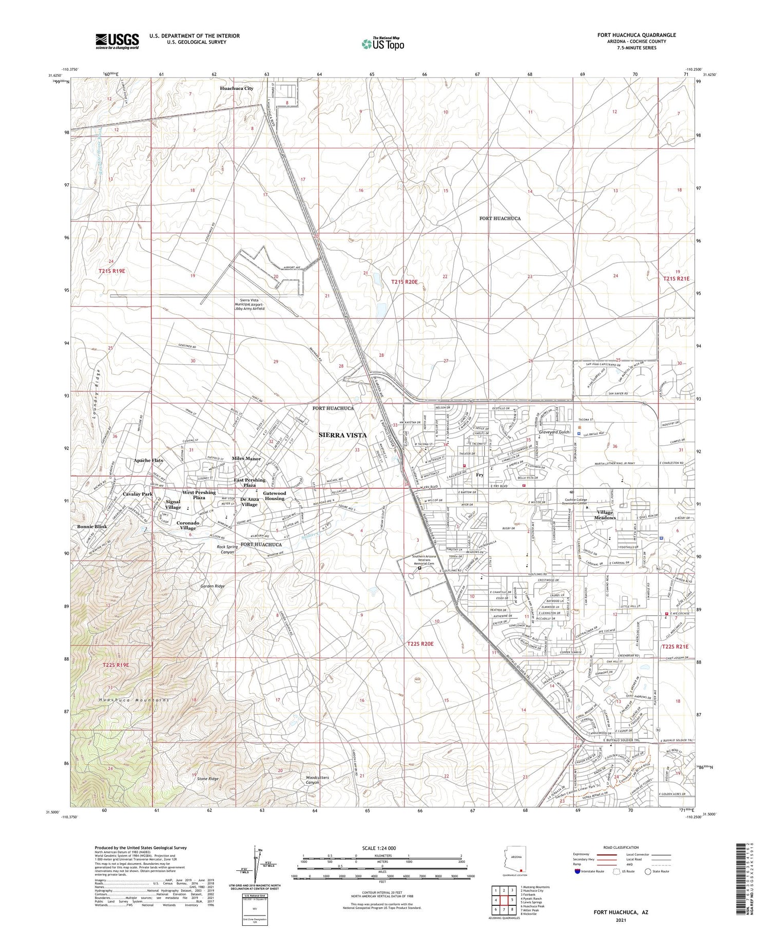
2021 topographic map quadrangle Fort Huachuca in the state of Arizona. Scale: 1:24000. Based on the newly updated USGS 7.5' US Topo map series, this map is in the following counties: Cochise. The map contains contour data, water features, and other items you are used to seeing on USGS maps, but also has updated roads and other features. This is the next generation of topographic maps. Printed on high-quality waterproof paper with UV fade-resistant inks.
Quads adjacent to this one:
West: Pyeatt Ranch
Northwest: Mustang Mountains
North: Huachuca City
Northeast: Fairbank
East: Lewis Springs
Southeast: Nicksville
South: Miller Peak
Southwest: Huachuca Peak
This map covers the same area as the classic USGS quad with code o31110e3.
Contains the following named places: Apache Flats, Arizona State Highway Patrol District 9 - Sierra Vista, Barnes Field House, Bella Vista Elementary School, Bella Vista Neighborhood Park, Bethel Church, Bonnie Blink, Buena High School, Buena School, Busby Park, Calvary Chapel of Sierra Vista, Carmichael Elementary School, Cavalay Park, Center For Academic Success, Central Baptist Church, Chaffee Field Parade Ground, Christian House of Fellowship Church, City of Sierra Vista, Cochise County Sheriff's Office Sierra Vista District, Cochise Plaza Shopping Center, Colonel Johnston Elementary School, Colonel Smith Middle School, Community of Christ, Coronado Village, Coronado Village Shopping Center, De Anza Village, East Gate, East Pershing Plaza, Ethel H Berger Center, First Assembly of God, First Baptist Christian Academy, First Christian Church, Fort Huachuca, Fort Huachuca Military Reservation, Fry, Fry Fire District Station 1, Garden Ridge, Garden Terrace Assisted Living Center, Gatewood Housing, General Myer Elementary School, Greater Antioch Missionary Baptist Church, Greely Hall, Hacienda Rehabilitation and Care Center, Hayes Hall, Henry F Hauser Museum, Huachuca Mountain Elementary School, Immanuel Lutheran Church, Joyce Clark Middle School, Kartchner Substation, KFFN-FM (Sierra Vista), Kingdom Hall of Jehovahs Witnesses, KTAN-AM (Sierra Vista), KTAZ-FM (Sierra Vista), Laundry Ridge, Life Care Center of Sierra Vista, Life in Christ Church, Los Arcos Mobile Home Park, Miles Manor, New Hope House of Prayer, Oscar Yrun Community Center, PPEP Tec High School - Colin L Powell Learning Center, Prestige Assisted Living at Sierra Vista, Pueblo Del Sol Country Club, Raymond W Bliss Army Health Center, Raymond W Bliss Army Hospital, Riley Barracks, Rock Spring Canyon, Rothery Educational Center, Saint Andrew the Apostle Roman Catholic Church, Saint Paul Missionary Baptist Church, Saint Stephen's Episcopal Church, Shiloh Christian Church, Shiloh Christian School, Sierra Evangelical Lutheran Church, Sierra Grande Mobile Home Park, Sierra Vista, Sierra Vista City Hall, Sierra Vista City Park, Sierra Vista Fire and Medical Services Station 1, Sierra Vista Fire Department Station 2, Sierra Vista First Baptist Church, Sierra Vista First Church of God in Christ, Sierra Vista First Church of the Nazarene, Sierra Vista Municipal Airport-Libby Army Airfield, Sierra Vista Police Department, Sierra Vista Post Office, Sierra Vista Public Library, Sierra Vista Regional Health Center, Sierra Vista Regional Health Center Heliport, Sierra Vista Seventh Day Adventist Church, Sierra Vista United Methodist Church, Signal Village, Soldier Creek, Southern Arizona Veterans Memorial Cemetery, Stone Ridge, The Mall at Sierra Vista, Thunder Mountain Community Church, Tompkins Memorial Park, Town and Country Elementary School, Trinity Orthodox Lutheran Church, Villa Vista Alzheimers Care, Village Meadows, Village Meadows Baptist Church, Village Meadows Church of Christ, Village Meadows Elementary School, West Pershing Plaza, Woodcutters Canyon