MyTopo
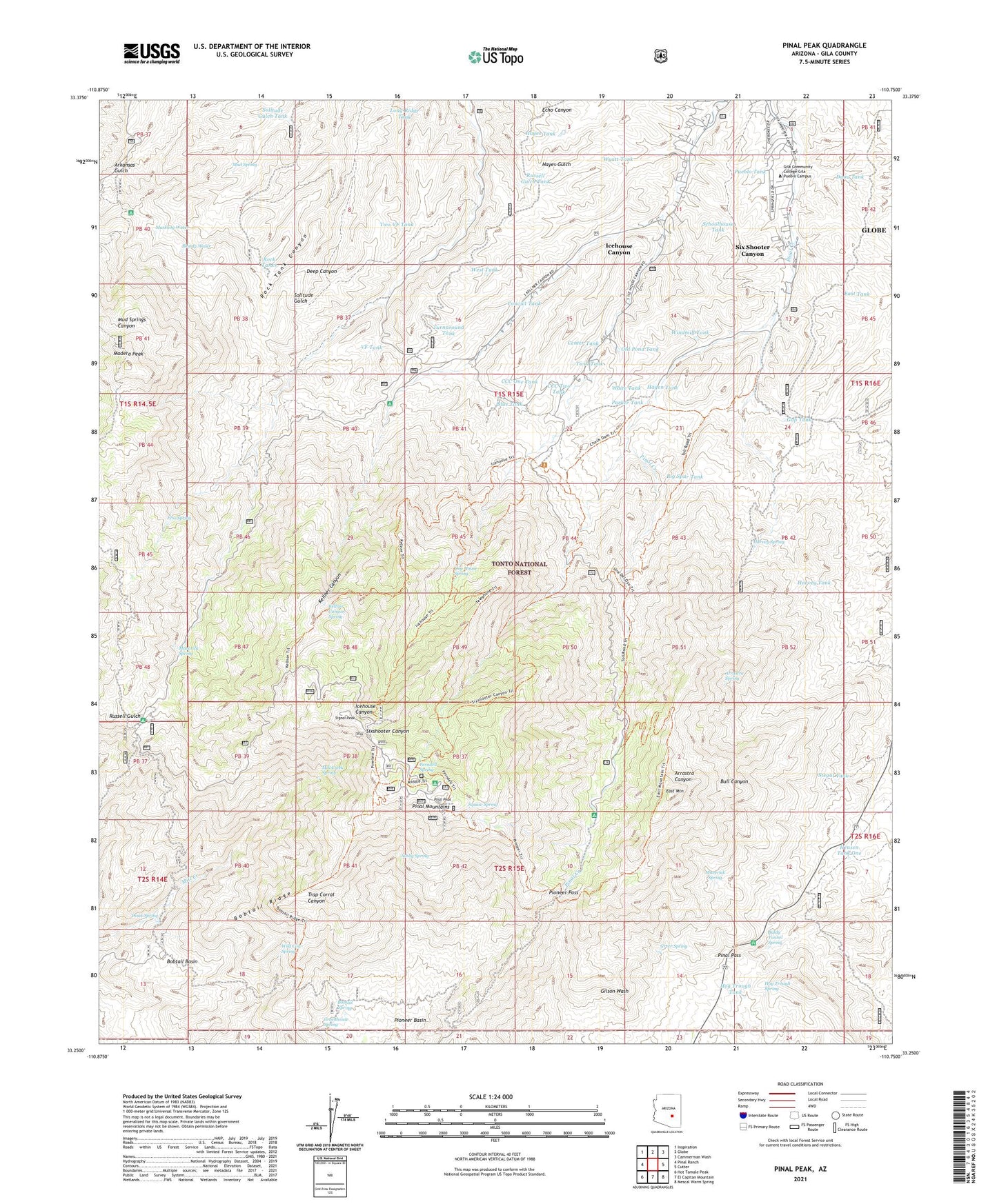
Pinal Peak Arizona US Topo Map
Couldn't load pickup availability
Also explore the Pinal Peak Forest Service Topo of this same quad for updated USFS data
2023 topographic map quadrangle Pinal Peak in the state of Arizona. Scale: 1:24000. Based on the newly updated USGS 7.5' US Topo map series, this map is in the following counties: Gila. The map contains contour data, water features, and other items you are used to seeing on USGS maps, but also has updated roads and other features. This is the next generation of topographic maps. Printed on high-quality waterproof paper with UV fade-resistant inks.
Quads adjacent to this one:
West: Pinal Ranch
Northwest: Inspiration
North: Globe
Northeast: Cammerman Wash
East: Cutter
Southeast: Mescal Warm Spring
South: El Capitan Mountain
Southwest: Hot Tamale Peak
This map covers the same area as the classic USGS quad with code o33110c7.
Contains the following named places: Arrastra Spring, Ashby Spring, August Hills Mobile Home Park, Azurite Mine, Baldy Tunnel Spring, Big Spur Tank, Blondy Water, Blue Tank, Bobtail Basin, Bobtail Ridge, Bobtail Spring, Camp Carlock Water Tank, Captain Pass Family Picnic Area, CCC One Tank, CCC Two Tank, Cedar Creek Tank, Center Tank, Convict Tank, Daou Tank, Doak Spring, Dog House Spring, East Mountain, East Tank, Ferndell Spring, Forest Ranch Windmill, Fork Tank, Frio Spring, Gap Tank, Gap Windmill, Gila Community College Gila Pueblo Campus, Greenhouse Spring, Greer Spring, Hagen Tank, Harvey Mill Well, Harvey Mine, Harvey Spring, Harvey Tank, Hayes Tank, Hensen Tank One, Hog Trough Spring, Hog Trough Tank, Ice House CCC Campground, Icehouse Canyon Census Designated Place, Kellner Campground, Kellner Canyon, Kellner Canyon Spring, KGRX-FM (Globe), KIKO-FM (Globe), Little Summit, Long Ridge Tank, Madera Peak, Maverick Spring, Mill Creek Spring, Mud Spring, Muskhog Water, O'Banion Mobile Home Park, Old Pond Tank, Parker Tank, Pinal Campground, Pinal Mountains, Pinal Pass, Pinal Peak, Pioneer Basin, Pioneer Pass, Pioneer Pass Campground, Pueblo Tank, Rock Tank Canyon, Rock Tanks, Russell Gulch Tank, Schoolhouse Tank, Signal Peak, Signal Peak Lookout Tower, Six Shooter Canyon Census Designated Place, Sixty Six Ranch, Solitude Gulch Tank, Southwest Archeological Center, Squaw Spring, Stegal Tank, Sulphide Del Ray Campground, Turnaround Tank, Twin Tank, Two VF Tank, Upper Pinal Campground, VF Tank, West Tank, Westlake Mine, White Tank, Wild Cow Spring, Windmill Tank, Wyatt Tank