MyTopo
Globe Arizona US Topo Map
Couldn't load pickup availability
Also explore the Globe Forest Service Topo of this same quad for updated USFS data
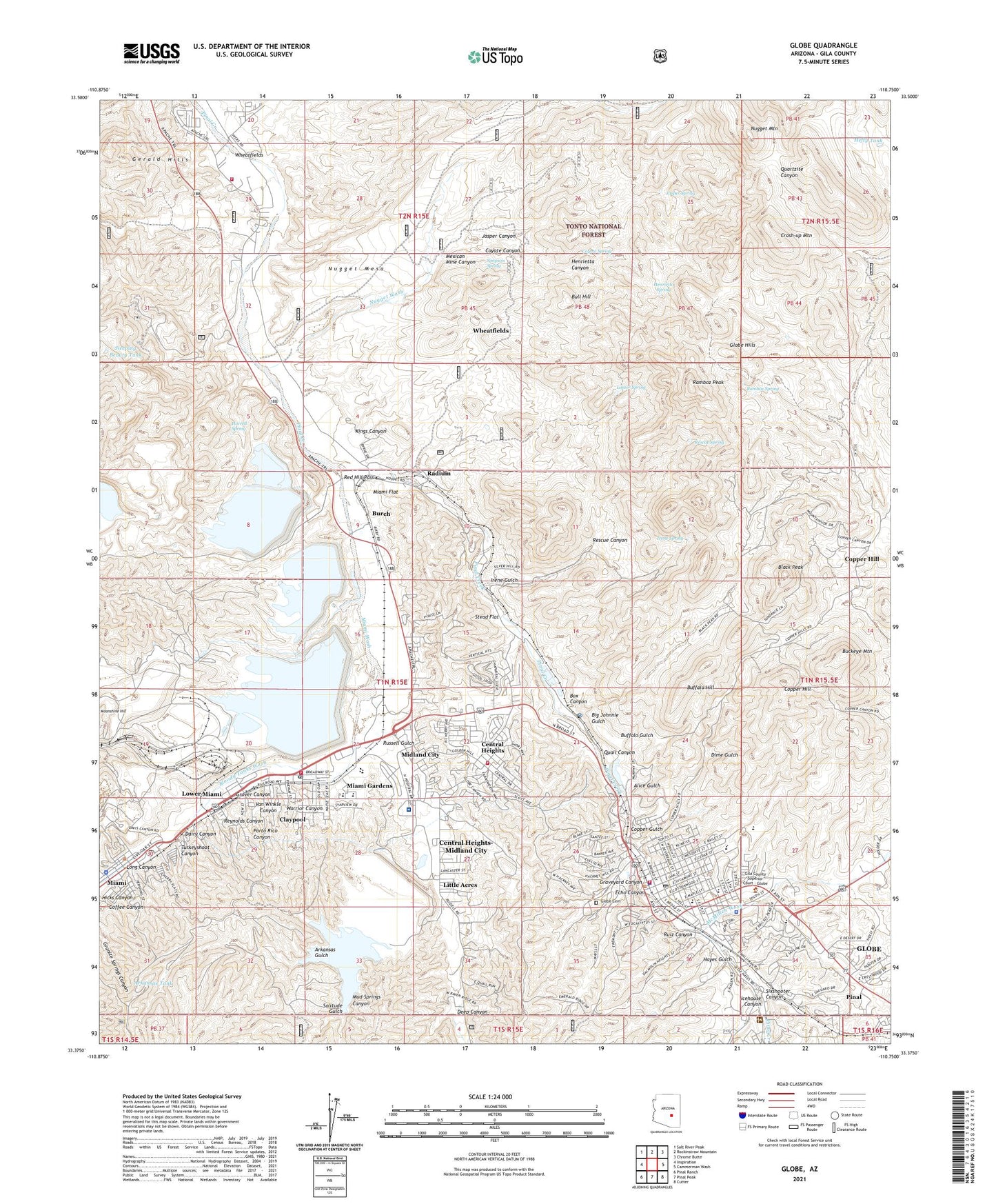
2021 topographic map quadrangle Globe in the state of Arizona. Scale: 1:24000. Based on the newly updated USGS 7.5' US Topo map series, this map is in the following counties: Gila. The map contains contour data, water features, and other items you are used to seeing on USGS maps, but also has updated roads and other features. This is the next generation of topographic maps. Printed on high-quality waterproof paper with UV fade-resistant inks.
Quads adjacent to this one:
West: Inspiration
Northwest: Salt River Peak
North: Rockinstraw Mountain
Northeast: Chrome Butte
East: Cammerman Wash
Southeast: Cutter
South: Pinal Peak
Southwest: Pinal Ranch
This map covers the same area as the classic USGS quad with code o33110d7.
Contains the following named places: Alhambra Mobile Home Park, Alice Gulch, Arizona Highway Department - Claypool, Arkansas Gulch, Arkansas Tank, Ash Spring Wash, Big Johnnie Gulch, Big Johnnie Shaft, Bixby Ranch, Black Peak, Bloody Tanks Wash, Box Canyon, Buckeye Mountain, Buckeye Shaft, Buffalo Gulch, Buffalo Hill, Bull Hill, Bullion Plaza School, Burch, Central Heights, Central Heights School, Central Heights-Midland City Census Designated Place, Church of Christ, City of Globe, City of Pinal Creek Wastewater Treatment Plant, Claypool, Claypool Census Designated Place, Claypool Clinic, Claypool Post Office, Claypool United Methodist Church, Cobre Valley Center for the Arts, Cobre Valley Regional Medical Center, Coffee Canyon, Copper Cities Tailings Dam Number Eight, Copper Cities Tailings Dam Number Two, Copper City, Copper City Mine Open Pit, Copper Gulch, Copper Hill, Copper Hill Census Designated Place, Copper Hill Tank, Copper Mountain Inn Skilled Nursing Hospital, Copper Rim Elementary School, Corre Valley Country Club, Coyote Canyon, Coyote Spring, Crash-up Mountain, Dairy Canyon, Deep Canyon, Destiny School, Dimario Place, Dime Gulch, Divine Grace Presbyterian Church, Doctor Charles A Bejarano Elementary School, Doughboy Shaft, East Globe Elementary School, Echo Canyon, Family Fellowship Church, First Baptist Church of Miami, First Christian Church, First Presbyterian Church, First Southern Baptist Church, Gem Shaft, George Washington School, Gerald Hills Tank, Gerald Wash, Gerald Well, Gila County Courthouse, Gila County Hospital, Gila County Sheriff's Office Globe, Globe, Globe Cemetery, Globe Church of the Nazarene, Globe City Hall, Globe Community Center, Globe Fire Department, Globe High School, Globe Hills, Globe Mobile Home Park, Globe Police Department, Globe Post Office, Globe Public Library, Globe Railroad Station, Globe Ranger District, Graveyard Canyon, Grey Shaft, Grover Canyon, Hayes Gulch, Hefty Tank, Henrietta Canyon, Henrietta Spring, Hicks Canyon, Holy Angels Catholic Community, Holy Angels School, Hoopes Quarry, Hoosier Shaft, Horrel Well, Horrell Spring, Horse Tank Number Two, Icehouse Canyon, Inspiration Addition School, Inspiration Concentrator, Inspiration Tailings Dam Number Four, Inspiration Tailings Dam Number One, Inspiration Tailings Dam Number Three, Inspiration Tailings Dam Number Two, International Smelter, Ireland Shaft, Irene Gulch, Irene Spring, Irene Tunnels, Iron Cap Shaft, Jasper Canyon, Jasper Spring, Jasper Well, Jones Ranch, KIKO-AM (Miami), KIKO-FM (Claypool), Kings Canyon, Kings Well, KJAA-AM (Globe), KPPR-AM (Globe), KQSS-FM (Miami), KRXS-FM (Globe), KSML-AM (Globe), Las Lomas Elementary School, Lea Tunnels, Lee Kornegay Junior High School, Liberty High School, Limestone Quarry, Liquor Spring, Little Acres, Little Acres Mobile Home Park, Long Canyon, Louis D'Or Shaft, Lower Miami, Mallory Shaft, Maranatha Baptist Church, McCormick Wash, McMillen Wash, Mexican Mine Canyon, Miami, Miami Church of Christ, Miami Concentrator, Miami Flat, Miami Gardens, Miami Junior Senior High School, Miami Police Department, Miami Post Office, Miami Railroad Station, Miami Tailings Dam Number Two, Miami Tailings Pond, Miami Wash, Middle School, Midland City, Midland School, Morans Well, Mud Springs Canyon, Nugget Mountain, Nugget Wash, Oak Street School, Old Dominion Library, Old Dominion Shaft, Our Lady of the Blessed Sacrament Church, Pinal, Pinal Census Designated Place, Pinal Ranger Station, Porto Rico Canyon, Quail Canyon, Quartsite Tank, Radium, Ramboz Peak, Ramboz Spring, Ramboz Well, Red Hill Pass, Rescue Canyon, Rescue Spring, Reynolds Canyon, Ruiz Canyon, Russell Gulch, Saint Johns Episcopal Church, Saint Pauls Lutheran Church, Saint Paul's United Methodist Church, Saint Peter's Lutheran Church, Simpson Cabins, Simpson Spring, Sixshooter Canyon, Sleeping Beauty Tank, Solitude Gulch, Solitude Tailings Dam, Solitude Tailings Pond, Stead Flat, Superior and Boston Sraft, Superior Mine, Tailings Pond Number One, Tailings Pond Number Three, Tailings Pond Number Two, The Church of Jesus Christ of Latter Day Saints, Tin Horn Tailing Dam, Tinhorn Wash, Town of Miami, Tri - City Fire Department Station 11, Tri - City Fire Department Station 21, Tri - City Fire Department Station 22, Trinity Baptist Church, Turkeyshoot Canyon, Van Dyke Shaft, Van Winkle Canyon, Vanadium Shaft, Warrior Canyon, Wheatfields, Wheatfields Census Designated Place, Williams Shaft, Word of Life Assembly of God