MyTopo
Safford Arizona US Topo Map
Couldn't load pickup availability
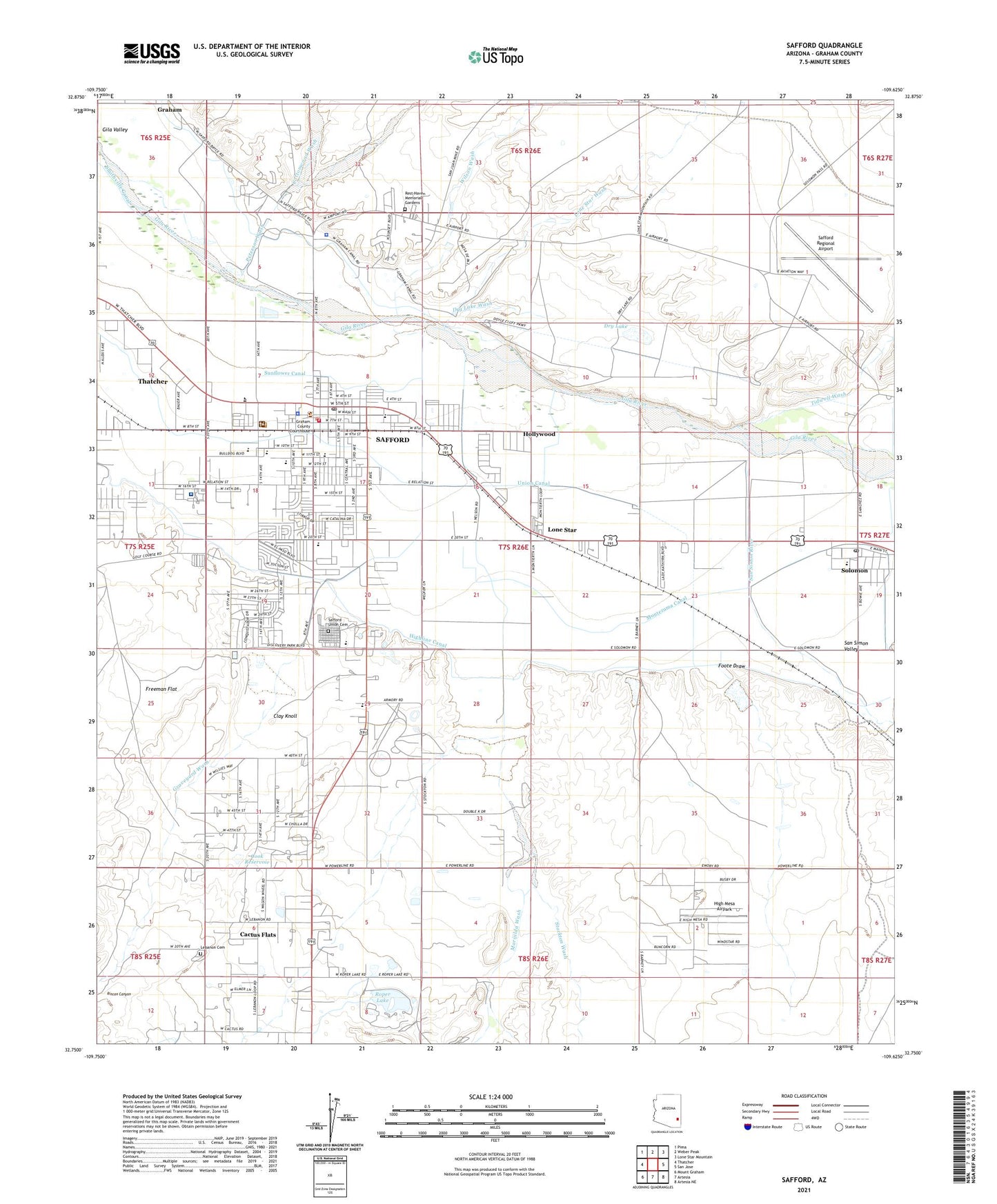
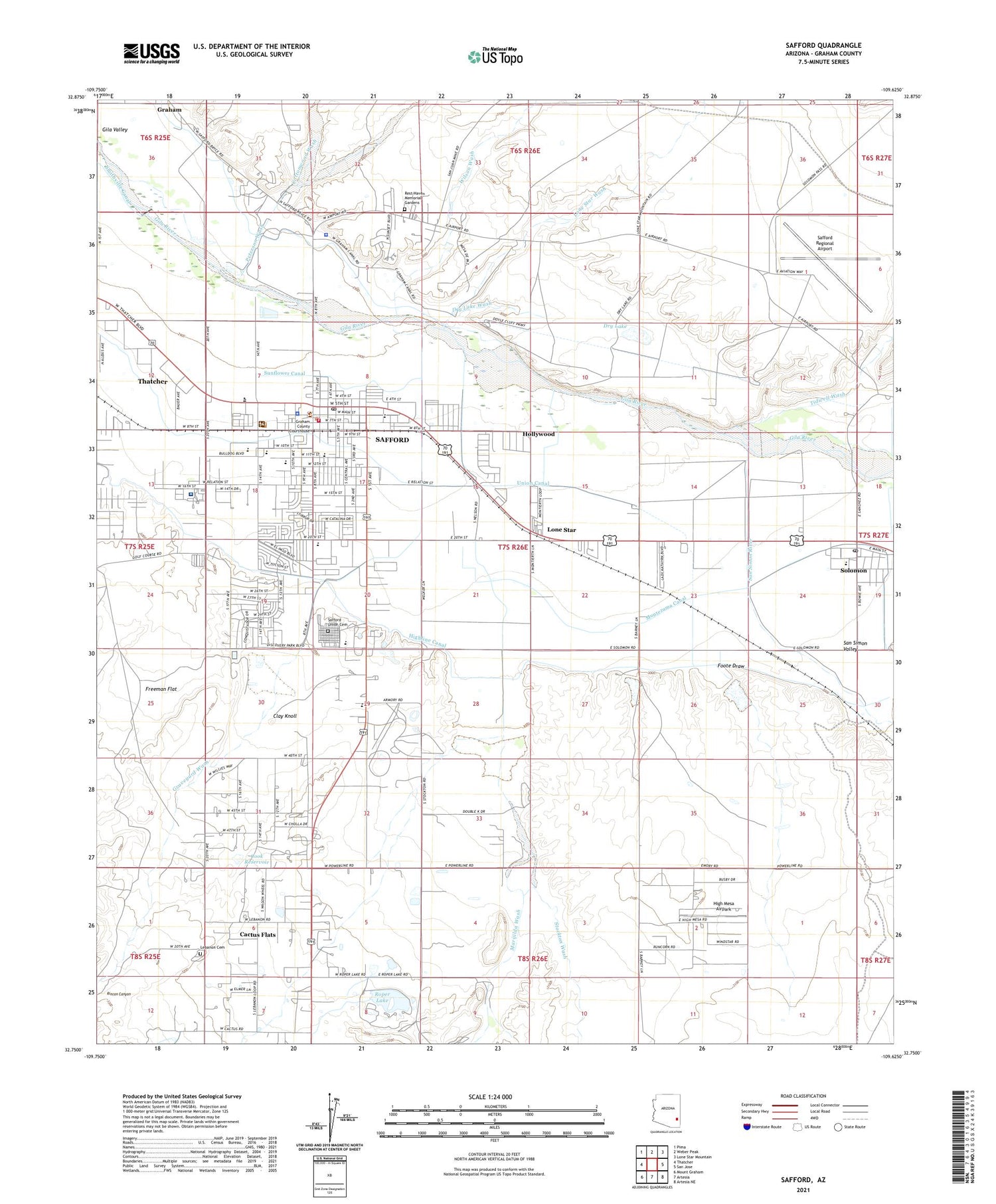
2021 topographic map quadrangle Safford in the state of Arizona. Scale: 1:24000. Based on the newly updated USGS 7.5' US Topo map series, this map is in the following counties: Graham. The map contains contour data, water features, and other items you are used to seeing on USGS maps, but also has updated roads and other features. This is the next generation of topographic maps. Printed on high-quality waterproof paper with UV fade-resistant inks.
Quads adjacent to this one:
West: Thatcher
Northwest: Pima
North: Weber Peak
Northeast: Lone Star Mountain
East: San Jose
Southeast: Artesia NE
South: Artesia
Southwest: Mount Graham
This map covers the same area as the classic USGS quad with code o32109g6.
Contains the following named places: All Saints Episcopal Church, Arizona Highway Department and Highway Patrol, Arizona Highway Department Maintenance Yard, Cactus Dam, Cactus Flat, Cactus Flats Census Designated Place, City of Safford, City of Safford Water Reclamation Plant, Clay Knoll, Cook Reservoir, Cottonwood Wash, Dorothy Stinson Elementary School, Dry Lake, Dry Lake Wash, Faith Lutheran Church, First Baptist Church of Safford, First Christian Church, Foote Draw, Foote Wash Dam, Freeman Flat, Freeman Wash, Freeman Wash Retarding Dam, Gila Preparatory Academy, Grace Tabernacle Church, Graham County Courthouse, Graham County Fair Ground, Graham County Health Department, Graham County Highway Maintenance Yard, Graham County Sheriff's Office, Graveyard Wash, Graveyard Wash Retarding Dam, Harvest Tabernacle, High Mesa Airpark, Highline Canal, Hollywood, Kingdom Hall of Jehovahs Witnesses, Lafe Nelson School, Lebanon Cemetery, Lexington Pines Mobile Home Park, Lone Star, Lone Star Wash, Los Milagros Academy, Marijilda Wash, Montezuma Canal, Mount Graham High School, Mount Graham Regional Medical Center, New Beginnings Church, New Testament Baptist Church, No Name Wash Dam, Our Lady of Guadalupe, Peterson Wash, Real Life Community Church, Rest Haven Memorial Gardens, Roper Dam, Roper Lake, Ruth Powell Elementary School, Safford, Safford Christian Academy, Safford Church of Christ, Safford City - Graham County Library, Safford City Hall, Safford Fire Department, Safford High School, Safford Inn Hospital, Safford Middle School, Safford Police Station, Safford Post Office, Safford Railroad Station, Safford Ranch Mobile Home Park, Safford Regional Airport, Safford Seventh Day Adventist Church, Safford Seventh Day Adventist School, Safford Union Cemetery, Saint Andrew Baptist Church, Saint Rose of Lima Catholic Church, San Simon River, San Simon Valley, Santiago Silver Creek Mobile Home Park, Smith Detention Dam, Solomon, Solomon Census Designated Place, Solomon Elementary School, Solomon Post Office, Solomon Siding, Stockton Pass Dam, Stockton Wash, Stockton Wash Retarding Dam, Sunflower Canal, Sunrise Village Mobile Home Park, Sunset Hills Care and Rehabilitation, The Church of Jesus Christ of Latter Day Saints, Tidwell Wash, Tower Mobile Home Park, Triumphant Learning Center, Union Canal, University of Arizona Agricultural Experiment Station, Victory Fellowship Church, Wilson Wash