MyTopo
Barling Arkansas US Topo Map
Couldn't load pickup availability
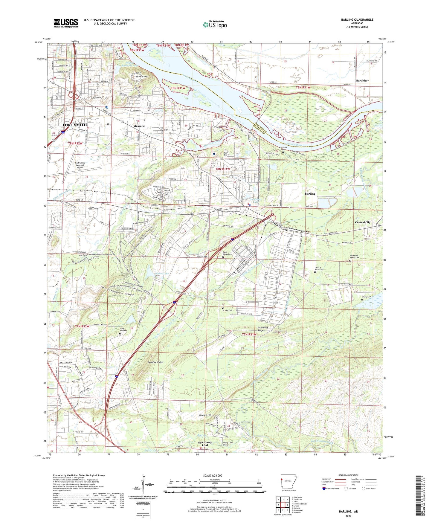
2024 topographic map quadrangle Barling in the state of Arkansas. Scale: 1:24000. Based on the newly updated USGS 7.5' US Topo map series, this map is in the following counties: Sebastian, Crawford. The map contains contour data, water features, and other items you are used to seeing on USGS maps, but also has updated roads and other features. This is the next generation of topographic maps. Printed on high-quality waterproof paper with UV fade-resistant inks.
Quads adjacent to this one:
West: South Fort Smith
Northwest: Fort Smith
North: Van Buren
Northeast: Alma
East: Lavaca
Southeast: Burnville
South: Greenwood
Southwest: Hackett
This map covers the same area as the classic USGS quad with code o35094c3.
Contains the following named places: 188th Fighter Wing Air National Guard Security Squadron, 72903, 72923, Advance Care Hospital Fort Smith, Arkansas Game and Fish Commission Law Enforcement Fort Smith Regional Office, Barling, Barling Cemetery, Barling City Hall, Barling Elementary School, Barling Police Department, Barling Post Office, Barling School, Barling Volunteer Fire Department, Bear Creek, Ben Geren Regional Park, Bethel Lutheran Church, Bonneville Elementary School, Bost School, Carol Ann Cross Park, Central City, Chaffin Junior High School, City of Barling, City of Fort Smith, City of Fort Smith Landfill, Cliff Terrace Assembly of God Church, Cooper Clinic, Crescent, Dam Site North Public Use Area, Dam Site South Public Use Area, Donahoe Ridge, East Side Baptist Church, Essex Place Shopping Center, Euper Lane Elementary School, Faith Freewill Baptist Church, Federal Bureau of Investigation, Flat Rock Creek, Fort Chaffee, Fort Chaffee Control Tower, Fort Chaffee Landing Strip, Fort Chaffee Police Department, Fort Smith Fire Department Station 6, Fort Smith Fire Department Station 7, Fort Smith Post Office, Fort Smith Racquet Club, Fort Smith Regional Airport, Grayson Creek, Haroldton, Howard Hill, Howard Hill Church, Howard Hill School, Jenny Lind, Jenny Lind Bridge, Jenny Lind Fire Department, John P Woods Elementary School, KOLX-FM (Barling), KVOG-AM (Greenwood), Laura A Nolan Cemetery, Laville Shopping Center, Little Massard Creek, Lock and Dam Number 13, Lutheran School, Massard, Massard Baptist Church, Massard Creek, Massard United Methodist Church, Mc Allister Cemetery, Mc Coy Cemetery, McMahan Lake, McMahan Lake Dam, Mercy Hospital Fort Smith, Negro Hill Church, New Jenny Lind, Pool 13, Post School, Prairie Creek, Provost Marshal Office Fort Chaffee, Rye Hill, Rye Hill Baptist Church, Saint Edward Mercy Medical Center Heliport, Saint Luke Lutheran Church, Saint Marys Cemetery, Saint Marys Church, Saint Marys School, Seventh Day Church of God, Spredding Ridge, Steep Hill Cemetery, Stonewall Village Shopping Center, The Oaks Shopping Center, Town East Shopping Center, Township of Mont Sandels, Township of Sulphur, Township of Upper, Tuberculosis Sanitorium, Valley Behavioral Health System, Vista Health Fort Smith, Waldron Place Medical Center, Waldron Square Shopping Center, West Arkansas Regional Park, White and Shelby Cemetery, Wildcat Mountain, Wildcat Mountain Lake, Wildcat Mountain Lake Dam, Willies Lake, Willies Lake Dam, Wisely Cemetery, Woods Elementary School