MyTopo
Camden Arkansas US Topo Map
Couldn't load pickup availability
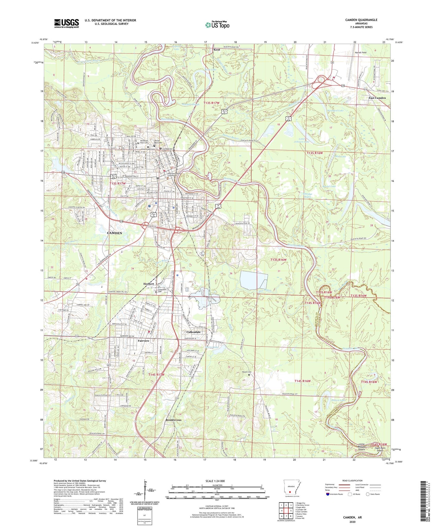
2024 topographic map quadrangle Camden in the state of Arkansas. Scale: 1:24000. Based on the newly updated USGS 7.5' US Topo map series, this map is in the following counties: Ouachita, Calhoun. The map contains contour data, water features, and other items you are used to seeing on USGS maps, but also has updated roads and other features. This is the next generation of topographic maps. Printed on high-quality waterproof paper with UV fade-resistant inks.
Quads adjacent to this one:
West: Camden SW
Northwest: Bragg City
North: Harmony Grove
Northeast: Eagle Mills
East: East Camden
Southeast: Snow Hill
South: Louann
Southwest: Buena Vista
This map covers the same area as the classic USGS quad with code o33092e7.
Contains the following named places: 13th Judicial District Drug Task Force, 71701, Arkansas Game and Fish Commission Law Enforcement South Central Regional Office, Berg Lake, Berg Lake Dam, Bethel African Methodist Episcopal Church, Blue Lake, Bradley Ferry, Calvary Assembly of God Church, Calvary Baptist Church, Camden, Camden City Hall, Camden Fairview High School, Camden Fairview Intermediate School, Camden Fairview Middle School, Camden Fire Department, Camden Fire Station 2, Camden Fire Station 3, Camden High School, Camden Middle School, Camden Plaza Shopping Center, Camden Police Department, Camden Police Department Substation, Camden Post Office, Cape Horn Shoals, Cardinal Shopping Center, Carnes Park, Carver Elementary School, Chaffie Creek, Church of Christ, Church of God in Christ, City of Camden, City School Park, Cleveland Avenue School, Coleman Stadium, Confederate Cemetery, Cullendale, Cullendale Assembly of God Church, Cullendale Baptist Church, Cullendale Cemetery, Cullendale Church of Christ, Cumberland Church, Ecore Fabre Bayou, Estridge Bayou, Fairview, Fairview Community Center, Fairview High School, Fairview Junior High School, Fairview Middle School, Fairview Park, Fairview Primary School, Fairview Stadium, Fairview United Methodist Church, First Assembly of God Church, First Baptist Church, First Christian Church, First Presbyterian Church, First United Methodist Church, Fort Lookout Community Center, Fort Southerland Park, Garden Oaks Shopping Center, Grace Baptist Church, Greater Saint Paul Baptist Church, Greenwood Cemetery, Harrell Field, Herbert, Hillside Baptist Church, Hook Lake, Immanuel Baptist Church, Ira Clark Park, Ivory Primary School, Jewish Rest Cemetery, KAMD-AM (Camden), KCAC-FM (Camden), KCXY-FM (Camden), KJWH-AM (Camden), KWEH-FM (Camden), Lincoln High School, Linebarier Chapel, Little Buffalo Shoals, Little Johnson Lake, McCollum-Chidester House Museum, Memorial Park Cemetery, Mill Creek, Mizzell Creek, Mount Hebron Missionary Baptist Church, Mustin Lake, Nelson School, New Calvary Church of God in Christ, Newman Slough, Ouachita County Courthouse, Ouachita County Hospital Heliport, Ouachita County Medical Center, Ouachita County Sheriff's Office, Ouachita County Volunteer Fire Department Fire District 1 Harrell Field Station 4, Ouachita Medical Center, Palmer Bayou, Pedron Lake, Powell Cemetery, Rendezvous, Round Lake, Saint Johns Episcopal Church, Saint Louis Catholic Church, Saint Mark United Methodist Church, Sandy Beach Park, Second Baptist Church, Senrac Lake, Senrac Lake Dam, Shiloh Baptist Church, Southwest Shopping Center, Temple Baptist Church, Temple Christian Methodist Episcopal Church, Timothy United Methodist Church, Township of Bradley, Township of Ecore Fabre, Township of Lafayette, Treadway Slough, Trinity Baptist Church, Two Bayou, Wadleigh Branch, Webb Lake, West Gate Shopping Center, White City Baptist Church, Whiteside Elementary School, Whiteside Junior High School, Woodard Lake