MyTopo
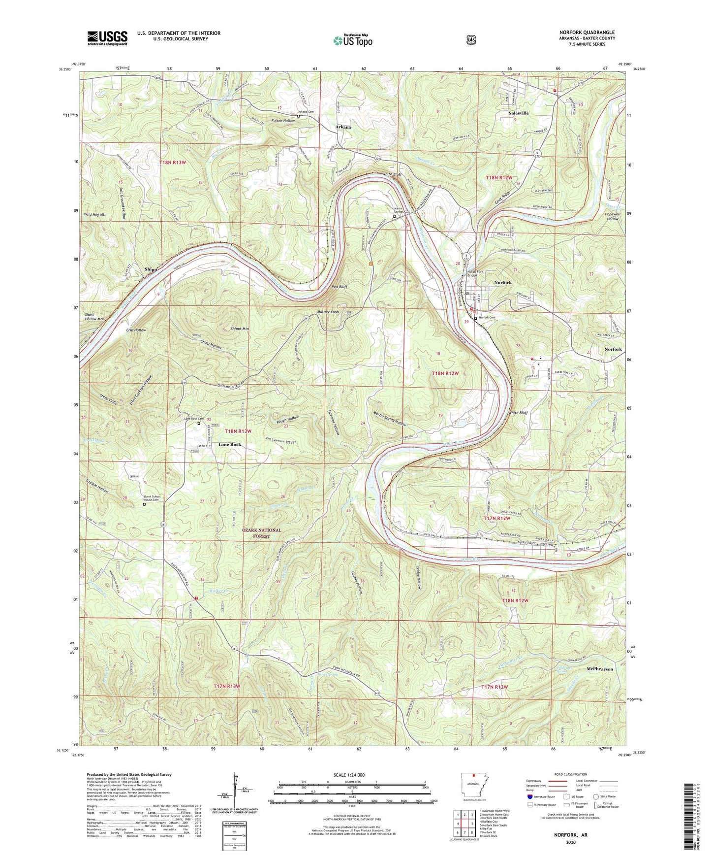
Norfork Arkansas US Topo Map
Couldn't load pickup availability
Also explore the Norfork Forest Service Topo of this same quad for updated USFS data
2024 topographic map quadrangle Norfork in the state of Arkansas. Scale: 1:24000. Based on the newly updated USGS 7.5' US Topo map series, this map is in the following counties: Baxter. The map contains contour data, water features, and other items you are used to seeing on USGS maps, but also has updated roads and other features. This is the next generation of topographic maps. Printed on high-quality waterproof paper with UV fade-resistant inks.
Quads adjacent to this one:
West: Buffalo City
Northwest: Mountain Home West
North: Mountain Home East
Northeast: Norfork Dam North
East: Norfork Dam South
Southeast: Calico Rock
South: Norfork SE
Southwest: Big Flat
This map covers the same area as the classic USGS quad with code o36092b3.
Contains the following named places: Arkana, Arkana Baptist Church, Arkana Cemetery, Arkana School, Arkana Station, Arrie Goforth Elementary School, Barren Creek, Big Creek, Bridge Hollow, Burnt School House Cemetery, Chastain, City of Norfork, City of Salesville, Coldwater Creek, Coldwater Spring, Community Church, Crib Hollow, Ellen Cockran Hollow, Farris Creek, Farris Spring, Flower Creek, Fulton Hollow, Gather Hollow, Glacia Church, Goat Ridge, Goose Creek, Havener Hollow, Herron, Herrons Creek, Hopewell Hollow, Lone Rock, Lone Rock Baptist Church, Lone Rock Cemetery, Lone Rock Volunteer Fire Department, Martin Spring Hollow, Martin Springs Cemetery, Martins Ferry, Matney Campground, Matney Knob, Matney Knob Lookout Tower, McPhearson, McPhearson School, Morton Creek, Mount Zion Church, Nelson Ferry, Norfork, Norfork Cemetery, Norfork High School, Norfork Landing, Norfork Post Office, Norfork Village, Norfork Volunteer Fire Station 1, Norfork Volunteer Fire Station 2, North Fork Bridge, North Fork River, Otter Creek, Red Bluff, Rough Hollow, Salesville, Salesville Volunteer Fire Department, Salt Ground Hollow, Shipp, Shipp Hollow, Shipps Ferry, Shipps Landing, Shipps Mountain, Short Hollow Mountain, Souths Ferry, Township of Buckhorn, Township of Lone Rock, Twin Creek, Vickory Creek, Walker Creek, White Bluff, Wild Hog Mountain, ZIP Code: 72658