MyTopo
Mountain Home West Arkansas US Topo Map
Couldn't load pickup availability
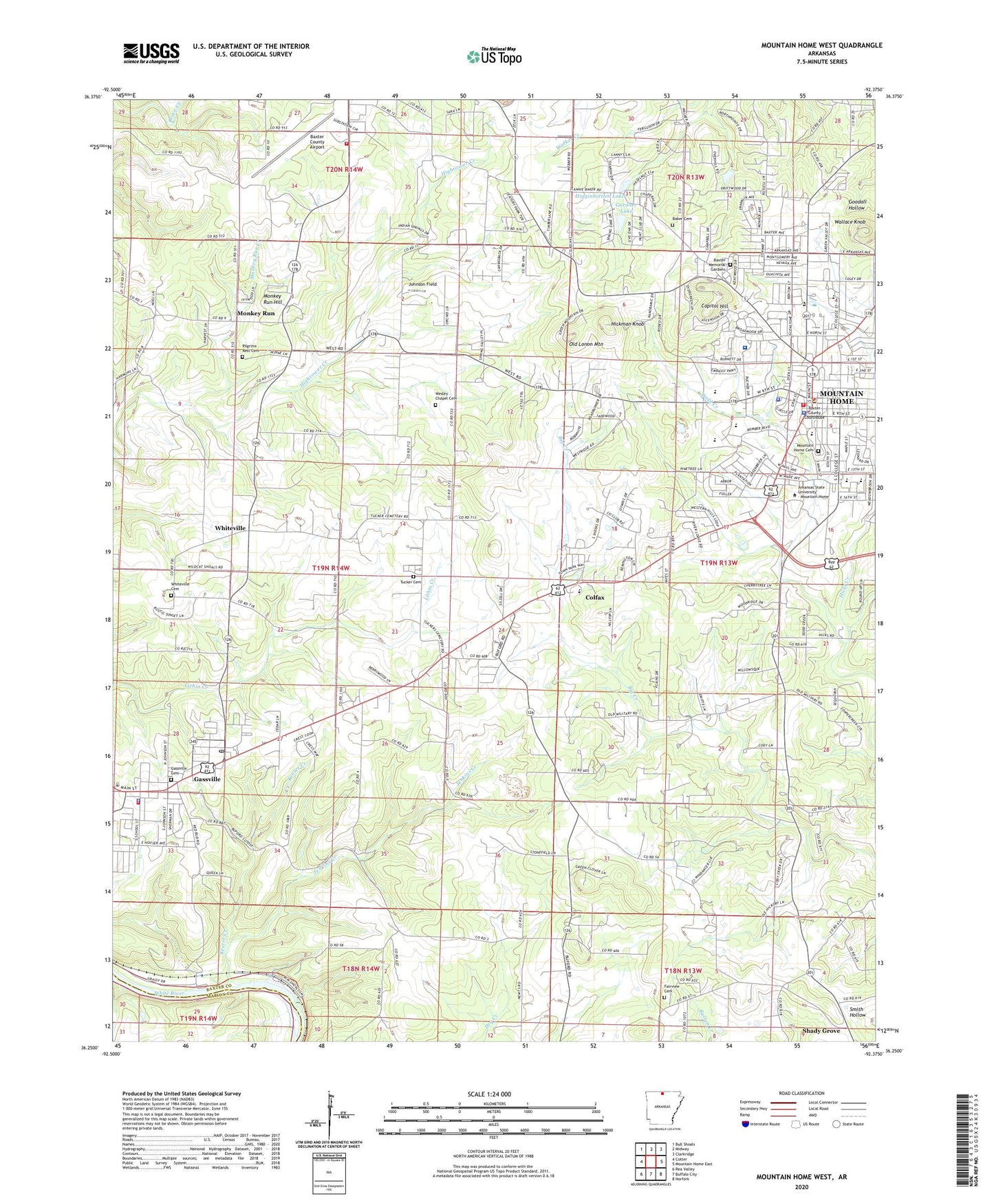
2024 topographic map quadrangle Mountain Home West in the state of Arkansas. Scale: 1:24000. Based on the newly updated USGS 7.5' US Topo map series, this map is in the following counties: Baxter, Marion. The map contains contour data, water features, and other items you are used to seeing on USGS maps, but also has updated roads and other features. This is the next generation of topographic maps. Printed on high-quality waterproof paper with UV fade-resistant inks.
Quads adjacent to this one:
West: Cotter
Northwest: Bull Shoals
North: Midway
Northeast: Clarkridge
East: Mountain Home East
Southeast: Norfork
South: Buffalo City
Southwest: Rea Valley
This map covers the same area as the classic USGS quad with code o36092c4.
Contains the following named places: Action Emergency Medical Services, Air - Evacuation Lifeteam 12 - Mountain Home, Baker Cemetery, Baxter County Airport, Baxter County Courthouse, Baxter County Regional Hospital Heliport, Baxter County Sheriff's Office, Baxter Memorial Gardens, Baxter Regional Medical Center, Bible Study Chapel, Capitol Hill, City of Gassville, City of Mountain Home, Colfax, College Plaza Shopping Center, Conville, Dodd Creek, East Side Baptist Church, Fairview Cemetery, Fairview United Methodist Church, First Baptist Church, First Christian Church, First Church of Christ Scientist, First United Methodist Church, Gardner Lake, Gardner Lake Dam, Gassville, Gassville Cemetery, Gassville Police Department, Gassville Post Office, Gassville Volunteer Fire Department, Hackler Intermediate School, Hickman Knob, Higginbottom Lake, Higginbottom Lake Dam, Hopewell Baptist Church, Independence, Jenkins Creek, Johnson Field, KCMH-FM (Mountain Home), Keeter Creek, KPFM-FM (Mountain Home), KTLO-AM (Mountain Home), KTLO-FM (Mountain Home), Lahar Field, Memorial Christian Church, Midway Fire Protection District, Monkey Run, Monkey Run Creek, Monkey Run Hill, Mountain Home, Mountain Home Cemetery, Mountain Home City Hall, Mountain Home Fire Department Station 1, Mountain Home High School, Mountain Home Junior High School, Mountain Home Kindergarten School, Mountain Home Methodist Church, Mountain Home Police Department, Nelson Wilks Herron Elementary School, Old Lonon Mountain, Ozark Acres Lake, Ozark Acres Lake Dam, Ozark Center Shopping Center, Pilgrims Rest Cemetery, Pilgrims Rest Missionary Baptist Church, Pinkston Middle School, Quality Ridge Church, Redeemer Lutheran Church, Reorganized Church of Jesus Christ of Latter Day Saints, Saint Andrews Episcopal Church, Saint Peters Catholic Church, Shady Grove, Shady Grove School, Spring Lake Estates, Starlite Drive-In, Township of Independence, Township of Whiteville, Tucker Cemetery, Wallace Knob, Wesley Chapel Cemetery, Wesley Chapel Methodist Church, Wesley Chapel School, West Side Missionary Baptist Church, Whiteville, Whiteville Baptist Church, Whiteville Cemetery, Whiteville School, ZIP Code: 72653