MyTopo
North Little Rock Arkansas US Topo Map
Couldn't load pickup availability
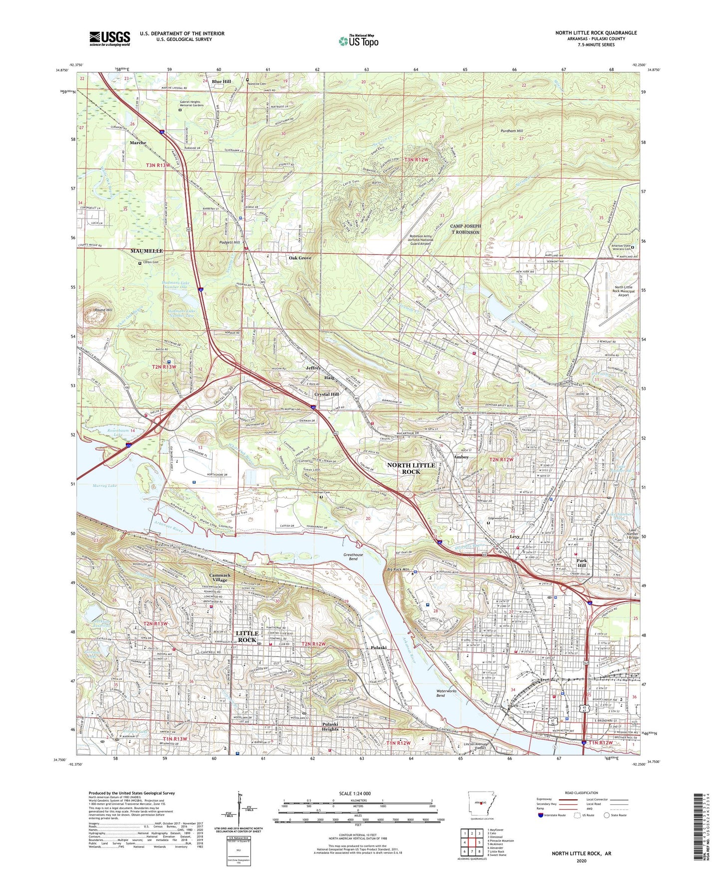
2024 topographic map quadrangle North Little Rock in the state of Arkansas. Scale: 1:24000. Based on the newly updated USGS 7.5' US Topo map series, this map is in the following counties: Pulaski. The map contains contour data, water features, and other items you are used to seeing on USGS maps, but also has updated roads and other features. This is the next generation of topographic maps. Printed on high-quality waterproof paper with UV fade-resistant inks.
Quads adjacent to this one:
West: Pinnacle Mountain
Northwest: Mayflower
North: Cato
Northeast: Olmstead
East: McAlmont
Southeast: Sweet Home
South: Little Rock
Southwest: Alexander
This map covers the same area as the classic USGS quad with code o34092g3.
Contains the following named places: A W Young Library, Alliance Bible Church, Allsopp Park, Amboy, Amboy Baptist Church, Amboy Elementary School, Amboy United Methodist Church, Argenta Elementary School, ARK. SCHOOL FOR THE BLIND ELEM, Arkansas School for Blind, Arkansas School for Deaf, Arkansas School for the Blind and Visually Impaired, Arkansas School for the Deaf Elementary School, Arkansas School for the Deaf High School, Arkansas State Veterans Cemetery, Arkansas Surgical Hospital, Arrowhead Manor, Baring Cross Baptist Church, Baring Cross School, Belleview School, Berean Baptist Church, Bethel African Methodist Episcopal Church, Bibleway Church of God in Christ, Big Rock Mountain, Blue Hill, Boone Park Elementary School, Brady Elementary School, Brady Post Office, Briarwood Christian School, Bright Star Church, Bullock Chapel, Burns Park, Burns Park Public Use Area, Calvary Assembly of God Church, Calvary Temple Church, Cammack Village, Cammack Village Police Department, Cammack Village Volunteer Fire Department, Camp Pike, Camp Robinson Dam Number Two, Camp Robinson Lake Dam Number One, Camp Robinson Lake Number One, Camp Robinson Lake Number Two, Camp Robinson Park, Camp Robinson Police Department, Camp Robinson Shopping Center, Camp Robinson Volunteer Fire Department, Cantrell Heights Shopping Center, Capital City Lighthouse Charter School, Catholic High School, Central Arkansas Christian School, Central Arkansas Veterans Healthcare System Eugene J Towbin Healthcare Center, Central Junior High School, Central Sixth Grade School, Church of Christ, Church of God of Prophecy, City of Cammack Village, Cooks Landing Park, Corbin Cemetery, Crystal Hill, Crystal Hill Church, Crystal Hill Elementary School, Crystal Valley Church, Edgewood Cemetery, Fair Park Elementary School, Foreman Lake, Foreman Lake Dam, Forest Heights Junior High School, Forest Heights STEM Academy, Forest Park Elementary School, Forest Park Post Office, Fort Logan H Roots, Foxboro, Gabriel Heights Memorial Gardens, Grassy Flat Creek, Greater Little Rock Stockyards, Greathouse Bend, Haig, Hall High School, Heilman Cemetery, Hillcrest Historic District, Hillcrest Post Office, Hillside School, Hudmans Lake Dam Number One, Hudmans Lake Dam Number Two, Hudmans Lake Number One, Hudmans Lake Number Two, Idlewild Shopping Center, Jackson Reservoir, Jackson Reservoir Dam, Jefferson Elementary School, Jeffrey, Jimerson Creek, KWNN-AM (Little Rock), La Harpe View Park, Lake Number 1 Bridge, Lake Number Six, Lake Number Three, Lakehill Shopping Center, Lakewood Lake Number Six Dam, Lakewood Lake Number Three Dam, Levy, Levy Elementary School, Levy Shopping Center, Lincoln Avenue Viaduct, Little Rock College, Little Rock Country Club, Little Rock Fire Department Station 10, Little Rock Fire Department Station 12, Little Rock Fire Department Station 7, Little Rock Junior Academy, Little Rock Water Filtration Plant, Main Office North Little Rock Post Office, Marche, McRae School, Melanie Park, Memorial Hospital, Meriwether Park, Metropolitan Emergency Medical Service Little Rock Station 7, Metropolitan Emergency Medical Service Little Rock Station 8, Metropolitan Emergency Medical Service Little Rock Station 9, Mineral, Montessori School, Mount Saint Mary Academy, Murray Dam Site Public Use Area, Murray Lock and Dam, Murray Park, New Life Church, Newton Creek, Newton Valley School, North Heights Elementary School, North Heights Recreation Center, North Little Rock, North Little Rock Boys Club, North Little Rock City Hall, North Little Rock Fire Department Station 1, North Little Rock Fire Department Station 3, North Little Rock Fire Department Station 4, North Little Rock Fire Department Station 5, North Little Rock Fire Department Station 6, North Little Rock Fire Department Station 8, North Little Rock High School, North Little Rock Municipal Airport, North Little Rock Police Department, North Little Rock Police Department Downtown Substation, North Little Rock Police Department Eastgate Office, North Little Rock Police Department Levy Substation, North Little Rock Police Department Parkhill Office, North Little Rock Police Department South Substation, North Oaks, North Park Mall Shopping Center, Northgate Plaza Shopping Center, Oak Grove, Oak Grove Elementary School, Oak Grove Fire Department - District 25 Station 2, Oak Grove High School, Oak Grove School, Ole Main High School, Our Lady of Holy Souls School, Overlook Park, Padgett Hill, Palestine Cemetery, Park Hill, Park Hill Elementary School, Park Hill Shopping Center, Park Plaza Mall Shopping Center, Parkhill Post Office, Pike Plaza Shopping Center, Pike View Elementary School, Pine Elementary School, Pine View School, Poplar Street Middle School, Pugh Park, Pulaski, Pulaski County, Pulaski County Sheriff Department Northside Booking, Pulaski County Sheriff Northwest Office, Pulaski Heights, Pulaski Heights Elementary School, Pulaski Heights Junior High School, Pulaski Heights Middle School, Pulaski Heights Shopping Center, Pulaski Technical College Campus Police Station, Pulaski Vocational-Technical School, Purdham Hill, Razorback Square Shopping Center, Rebsamen Park, Reservoir Park, Ridge Road Junior High School, Ridgeroad Middle Charter School, Riverdale Business Park, Riverfront Park, Riverside School, Riverview Medical Center, Riverview Park, Robinson Army Airfield/National Guard Airport, Rosenbaum Lake, Round Hill, Saint Anne Shrine, Saint Johns Seminary, Saint Josephs Orphanage, Saint Mary School, Saint Patricks School, Saint Vincent Infirmary Heliport, Saint Vincent Infirmary Medical Center, Select Specialty Hospital Little Rock, Seventh Street Elementary School, Shaw School, Sheraton Park, Sherman Park, Shilcotts Bayou, Shorter College, Squatters Island, Tanglewood, Tanglewood Shopping Center, The Bridgeway Hospital, Union Pacific Railroad Police, University of Arkansas Cammack Campus, Vali Hi Shopping Center, Vestal Park, Warren Hill Church, Waterworks Bend, Westgate Shopping Center, White Oak Bayou, William F Laman Public Library, Williams Traditional Magnet School, Wingate Lake, Wingate Lake Dam, Winifree Creek, ZIP Codes: 72114, 72118, 72119, 72205, 72207, 72227