
MyTopo
Sweet Home Arkansas US Topo Map
Couldn't load pickup availability
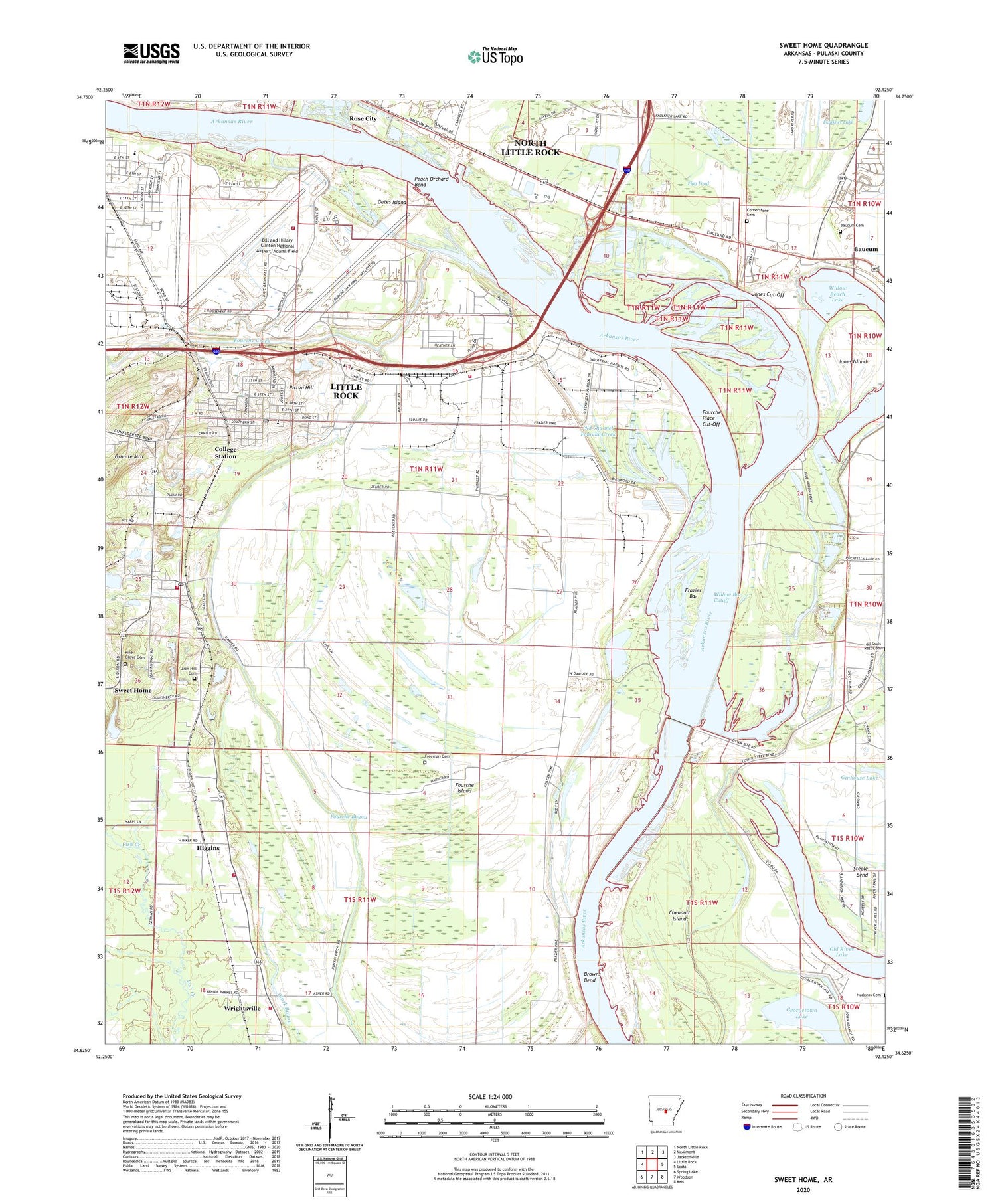
2024 topographic map quadrangle Sweet Home in the state of Arkansas. Scale: 1:24000. Based on the newly updated USGS 7.5' US Topo map series, this map is in the following counties: Pulaski. The map contains contour data, water features, and other items you are used to seeing on USGS maps, but also has updated roads and other features. This is the next generation of topographic maps. Printed on high-quality waterproof paper with UV fade-resistant inks.
Quads adjacent to this one:
West: Little Rock
Northwest: North Little Rock
North: McAlmont
Northeast: Jacksonville
East: Scott
Southeast: Keo
South: Woodson
Southwest: Spring Lake
This map covers the same area as the classic USGS quad with code o34092f2.
Contains the following named places: Alternative Learning Center, Antioch Church, Badgett Elementary School, Baucum, Baucum Cemetery, Beard School, Bethel Church, Bill and Hillary Clinton National Airport/Adams Field, Brown-Ratcliffe Mine, Browns Bend, Burks-Nelson Mine, Carver Magnet Elementary School, Charity, Cheetam Park, Chenault Island, College Station, College Station Census Designated Place, College Station Elementary School, College Station Post Office, Confederate Soldiers Home, Conner Chapel African Methodist Episcopal Church, Cornerstone Cemetery, David D Terry Lake, David D Terry Lock and Dam, David D Terry Park, Dixie Lease Mine, Dixie Number 1 Mine, Dixie Number 2 Mine, Dorough Mine, East End Park, England Open Pit Mine, First Baptist Church, Flag Pond, Fourche, Fourche Bayou, Fourche Creek, Fourche Dam, Fourche Island, Fourche Place Cut-Off, Frazier Bar, Frazier School, Freeman Cemetery, Gates Island, Ginhouse Lake, Gospel Temple Baptist Church, Greater New Hebron Baptist Church, Harley Mine, Harris Church, Hatter School, Higgins, Higgins Church, Highway 365 Volunteer Fire Department, Hoekstra Mine, Hoekstra-Dobbs-Illing Mine, Hope Church, Jones Cut-Off, Jones Island, Keenzel Mine, KLRA-AM (Scott), KZOU-AM (Little Rock), Little Rock Fire Department Station 22, Little Rock Fire Department Station 4, Little Rock Port, Little Rock Port Industrial Park, Macedonia Baptist Church, Miles Chapel Christian Methodist Episcopal Church, Moody Chapel African Methodist Episcopal Church, Morgan Mine, Mount Calvary Baptist Church, Mount Carmel Church, Mount Nebo Church, Old Channel Fourche Creek, Old Dixie Number 2 Mine, Peach Orchard Bend, Pentecostal Church of God of Rose City, Pfeifer School, Picron, Picron Hill, Pilgrim Rest Church, Pilgrims Rest Church, Pine Grove Cemetery, Pine Grove Church, Pulaski County Sheriff Southeast District Office, Ratcliffe Lease Mine, Ratcliffe Mine, Ratcliffe Old Workings Mine, Reeds Landing, Saint Stephens Church, Sherrill Mine, Sweet Home, Sweet Home Census Designated Place, Sweet Home Community Cemetery, Sweet Home Mine, Sweet Home Post Office, Sweet Home Volunteer Fire Department, Thorpe Mine, Township of Ashley, Township of Badgett, Triumph in Zion Church of God in Christ, Union Industrial Agriculture College, United States Customs Service, United States Postal Inspection Little Rock, Westminster Church Mine, White City Memorial Church, White Rock Mission, Willie Thomas Mine, Willow Bar Cutoff, Willow Beach Lake, Willow Beach Lake Dam, Willow Beach Park, Willowdale, Wright Mine, Wrightsville Volunteer Fire Department, Zion Hill Church, Zion Wheel Church, ZIP Codes: 72202, 72206


