MyTopo
Little Rock Arkansas US Topo Map
Couldn't load pickup availability
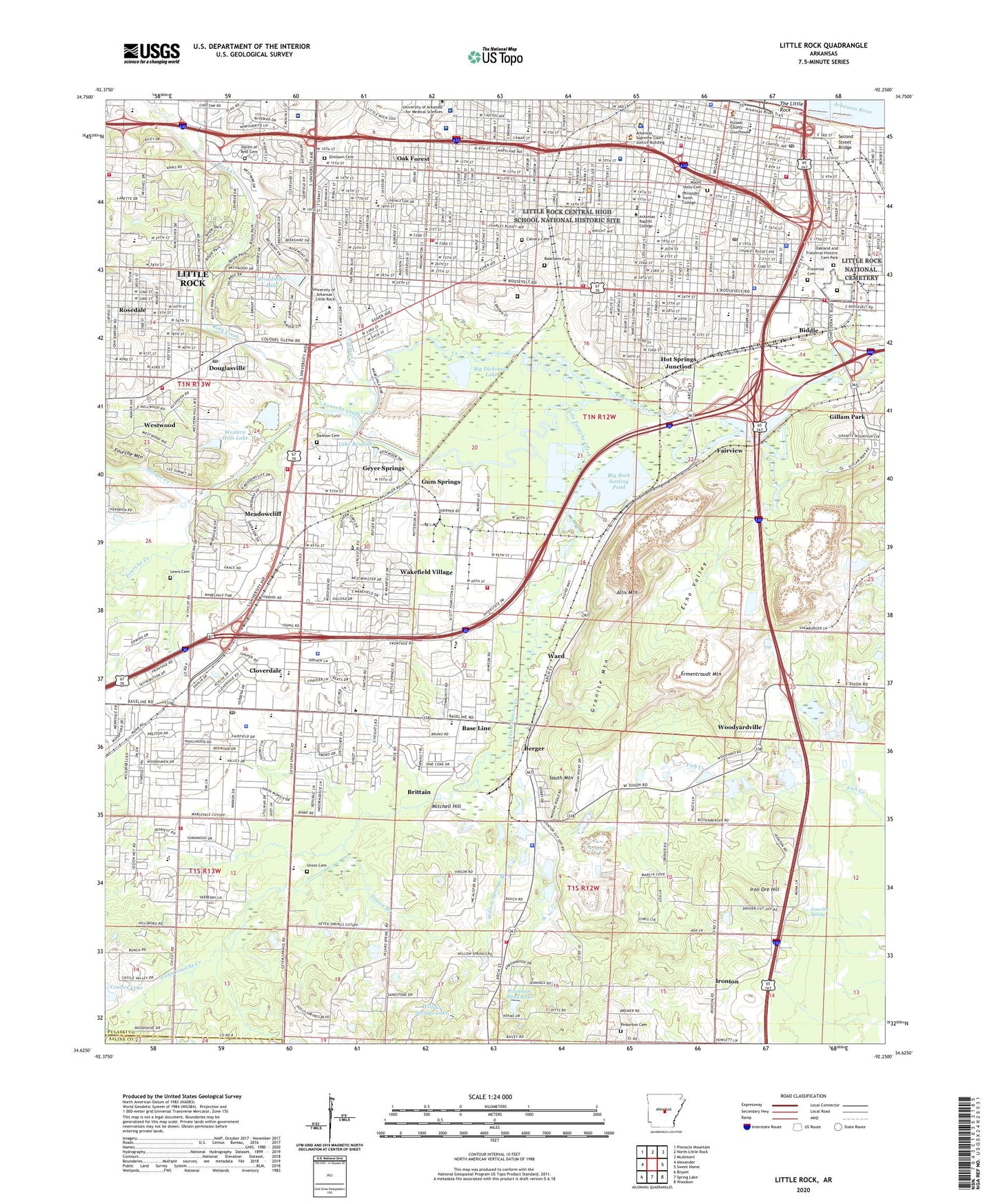
2024 topographic map quadrangle Little Rock in the state of Arkansas. Scale: 1:24000. Based on the newly updated USGS 7.5' US Topo map series, this map is in the following counties: Pulaski, Saline. The map contains contour data, water features, and other items you are used to seeing on USGS maps, but also has updated roads and other features. This is the next generation of topographic maps. Printed on high-quality waterproof paper with UV fade-resistant inks.
Quads adjacent to this one:
West: Alexander
Northwest: Pinnacle Mountain
North: North Little Rock
Northeast: McAlmont
East: Sweet Home
Southeast: Woodson
South: Spring Lake
Southwest: Bryant
This map covers the same area as the classic USGS quad with code o34092f3.
Contains the following named places: Allendale Manor, Allis Mountain, American Manor, Applegate, Arbor Cove, Arkansas Baptist College, Arkansas Childrens Hospital, Arkansas Childrens Hospital Heliport, Arkansas School for Deaf and Blind, Arkansas State Hospital, Azalea Place, Baptist Hospital, Barton Coliseum, Base Line, Baseline Academy, Baseline Baptist Day Care Center, Baseline-Chicot Shopping Center, Berger, Beverly Terrace, Biddle, Bierman Mine, Big Dickinson Lake, Big Rock Settling Pond, Big Rock Settling Pond Dam, Booker Junior High School, Booker T Washington School, Boyle Park, Brandon Centre Plaza Shopping Center, Brentwood Shopping Center, Brittain, Broadmoor Lake, Broadmoor Lake Dam, Broadmoor Shopping Center, Broadway Plaza Shopping Center, Brodie Creek, Brownwood Terrace, Calvary Cemetery, Capitol Hill School, Centennial School, Central Arkansas Christian Elementary School, Central Arkansas Veterans Healthcare System John L McClellan Memorial Veterans Hospital, Central Baptist Academy, Central High School, Christ Lutheran School, City of Little Rock, City of Little Rock Landfill, Cloverdale, Cloverdale Elementary School, Cloverdale Junior High School, Cloverdale Plaza Shopping Center, Cloverdale Shopping Center, Coleman Creek, Colony South Shopping Center, Coulter Lake, Coulter Lake Dam, Crossroads Shopping Center, Dawson Cemetery, Deer Meadow, Dixie Number 3 Mine, Doctors Hospital, Dollar Mine, Douglasville, Dunbar Junior College, Dunbar Junior High School, Dunbar Senior High School, East End Shopping Center, Echo Valley, Echo Valley Country Club, Elmlawn Cemetery, England Outcrop Mine, England Shaft Mine, Ermentraudt Mountain, Fairview, Fairview Baptist School, Fountain Head Lake, Four Seasons Shopping Center, Fourche Mountain, Fraternal Cemetery, Fuller Elementary School, Fuller Junior High School, Geyer South Shopping Center, Geyer Springs, Geyer Springs Shoppers Walk Shopping Center, Gillam Park, Gillam School, Good Counsel School, Gospel Assembly Academy, Governors Mansion Historic District, Granite Heights Park, Granite Mountain, Granite Mountain School, Guilford, Gulley Park, Gum Springs, Hall Plaza Shopping Center, Hangar Hill Park, Hastings Industrial Park, Haven of Rest Cemetery, Heckler Mine, Henderson Junior High School, Highland Park, Hindman Park, Hot Springs Junction, Industrial Plaza Shopping Center, Interstate Park, Iron Ore Hill, Iron Ore Spring, Ironton, Kanis Park, KGHT-AM (Sheridan), KITA-AM (Little Rock), KLRE-FM (Little Rock), Kramer School, La Petite Nursery School, Lake Bendine, Lamar-Porter Field, Lee School, Lewis Cemetery, Life Line Kindergarten, Little Fourche Creek, Little Rock, Little Rock Central High School National Historic Site, Little Rock Christian School, Little Rock National Cemetery, Longley School, MacArthur Park, Mainstreet Market Shopping Center, Mann Junior High School, Marshall Square Historic District, Martin Luther King Junior School, McArthur Park Historic District, McClellan High School, McClellan Place, McGuire Mine, Meadowcliff, Med-Flight Heliport, Merrivale, Metro Business Academy, Metrocentre Mall, Metropolitan High School, Metropolitan Vocational-Technical Center, Mills High School, Mitchell Hill, Mount Holly Cemetery, North England Mine, Oak Forest, Oak Forest Plaza Shopping Center, Oakland and Fraternal Historic Cemetery Park, Old Rauch Mine, Ottenheimer Park, Parkview High School, Penzel-Coe Mine, Pettaway Park, Pleasant Hill School, Ponderosa, Pulaski County Hospital, Quigley Stadium, Rauch Estate Open Pit Mine, Rauch Estate Shaft Mine, Rauch Extension Mine, Rauch Leased Mine, Rauch Mine, Rauch Property Mine, Reichardt Extension Mine, Reichardt Mine, Rock Creek, Rock Creek Golf Course, Rockefeller Elementary School, Rocky Mount School, Roosevelt Shopping Center, Roper School, Rosedale, Roselawn Cemetery, Rusty Pines, Saint Andrews School, Saint Edwards School, Saint Theresa School, Saint Vincent Doctors Hospital, Second Street Bridge, Shelly Shopping Center, Sixtyfifth Street Shopping Center, Skylark, South Heights Shopping Center, South Mountain, Southpark Shopping Center, Southwest Christian Academy, Southwest Junior High School, Southwest Mall Shopping Center, The Little Rock, Thom Park, Town and Country Estates, Town and Country Shopping Center, Township of Union, Twen Cen, Uams Heliport, Union Cemetery, University Mall Shopping Center, University of Arkansas for Medical Sciences Medical Center, University of Arkansas Law School, University Park, University Shopping Center, Village Shopping Center, Vinson Branch, Vocational School, Wakefield Park, Wakefield Shopping Center, Wakefield Village, War Memorial Park, War Memorial Stadium, Ward, Weiss Mine, West End Park, West Side Junior High School, Western Hills Country Club, Western Hills Lake, Western Hills Lake Dam, Westridge Country Club, Westwood, Whispering Pine Golf Course, Willow Springs Branch, Willow Springs Lake, Windamere, Windamere Corner Shopping Center, Windamere Plaza Shopping Center, Winder Field, Winn Mine, Wood Family Cemetery, Woodland Ridge, Woodyardville, Woolridge School, Worth James Airport, Yorkwood, ZIP Codes: 72201, 72204, 72209


