MyTopo
Alexander Arkansas US Topo Map
Couldn't load pickup availability
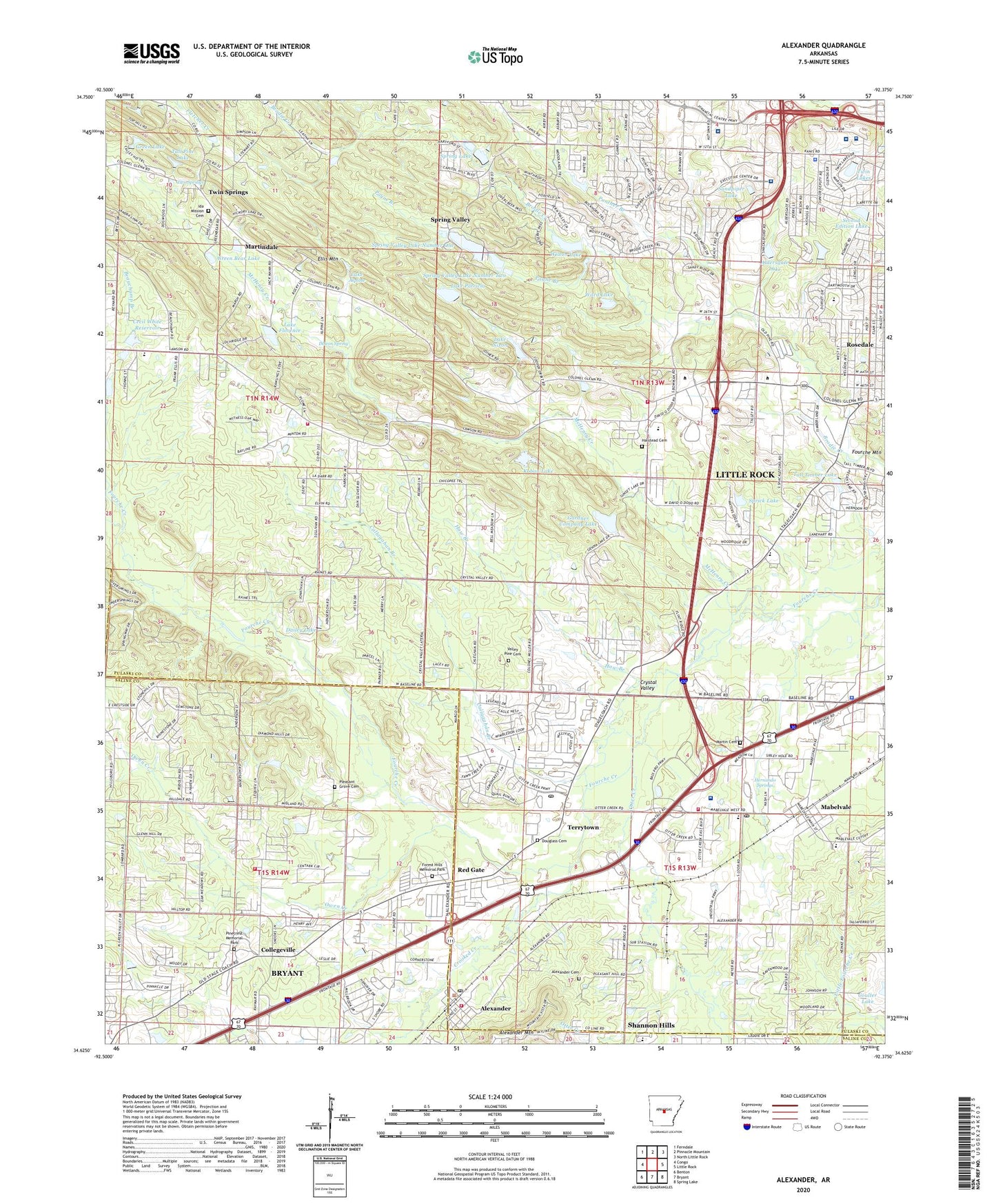
2024 topographic map quadrangle Alexander in the state of Arkansas. Scale: 1:24000. Based on the newly updated USGS 7.5' US Topo map series, this map is in the following counties: Pulaski, Saline. The map contains contour data, water features, and other items you are used to seeing on USGS maps, but also has updated roads and other features. This is the next generation of topographic maps. Printed on high-quality waterproof paper with UV fade-resistant inks.
Quads adjacent to this one:
West: Congo
Northwest: Ferndale
North: Pinnacle Mountain
Northeast: North Little Rock
East: Little Rock
Southeast: Spring Lake
South: Bryant
Southwest: Benton
This map covers the same area as the classic USGS quad with code o34092f4.
Contains the following named places: Aldersgate Camp, Aldersgate Lake, Aldersgate Lake Dam, Alexander, Alexander Cemetery, Alexander Fire Department Station 2, Alexander Police Department, Alexander Post Office, Allegiance Specialty Hospital of Little Rock, Alpine, Antioch Missionary Baptist Church, Arkansas Heart Hospital, Arkansas Highway Police Little Rock, Banks School, Banty, Baptist Health Extended Care Hospital, Baptist Health Rehabilitation Institute Hospital, Benton Speed Bowl, Bible Doctrine Church, Callagahan Branch, Calvary Christian Academy, Calvary Church of the Nazarene, Camp Marion, Cecil White Lake Dam, Cecil White Reservoir, Clarks Store, Collegeville, Collegeville Church of the Nazarene, Collegeville Volunteer Fire Department, Cook Lake, Cook Lake Dam, Crooked Creek, Crystal Fire Department Station 1, Crystal Fire Department Station 2, Crystal Hill Baptist Church, Crystal Valley, Dailey Lake, Dailey Lake Dam, David O Dodd Elementary School, Davis Elementary School, Deleon Spring, Department of Homeland Security United States Immigration and Customs Enforcement Little Rock, Dodd Elementary School, Douglas Corner, Douglass Cemetery, Drug Enforcement Administration, Ellis Mountain, Federal Bureau of Investigation Little Rock Field Division, First Missionary Baptist Church of Mabelvale, Florence Dam, Forest Hills Memorial Park, Gardner Company Lake, Gardner Company Lake Dam, Garrett Landing Strip, Green Bear Lake, Green Bear Lake Dam, Green Lake, Green Lake Dam, Green Memorial Baptist Church, Halstead Cemetery, Haw Branch, Heritage Baptist Temple, Heritage Christian School, Hernando Springs, Hilldale Church, Hunter United Methodist Church, Ida Mission Cemetery, J A Fair High School, Jack Ward Lake Dam, Kensington Place, Koban Lake, Koban Lake Dam, Labanah Baptist Church, Lake Alpine, Lake Florence, Lake Nixon, Lake Nixon Dam, Lake Patricia, Lake Patricia Dam, Lawson Elementary School, Little Oaks Park, Little Rock Fire Department Station 18, Little Rock Police Department Northwest Patrol Division, Lower Spring Lake, Lower Spring Lake Dam, Mabelvale, Mabelvale Church of Christ, Mabelvale Elementary School, Mabelvale Industrial Park, Mabelvale Junior High School, Mabelvale Middle School, Mabelvale Post Office, Mabelvale United Methodist Church, Martin Cemetery, Martindale, Martindale Baptist Church, Martindale Church, Martindale School, McHenry Creek, Missionary Baptist Seminary, Morehart Park, Mount Pleasant United Methodist Church, Mount Zion School, New Commandment Evangelistic Church, New Haven Church, New Life Church, Oak Park Church, Otter Creek, Otter Creek Assembly of God Church, Otter Creek Elementary School, Otter Creek First Baptist Church, Otter Creek Post Office, Owen Creek, Panther Branch, Panther Creek, Payne Branch, Pecan Lake, Perry Street Missionary Baptist Church, Pinecrest Memorial Park, Pinnacle Pointe Hospital, Plainview Church, Plainview School, Pleasant Grove Cemetery, Pleasant Valley Church, Quinn Chapel, Red Gate, River of Life Assembly of God Church, Rocky Valley Church, Romine Elementary School, Rose Hill Church, Salasco Sanitarium, Sandpiper Lake, Sandpiper Lake Dam, Sardis Road Missionary Baptist Church, Schaub School, Second Edition Lake, Second Edition Twin Lakes Dam, Sempercare Hospital Little Rock, Shannon Hills Fire Department Station 1, Shiloh, Southwest Regional Medical Center, Sprick Lake, Sprick Lake Dam, Spring Lake, Spring Lake Dam, Spring Lake Number One Dam, Spring Valley, Spring Valley Lake Number One, Spring Valley Lake Number Two, Spring Valley Lake Number Two Dam, State Youth Service Center, Tall Pine Lake, Tall Pine Lake Dam, Tall Timber Lake, Tall Timber Lake Dam, Tall Timbers West, Terrytown, The Church of Jesus Christ of Latter Day Saints, Timber Ridge, Township of Big Rock, Township of Brodie, Township of Ellis, Township of Fourche, Township of Owen, Trinity Church, Twin Lakes, Twin Lakes Dam, Twin Springs, Two Springs, Valley Pine Cemetery, Ward Lake, Westbrook, Westwood Missionary Baptist Church, Wilson Lake, Wilson Lake Dam, Zion Hill Church