MyTopo
Pinnacle Mountain Arkansas US Topo Map
Couldn't load pickup availability
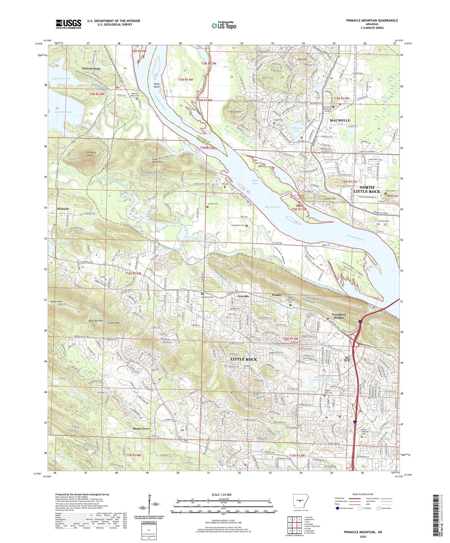
2024 topographic map quadrangle Pinnacle Mountain in the state of Arkansas. Scale: 1:24000. Based on the newly updated USGS 7.5' US Topo map series, this map is in the following counties: Pulaski, Faulkner. The map contains contour data, water features, and other items you are used to seeing on USGS maps, but also has updated roads and other features. This is the next generation of topographic maps. Printed on high-quality waterproof paper with UV fade-resistant inks.
Quads adjacent to this one:
West: Ferndale
Northwest: Fourche
North: Mayflower
Northeast: Cato
East: North Little Rock
Southeast: Little Rock
South: Alexander
Southwest: Congo
This map covers the same area as the classic USGS quad with code o34092g4.
Contains the following named places: Aaron Cemetery, Academic Plus Charter Schools, Agape Church, Annuciation Greek Orthodox Church, Arkansas Game and Fish Commission Law Enforcement Headquarters, Arkansas State Crime Laboratory, Asbury United Methodist Church, Ashley Square Shopping Center, Baker Elementary School, Bear Den Mountain, Bible Church of Little Rock, Breckenridge, Breckenridge Village Shopping Center, Brown School, Butler Park, Candlewood, Central Arkansas Christian School, Chambers Cemetery, Chenal Post Office, Christian Life Center, City of Maumelle, Colony West, Colony West Shopping Center, Cook Mountain, Crystal Hill, Crystal Mountain, Devoe Lake, Fellowship Bible Church, First Baptist Church, First Baptist Church of Maumelle, First Baptist Church of Pankey, Fulbright Elementary School, Fulk Mountains, Galleria Shopping Center, Grace Presbyterian Church, Grace Temple Church of God, Green Mountain Plaza Shopping Center, Grimmette Cemetery, Hickory Hills, Hickory Ridge, Highland School, Highland Valley United Methodist Church, Hillsborough, Ives Cemetery, Ivesville, KABF-FM (Little Rock), KAKI-FM (Benton), KARK-TV (Little Rock), KEZQ-FM (Jacksonville), KHLT-FM (Little Rock), King of Kings Evangelical Lutheran Church, Kirk Lake, Kirk Lake Dam, KKYK-FM (Little Rock), KLRT-TV (Little Rock), KMJX-FM (Conway), KSSN-FM (Little Rock), KTHV-TV (Little Rock), KUAR-FM (Little Rock), KZOU-FM (Little Rock), Lake Maumelle Dam, Lake Maumelle Volunteer Fire Department District 8 Station 2, Lake Valencia, Lake Valencia Dam, Lake Willastein Park, Little Maumelle River, Little Rock Fire Department Station 16, Little Rock Fire Department Station 20, Little Rock Fire Department Station 21, Little Rock Fire Department Station 9, Longlea, Market Street Plaza Shopping Center, Markham Plaza Shopping Center, Markham Street Baptist Church, Markham United Methodist Church, Marks Chapel, Marks Chapel United Methodist Church, Mason Cemetery, Maumelle, Maumelle Assembly of God Church, Maumelle Balloonport, Maumelle Country Club, Maumelle Fire Department Station 2, Maumelle Middle School, Maumelle Park, Maumelle Post Office, Maumelle Public Use Area, Maumelle River, Maumelle Station, McDermott Elementary School, Mesa View, Metropolitan Emergency Medical Service - Maumelle, Metropolitan Emergency Medical Service Little Rock Station 4, Mill Bayou, Montessori School, Mount View Church, Murray Lake, Natural Steps, Natural Steps Cemetery, Natural Steps Census Designated Place, North Hills Missionary Baptist Church, Old Forge Shopping Center, Palarm Creek, Pankey, Pankey Chapel, Parkway Place, Parkway Place Baptist Church, Parkway Place Presbyterian Church, Pebble Beach Park, Piedmont, Pilgrim Rest Church, Pilgrims Rest Cemetery, Pine Forest Elementary School, Pinnacle, Pinnacle Mountain, Pleasant Forest, Pleasant Hill Church, Pleasant Ridge, Pleasant School, Pleasant Valley, Pleasant Valley Church of Christ, Pleasant Valley Country Club, Pleasant Valley Country Club Lake, Pleasant Valley Estates, Pleasant View, Pride Valley Church, Pulaski Academy, Pulaski County Exceptional School, Pulaski County Farm, Rainwood, Rector Brake, Rector Chute, Rector Hill, Reids Bend, River Mountain Park, River Ridge Manor, Riverwood Memorial Gardens, Robinson School, Rock Creek, Rock Creek Square Plaza Shopping Center, Rocky Branch School, Rocky Mountain Cemetery, Saint Charles, Saint James United Methodist Church, Saint Paul Church, Saint Thomas, Secluded Hills, Second Presbyterian Church, Shackleford Plaza Shopping Center, Shady Grove, Shepherd Fold Church, Shinall Mountain, State Hospital Cemetery, Stuman Cemetery, Sturbridge Shopping Center, Sturgis Pond, Swan Lake, Swinton Cemetery, Taylor Chapel, Terry Elementary School, The Market Place Shopping Center, The Trellis Square Shopping Center, Three Rivers Airport, Township of Pyeatt, Turtle Creek, Unitarian Universalist Church, Unity Church, Valley Village Shopping Center, Village at Pleasant Valley Shopping Center, Walnut Valley Christian Academy, Walton Heights, West Chase Plaza Shopping Center, West Markham Shopping Center, Westside Post Office, White School, Willastein Lake, Willastein Lake Dam, Woodland Heights, Woodland Hills, Zion Chapel, ZIP Codes: 72113, 72211, 72212