MyTopo
Ozark Arkansas US Topo Map
Couldn't load pickup availability
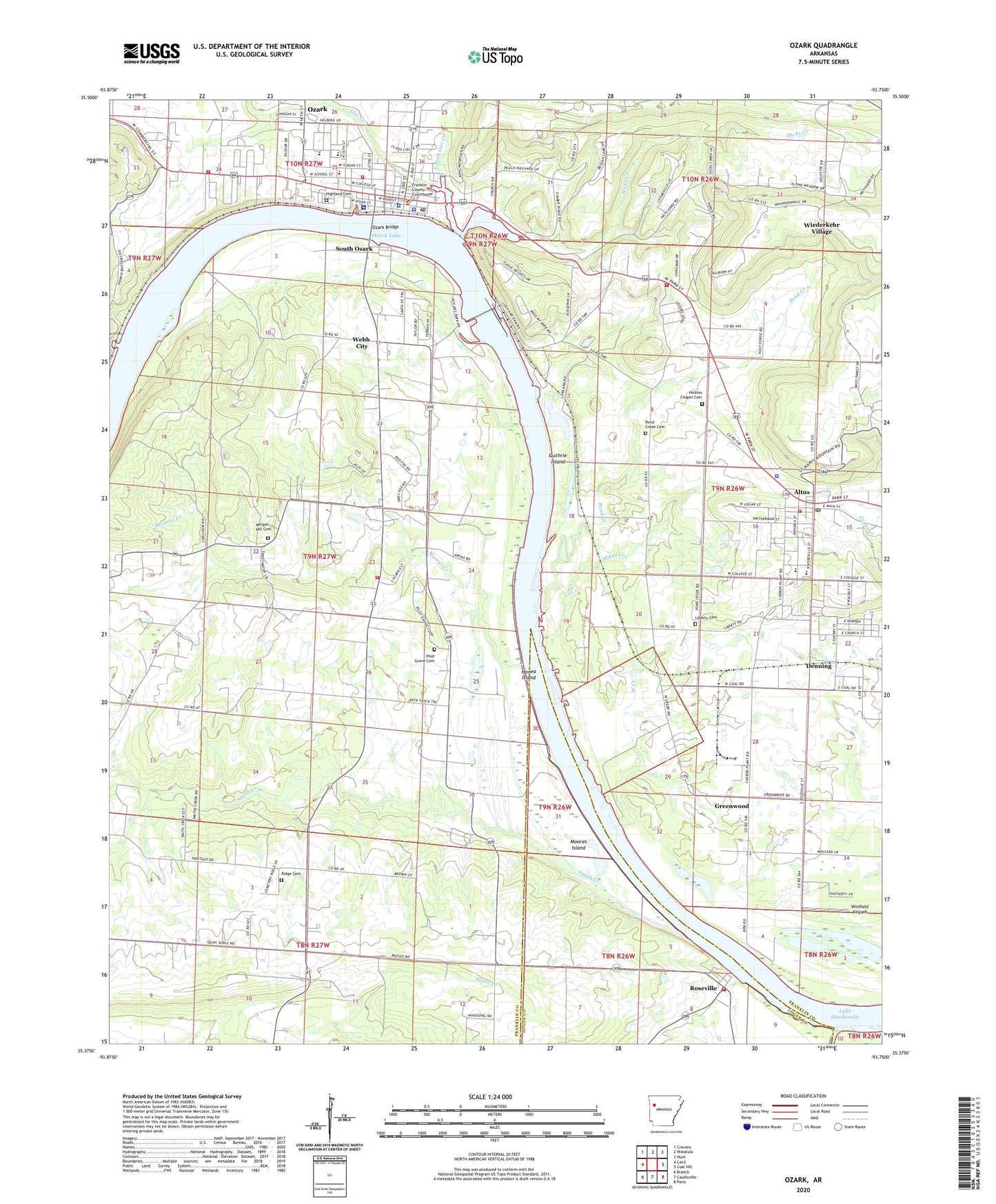
2024 topographic map quadrangle Ozark in the state of Arkansas. Scale: 1:24000. Based on the newly updated USGS 7.5' US Topo map series, this map is in the following counties: Franklin, Logan. The map contains contour data, water features, and other items you are used to seeing on USGS maps, but also has updated roads and other features. This is the next generation of topographic maps. Printed on high-quality waterproof paper with UV fade-resistant inks.
Quads adjacent to this one:
West: Cecil
Northwest: Cravens
North: Watalula
Northeast: Hunt
East: Coal Hill
Southeast: Paris
South: Caulksville
Southwest: Branch
This map covers the same area as the classic USGS quad with code o35093d7.
Contains the following named places: Abundant Life Fellowship Church, Aetna Gas Field, Altus, Altus - Denning Elementary School, Altus First Baptist Church, Altus Police Department, Altus Post Office, Altus Rural Fire Department, Altus United Methodist Church, Altus United Pentecostal Church, Altus Volunteer Fire Department, Altus-Denning High School, Arkansas Valley Vocational Technical Center, Aux Arc Park, City of Altus, City of Ozark, City of Wiederkehr Village, Corinth Church, Denning, Denning Post Office, Denning United Methodist Church, East Fork Gar Creek, East Side Park, Eastside Park, Elgin B Milton Elementary School, Faith Missionary Baptist Church, Franklin County Courthouse, Franklin County Emergency Medical Services, Franklin County Jail, Franklin County Sheriff's Office, Gar Creek, Greenwood, Guthrie Island, Hicks Creek, Highland Cemetery, Hills Chapel First Christian Church, Honea Island, KDYN-AM (Ozark), Liberty Cemetery, Mercy Hospital Turner Memorial, Mikes Creek, Moores Creek, Moores Island, Morgan Hill Cemetery, Nickles Chapel Cemetery, Ozark, Ozark Bridge, Ozark Elementary School, Ozark Gas Field, Ozark Junior High School, Ozark Kindergarten School, Ozark Middle School, Ozark Police Department, Ozark Post Office, Ozark Volunteer Fire Department Station 1, Ozark Volunteer Fire Department Station 2, Ozark-Jeta Taylor Lock and Dam, Pilot Grove Cemetery, Pond Creek, Pond Creek Cemetery, Reed Mountain Park, Ridge Cemetery, Roseville, Roseville Assembly of God Church, Roseville Baptist Church, Roseville Rural Fire Department Station 1, Roy Edgar McKee Memorial Chapel, Saint Marys Church, Smith Creek, South Ozark, South Ozark - Webb City Fire Department, Town of Denning, Township of Hogan, Township of Middle, Webb City, Webb City Baptist Church, Webb City School, West City Park, West Creek, West Creek Park, West Side Park, Wiederkehr Village, Winfield Airpark