MyTopo
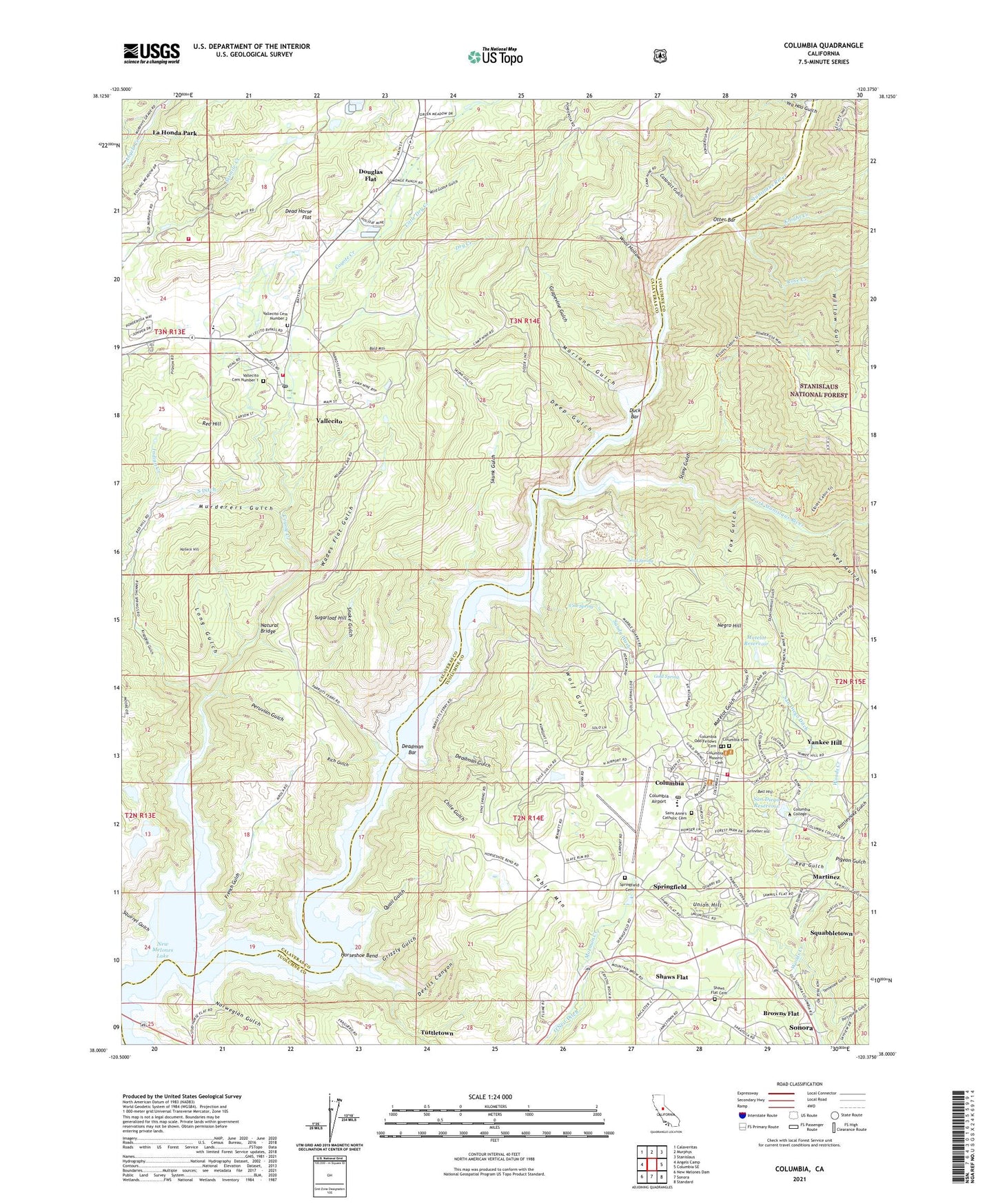
Columbia California US Topo Map
Couldn't load pickup availability
Also explore the Columbia Forest Service Topo of this same quad for updated USFS data
2021 topographic map quadrangle Columbia in the state of California. Scale: 1:24000. Based on the newly updated USGS 7.5' US Topo map series, this map is in the following counties: Calaveras, Tuolumne. The map contains contour data, water features, and other items you are used to seeing on USGS maps, but also has updated roads and other features. This is the next generation of topographic maps. Printed on high-quality waterproof paper with UV fade-resistant inks.
Quads adjacent to this one:
West: Angels Camp
Northwest: Calaveritas
North: Murphys
Northeast: Stanislaus
East: Columbia SE
Southeast: Standard
South: Sonora
Southwest: New Melones Dam
This map covers the same area as the classic USGS quad with code o38120a4.
Contains the following named places: American Camp Lookout, Bald Mountain, Bell Hill, Blue Mountain Quarry, Browns Flat, Carkeet Community Park, Carson Hill Mine, Cataract Gulch, Cataract Quarry, Cave Country, Chile Gulch, Claverie Building, Columbia, Columbia Airport, Columbia California Division of Forestry Air Attack Base, Columbia Cemetery, Columbia Census Designated Place, Columbia College, Columbia College Fire Department Station 79, Columbia College Library, Columbia Community College, Columbia Elementary School, Columbia Fire Protection District, Columbia Fire Station, Columbia Heliport, Columbia Historic District, Columbia Masonic Cemetery, Columbia Odd Fellows Cemetery, Columbia Post Office, Columbia State Historic Park, Columbia Village, Community Faith Center, Coyote Creek, Crystal Springs Mine, Cuesta Oaks, Dead Horse Flat, Deadman Bar, Deadman Gulch, Deep Gulch, Densmore Mine, Department of Forestry and Fire Protection Vallecito Camp, Devils Canyon, Douglas Flat, Douglas Flat School, Dry Creek, Duck Bar, Dutchess Mine, Elliots Cabin, Experimental Gulch, Experimental Mine, Ford Mine, Fox Gulch, Franklin and Wolfe Building, French Gulch, Gold Spring, Golden River Mine, Goodwin Ranch, Grapevine Gulch, Grizzly Gulch, Halleck Hill, Henning Mine, Hildebrand Building, Horseshoe Bend, J Levy Building, Kennebec Hill, Knapp Building, Knight Creek, Krappeau Gulch, La Honda Park, Leavitt and Walker Building, Little Dry Creek, Long Gulch, Lord Spring, Magendi Building, Marble Quarries, Marble Quarry, Mariane Gulch, Martinez, Masonic Hall, Matelot Gulch, Matelot Reservoir, McCarty Pit, McChesney and Mills Building, McChesney Building, Melones, Mississippi House, Miwok Cultural Center, Murderers Gulch, Murphys Fire Protection District Station 2, Murphys Wastewater 2024 Dam, Natural Bridge, Negro Hill, North Brainard Building, Norwegian Gulch, Otter Bar, Parrots Ferry Bridge, Parrotts Ferry, Peruvian Gulch, PHI Air Medical Sonora, Pigeon Gulch, Pine Log, Pioneer Park, Portuguese Gulch, Presbyterian Church of Columbia, Quail Gulch, Rattlesnake Gulch, Red Gulch, Red Hill, Republic Mine, Rich Gulch, Rose Creek, Saint Anne's Catholic Cemetery, Saint Annes Catholic Church, San Diego Ditch, San Diego Reservoir, San Diego Reservoir 1069 Dam, Sandy Wash, Saratoga Acres, Sawmill Flat, Sawmill Gulch, Schwartz Building, Shaws Flat, Shaws Flat Cemetery, Shaws Flat-Springfield Union School, Skunk Gulch, Snake Gulch, Soderer and Marshall Building, South Brainard Building, South Ditch, South Fork Stanislaus River, Springfield, Springfield Cemetery, Springfield Mine, Squabbletown, Squirrel Gulch, Stony Gulch, Sugarloaf Hill, Tennessee Gulch, Tuolumne Engine Company Number 1 Fire Station, Tuttletown Census Designated Place, Union Hill, Vallecito, Vallecito Cemetery Number 1, Vallecito Cemetery Number 2, Vallecito Census Designated Place, Vallecito High School, Vallecito Post Office, Vallecito State Historic Landmark, Vine Spring, Vine Spring Mine, Wades Flat Gulch, Wet Gulch, White Quarry, Wild Goose Gulch, Willow Gulch, Wolf Gulch, Wool Hollow, Yankee Hill, Yea Hoo Gulch, ZIP Codes: 95251, 95310