MyTopo
Sonora California US Topo Map
Couldn't load pickup availability
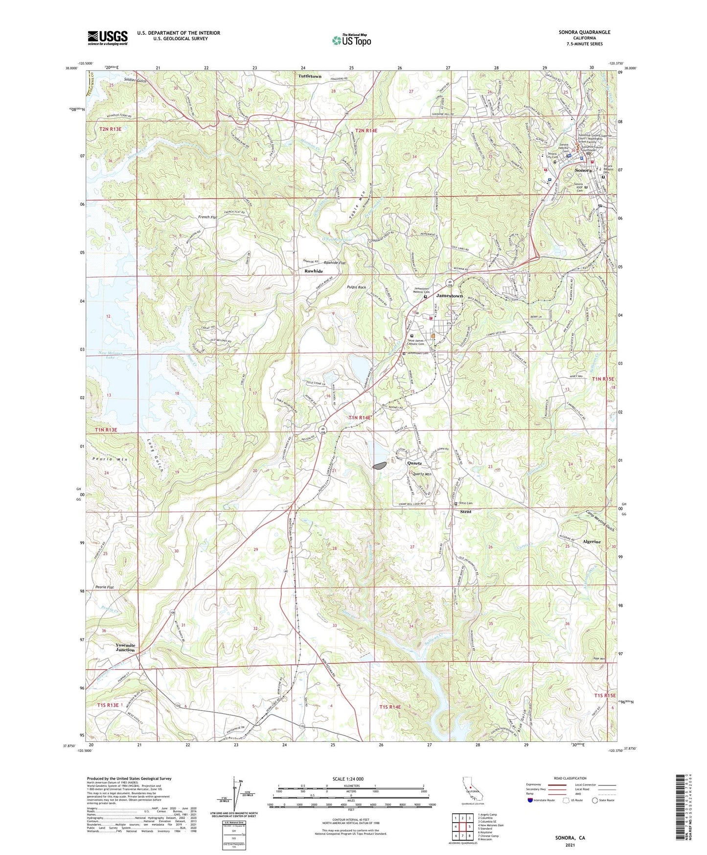
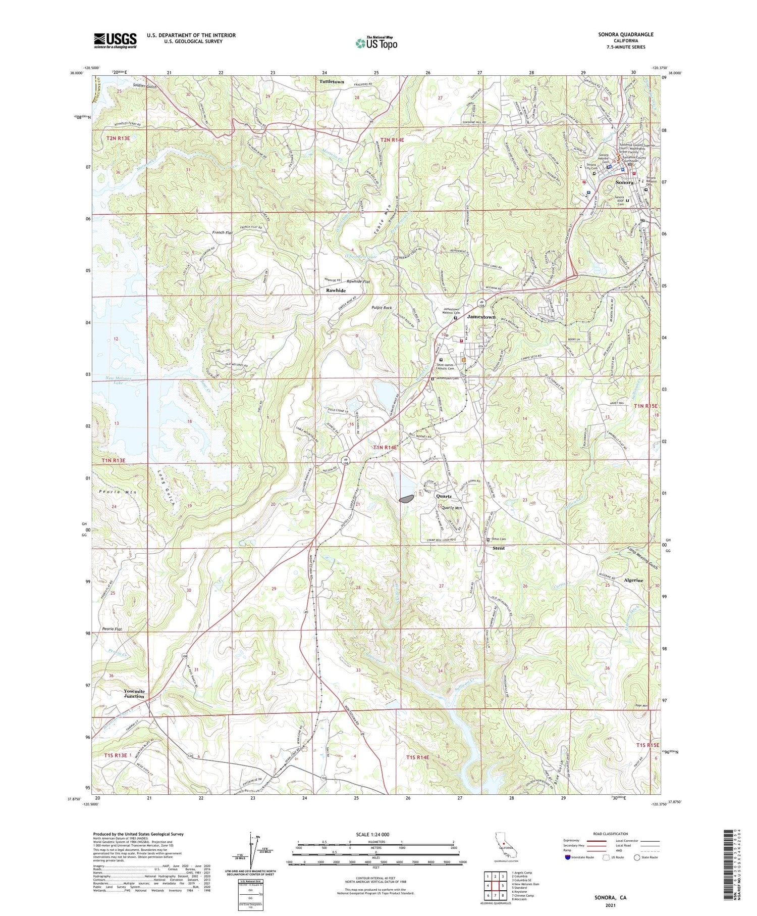
2021 topographic map quadrangle Sonora in the state of California. Scale: 1:24000. Based on the newly updated USGS 7.5' US Topo map series, this map is in the following counties: Tuolumne, Calaveras. The map contains contour data, water features, and other items you are used to seeing on USGS maps, but also has updated roads and other features. This is the next generation of topographic maps. Printed on high-quality waterproof paper with UV fade-resistant inks.
Quads adjacent to this one:
West: New Melones Dam
Northwest: Angels Camp
North: Columbia
Northeast: Columbia SE
East: Standard
Southeast: Moccasin
South: Chinese Camp
Southwest: Keystone
This map covers the same area as the classic USGS quad with code o37120h4.
Contains the following named places: Alabama Mine, Alameda Mine, Algerine, Algerine Creek, Anderson Mine, Anti-Chinese Mine, App Mine, Arbona Mine, Bear Creek, Belcher Mine, Bell Mine, Black Slate Mine, Bonanza Mine, California Highway Patrol Central Division - Sonora, Camp Meeting Gulch, Campo Seco, Cardinelle Mine, Chicken Ranch Rancheria, Chileno Mine, Chinese Station, City of Sonora, City of Sonora Fire Department, Climax Mine, Coffils Park, Crystalline Mine, Cuesta Serena, Curtis Creek, Dario Cassina High School, Defender Mine, Dickey Boy Mine, Downtown Sonora Post Office, Dragon Gulch, Dutch Mine, Erin-Go-Bragh Mine, Fairview Mine, Fairway Acres, French Flat, Gagnere Mine, Gibbs Ranch, Golden Gate Mine, Golden Rule Mine, Gray Eagle Mine, Habacker Mine, Harvard Mine, Heavenly Hills, Heslep Mine, Hess Mine, Hitchcock Mine, Humbug Mine, Jackass Hill, Jamestown, Jamestown Cemetery, Jamestown Census Designated Place, Jamestown Ditch, Jamestown Elementary School, Jamestown Masonic Cemetery, Jamestown Methodist Church, Jamestown Post Office, Jumper Mine, KTUO-FM (Sonora), KVML-AM (Sonora), KZSQ-FM (Sonora), Long Gulch, Mackey Prospect, Malone Prospect, Mapes-O'Hara Mine, Mark Twain Cabin, Marryatt Mine, Mazeppa Mine, Melones Sunset Lake Estates, Miller and Holmes Prospect, Montezuma, Morgan Mansion, Mother Lode Adventist Junior Academy, Mother Lode Fairgrounds, Mother Lode West, New Era Mine, New York Mine, Nugget Mine, Nyman Consolidated Mine, Omega Mine, O'Neil Ditch, O'Neil Reservoir, Page Mountain, Patterson Mine, Peoria Flat, Peppermint Creek, Perconi Ranch Prospect, Poverty Hill School, Pulpit Rock, Punch Bowl Mine, Quartz, Quartz 2019 Dam, Quartz Mountain, Quigg Prospect, Railtown 1897 State Historic Park, Rancho Sonora Estates, Rappahannock Mine, Rawhide, Rawhide Flat, Rawhide Mine, Rawhide School, Richards Prospect, Rolling Hills, Saint James Catholic Cemetery, Saint James Episcopal Church, Saint Patricks Catholic Church, San Giuseppe Mine, Santa Ysabel Consolidated Mine, Shaws Flat Ditch, Shore Mine, Sierra Hospital, Sims Prospect, Slate Creek, Soldier Gulch, Sonora, Sonora City Cemetery, Sonora City Hall, Sonora Creek, Sonora Division, Sonora Hebrew Cemetery, Sonora High School, Sonora IOOF Cemetery, Sonora Knolls, Sonora Masonic Cemetery, Sonora Police Department, Sonora Post Office, Sonora Regional Medical Center Transitional Care Unit, Sonora Sewer Farm, Sonora United Methodist Church, Stent, Stent Cemetery, Stent Census Designated Place, Stent Post Office, Sugg House, Sullivan and Kahl Prospect, Sullivan Creek, Sweeney Mine, Tarantula Mine, Toledo Mine, Tuolumne County Courthouse, Tuolumne County Fire Department Station 59 Sonora, Tuolumne County Fire Department Station 76 Jamestown Station, Tuolumne County Law Library, Tuolumne County Museum, Tuolumne County Sheriff's Office, Tuolumne General Hospital, Tuttletown, Vandelier Mine, Volponi Acres, Wickham Mine, Woods Creek Rotary Park, Woods Crossing, Yosemite Junction