MyTopo
Denair California US Topo Map
Couldn't load pickup availability
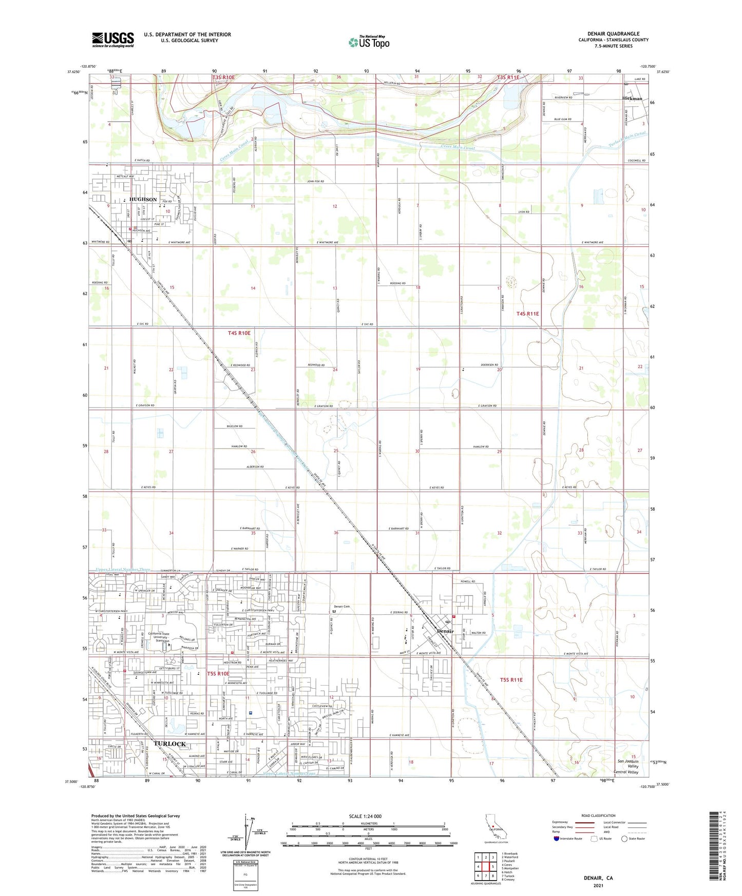
2021 topographic map quadrangle Denair in the state of California. Scale: 1:24000. Based on the newly updated USGS 7.5' US Topo map series, this map is in the following counties: Stanislaus. The map contains contour data, water features, and other items you are used to seeing on USGS maps, but also has updated roads and other features. This is the next generation of topographic maps. Printed on high-quality waterproof paper with UV fade-resistant inks.
Quads adjacent to this one:
West: Ceres
Northwest: Riverbank
North: Waterford
Northeast: Paulsell
East: Montpelier
Southeast: Cressey
South: Turlock
Southwest: Hatch
This map covers the same area as the classic USGS quad with code o37120e7.
Contains the following named places: Alberto Dairy, Berkeley Avenue Baptist Church, California State University - Stanislaus, Ceres Main Canal, Church of Christ, City of Hughson, City of Turlock, Crane Park, Crowell Elementary School, Denair, Denair Branch Stanislaus County Free Library, Denair Cemetery, Denair Census Designated Place, Denair Elementary School, Denair Fire Department, Denair High School, Denair Middle School, Denair Post Office, Donnely Park, Eastside Church of Christ, Emanuel Medical Center, Emanuel Medical Center Heliport, Emanuel Medical Center Library, Emilie J Ross Elementary School, Evangelical Free Church, Fairgrounds Substation, First Presbyterian Church, First United Methodist Church of Turlock, Foster Dairy Farms Number 3, Foster Dairy Farms Number 5, Foster Dairy Farms Number 6, Fox Grove Park, Geer Road Landfill, Geer Substation, Gratton Elementary School, Hickman, Hickman Census Designated Place, Hickman Post Office, Hughson, Hughson Branch Stanislaus County Free Library, Hughson City Hall, Hughson Elementary School, Hughson Fire Department, Hughson High School, Hughson Paramedic Ambulance Company, Hughson Post Office, Hughson Substation, KCSS-FM (Turlock), KMIX-FM (Turlock), Lebright School, Lowell School, Marvin A Dutcher Middle School, Merriam Drain, Montpelier Substation, North Side Assembly of God Church, Pentecostal Gospel Defenders Church, Pentecostal Pathfinders Church, Saint Francis Episcopal Church, Saint Thomas Assyrian-Chaldean Catholic Church, Seventh Day Adventist School, Stanislaus County Fairgrounds, Stanislaus County Sheriff's Office Denair, Stanislaus County Sheriff's Office Hughson Police Services, Stanislaus Library, Teague Park, Tuolumne Substation, Turlock Christian Schools, Turlock City Fire and Emergency Services Station 3, Turlock City Fire and Emergency Services Station 4, Turlock City Hall, Turlock Police Department, Turlock Rural Fire District, Turlock Shopping Center, Upper Lateral Number Three, Upper Lateral Number Two, Upper Lateral Number Two and One Half, Valley View Plaza Shopping Center, Walter M Brown Elementary School, War Memorial Auditorium, Word of Life Church, ZIP Codes: 95326, 95382