MyTopo
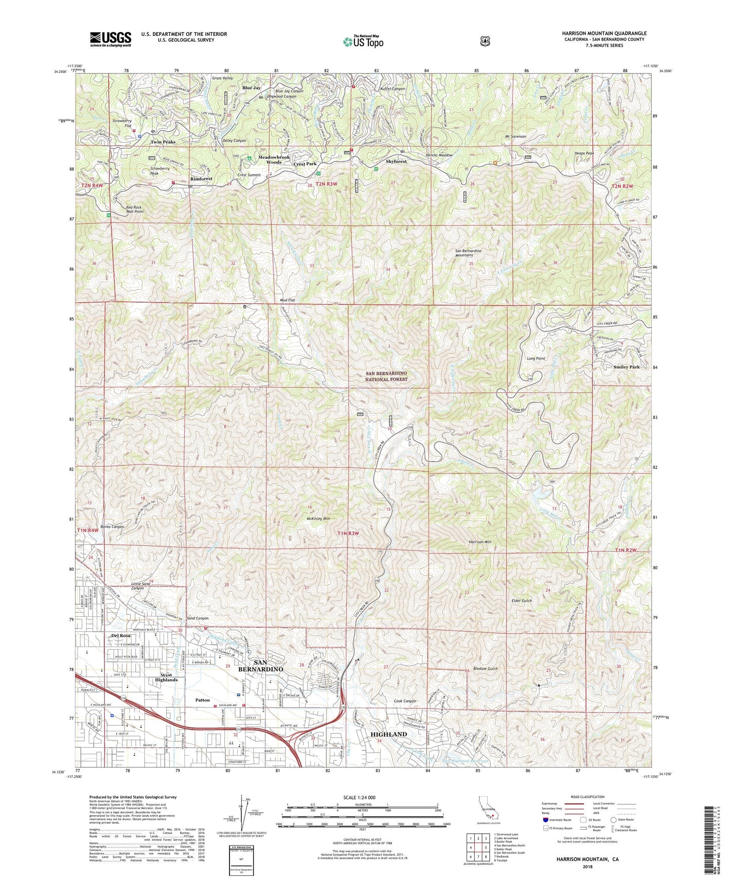
Harrison Mountain California US Topo Map
Couldn't load pickup availability
Also explore the Harrison Mountain Forest Service Topo of this same quad for updated USFS data
2021 topographic map quadrangle Harrison Mountain in the state of California. Scale: 1:24000. Based on the newly updated USGS 7.5' US Topo map series, this map is in the following counties: San Bernardino. The map contains contour data, water features, and other items you are used to seeing on USGS maps, but also has updated roads and other features. This is the next generation of topographic maps. Printed on high-quality waterproof paper with UV fade-resistant inks.
Quads adjacent to this one:
West: San Bernardino North
Northwest: Silverwood Lake
North: Lake Arrowhead
Northeast: Butler Peak
East: Keller Peak
Southeast: Yucaipa
South: Redlands
Southwest: San Bernardino South
Contains the following named places: Agua Fria, Allison Ranch, Amber Hills, Aquinius School, Arrowhead Ranger Station, Arrowhead Regional Medical Center - McKee Family Health Center, Barton Elementary School, Baylis Park Picnic Area, Belcher Park, Belvedere Elementary School, Blue Jay, Blue Jay Canyon, Blue Jay Post Office, Borea Canyon, City Creek Station, City Creek Truck Trail, Cook Canyon, Crest Forest Fire Protection District Station 6, Crest Park, Crest Summit, Daley Canyon, Daley Road Truck Trail, Del Rosa, Del Vallejo Middle School, Del Vallejo Park, Department of State Hospitals - Patton, Dogwood Campground, Dogwood Canyon, Dynamite Dam, East Fork City Creek, East Highland Reservoir, East Highlands 1800 Dam, Emmerton Elementary School, Fairview School, Fleming Creek, Fredalba, Fredalba Creek, Fredalba Post Office, Fredalba Spur, Fredalba Trail, Grace School, Harrison Mountain, Heaps Peak, Hencks Meadow, Highland, Highland - Pacific Elementary School, Highland Avenue Plaza Shopping Center, Highland Avenue School, Highland Canal, Highland Hills Church, Highland Pacific School, Highland Plaza Shopping Center, KBON-FM (Lake Arrowhead), KGGI-FM (Riverside), Kuffel Canyon, Lake Arrowhead, Lake Arrowhead Branch San Bernardino County Library, Little Bear Creek, Little Mill Creek, Little Sand Canyon, Little Sand Truck Trail, Long Point, Lutheran Church of Highland Avenue, McKinley Firebreak, McKinley Mountain, Meadowbrook Woods, MH15 Heaps Peak-US Forest Service Heliport, Molino, Mount Sorenson, Mountain High School, Mountain Shadows Plaza Shopping Center, Mountain View Christian School, Mud Flat, Oehl Elementary School, Patton, Patton Basin, Patton State Hospital Cemetery, Patton State Hospital Fire Department, Plunge Creek Truck Trail, Red Rock Wall Overlook, Red Rock Wall Point, Rim of the World Senior High School, Rimforest, Rimforest Post Office, San Andreas High School, San Bernardino City Fire Department Station 228, San Bernardino Community Church, San Bernardino Community Gardens, San Bernardino County Fire Department Station 26, San Bernardino County Fire Department Station 91 - Lake Arrowhead, San Bernardino County Sheriff's Office, San Bernardino National Forest Arrowhead Ranger Station Fire District, San Bernardino Police Department, San Gorgonio High School, San Manuel Fire Department, San Manuel Reservation, San Manuel Tribal Cemetery, Sand Canyon, Sand Canyon Dam, Santas Village, Schenk Creek, Serrano Middle School, Shepherds Flock Academy, Skyforest, Skyforest Post Office, Small Canyon 87 Dam, Smiley Park, Sterling Plaza Shopping Center, Sterling School, Strawberry Flat, Strawberry Peak, Switzer Park, Twin Peaks, Twin Peaks Post Office, West City Creek Truck Trail, West Fork City Creek, West Highlands, ZIP Codes: 92346, 92378, 92385, 92391