MyTopo
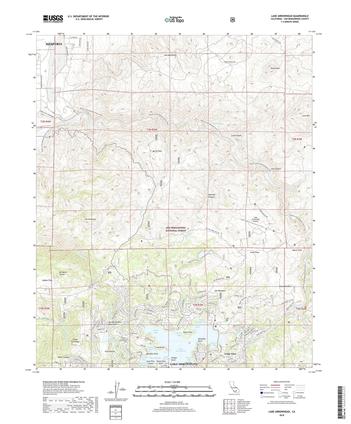
Lake Arrowhead California US Topo Map
Couldn't load pickup availability
Also explore the Lake Arrowhead Forest Service Topo of this same quad for updated USFS data
2021 topographic map quadrangle Lake Arrowhead in the state of California. Scale: 1:24000. Based on the newly updated USGS 7.5' US Topo map series, this map is in the following counties: San Bernardino. The map contains contour data, water features, and other items you are used to seeing on USGS maps, but also has updated roads and other features. This is the next generation of topographic maps. Printed on high-quality waterproof paper with UV fade-resistant inks.
Quads adjacent to this one:
West: Silverwood Lake
Northwest: Hesperia
North: Apple Valley South
Northeast: Fifteenmile Valley
East: Butler Peak
Southeast: Keller Peak
South: Harrison Mountain
Southwest: San Bernardino North
This map covers the same area as the classic USGS quad with code o34117c2.
Contains the following named places: Arrowhead Equestrian Estates, Ash Meadows, Bacon Flats, Blue Jay Bay, Bowen Ranch, Burnt Flats, Burnt Mill Creek, Calvary Chapel Christian School, Cedar Creek, Cedar Glen, Cedar Glen Post Office, Coxey Creek, Deep Creek, Deer Lodge Park, Eagle Point, Emerald Bay, Fern Creek, Grandview Elementary School, Grass Valley, Grass Valley 805-002 Dam, Grass Valley Lake, Holcomb Creek, Hooks Creek, Hot Spring, Kinley Creek, Lake Arrowhead, Lake Arrowhead 805 Dam, Lake Arrowhead Airport, Lake Arrowhead Census Designated Place, Lake Arrowhead Country Club, Lake Arrowhead Elementary School, Lake Arrowhead Post Office, Lake Arrowhead Scout Camps, Lake Arrowhead Village Shopping Center, Lion Canyon, Little Bear Creek, Lone Pine Island, Long Point, Luna Canyon, Luna Mountain, Maloney Canyon, Mary P Henck Intermediate School, Meadow Bay, Mojave Dam, Mojave River Camp, Mojave River Forks Reservoir, Mount Marie Louise, Mountains Community Hospital, Mountains Community Hospital Heliport, Mountaintop Academy, New Lake Arrowhead 1803-002 Dam, North Bay, North Shore, North Shore Campground, North Shore Marina, North Shore Ranger Station, Orchard Bay, Orchard Creek, Palisades Point, Papoose Lake, Paradise Bay, Rainbow Bay, Rainbow Point, Rock Camp Guard Station, Round Mountain, Rouse Meadow, Saddle Flats, San Bernardino County Fire Department Station 92 - Lake Arrowhead, San Bernardino County Fire Department Station 93 - Lake Arrowhead, San Bernardino County Fire Department Station 94 - Lake Arrowhead, Shake Creek, Shelter Cove, South Shore Marina, Squints Ranch, Stove Flats, Summit Valley, Tavern Bay, The Pinnacles, Toll Road Campground, Totem Pole Point, Tunnel Two Ridge, University of California Los Angeles Conference Center, Village Bay, Village Point, Warm Spring, West Fork Mojave River, Willow Creek, Willow Creek Jeep Trail, Winter Harbor Cove, Yacht Club Bay, ZIP Codes: 92321, 92352