MyTopo
Templeton California US Topo Map
Couldn't load pickup availability
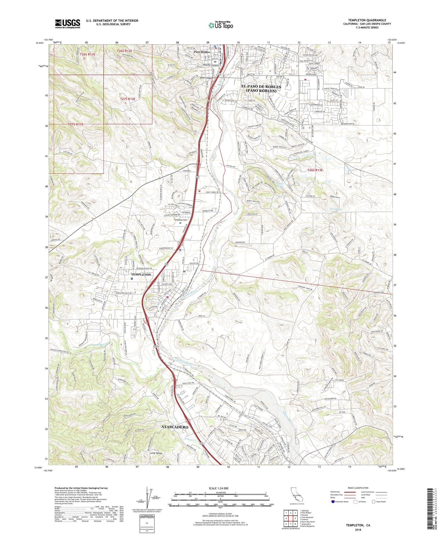
2021 topographic map quadrangle Templeton in the state of California. Scale: 1:24000. Based on the newly updated USGS 7.5' US Topo map series, this map is in the following counties: San Luis Obispo. The map contains contour data, water features, and other items you are used to seeing on USGS maps, but also has updated roads and other features. This is the next generation of topographic maps. Printed on high-quality waterproof paper with UV fade-resistant inks.
Quads adjacent to this one:
West: York Mountain
Northwest: Adelaida
North: Paso Robles
Northeast: Estrella
East: Creston
Southeast: Santa Margarita
South: Atascadero
Southwest: Morro Bay North
This map covers the same area as the classic USGS quad with code o35120e6.
Contains the following named places: Asuncion, Atascadero Creek, Bethel Lutheran Church, Bethel School, Bible Baptist Church, California Department of Forestry and Fire Protection Station 30 Paso Robles, California Highway Patrol Law Enforcement Templeton, Caso Robles Park, Centennial Park and Swimming Pool, Central Coast Church of Religious Science, Chicago Grade Landfill, Childrens House Montessori School, Church of the Good Shepherd, Creston Manor Vineyard and Winery, Cuesta College Extension, Daniel E Lewis Middle School, Del Rio Continuation High School, Dirtman Pit, Eagle Canyon High School, Eureka School, Fairview Farm Vineyard, First Missionary Baptist Church, First Presbyterian Church, First Southern Baptist Church, Graves Creek, Hope Farms Winery, Kiler Canyon, KVGR-AM (Templeton), KXER-AM (Templeton), Lake Ysabel, Liberty Continuation High School, Liberty High School, Melody Park, Neals Spring, New Covenant Church of God, Paso Robles Creek, Paso Robles Department of Emergency Services Fire Station 1 Main, Paso Robles Department of Emergency Services Fire Station 2 Sherwood, Paso Robles Golf and Country Club, Paso Robles High School, Paso Robles Police Department, Paso Robles Post Office, Pat Butler Elementary School, Peachy Canyon, Peoente Winery, Robbins Field Ball Park, Royal Oaks Park, San Benito Elementary School, San Luis Obispo County Sheriff's Office - North Station, Santa Lucia School, Santa Ysabel, Seventh Day Adventist Church, Sherwood Park, Sulphur Spring, Templeton, Templeton Athletic Fields, Templeton Cemetery, Templeton Census Designated Place, Templeton Community Services District Office, Templeton Elementary School, Templeton Fire Protection District, Templeton High School, Templeton Hills Christian School, Templeton Hills Seventh Day Adventist Church, Templeton Home School, Templeton Independent Study High School, Templeton Middle School, Templeton Post Office, The Church of Jesus Christ of Latter Day Saints, Trinity Lutheran Church, Trinity Lutheran School, True Spirit Baptist Church, Turtle Creek Park, Twin Cities Community Hospital, Twin Cities Community Hospital Heliport, Victory Chapel, Vineyard Elementary School, Virginia Peterson Elementary School, West Mall Alternative High School, Winifred Pifer Elementary School, ZIP Code: 93465