MyTopo
Watsonville West California US Topo Map
Couldn't load pickup availability
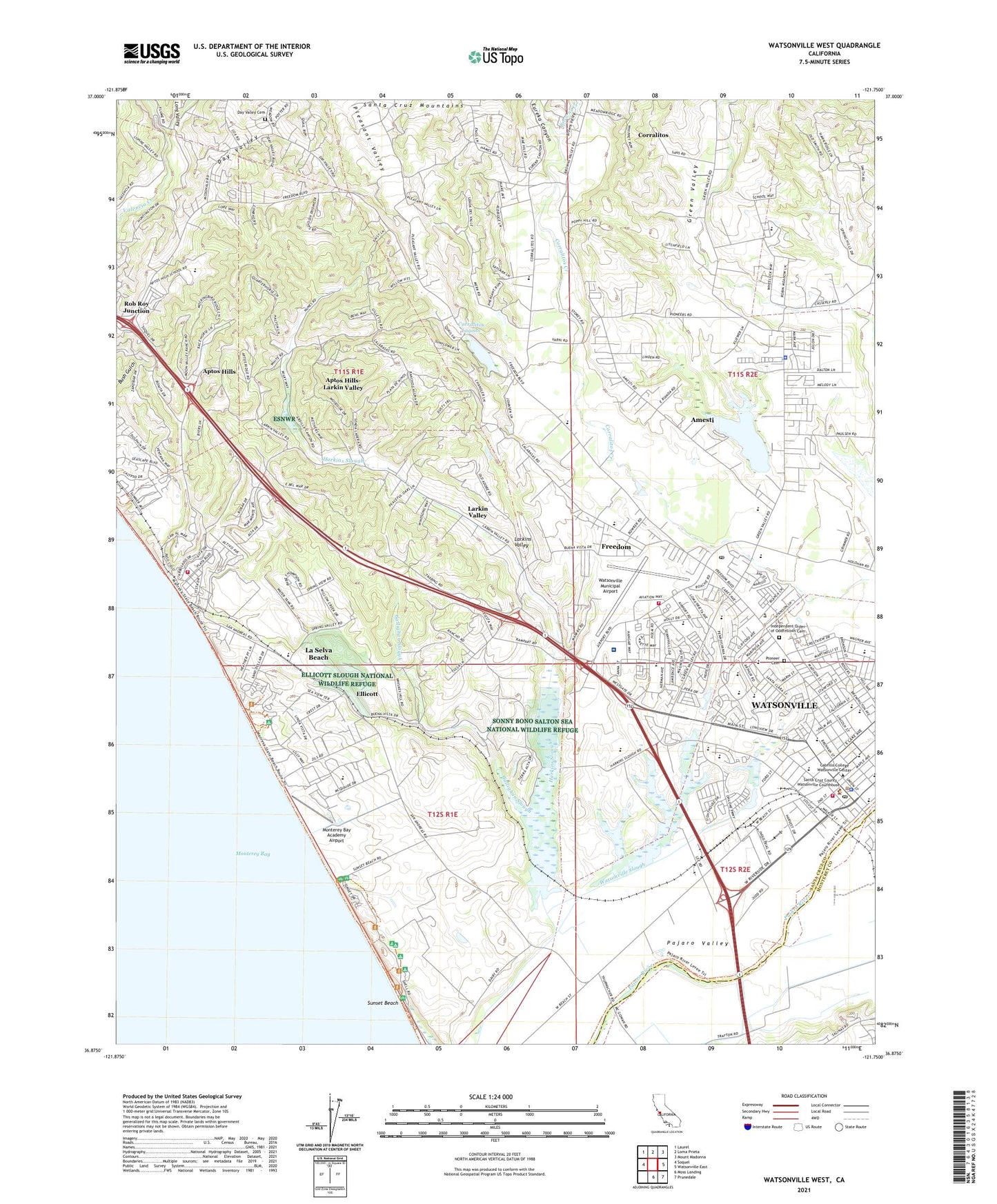
2021 topographic map quadrangle Watsonville West in the state of California. Scale: 1:24000. Based on the newly updated USGS 7.5' US Topo map series, this map is in the following counties: Santa Cruz, Monterey. The map contains contour data, water features, and other items you are used to seeing on USGS maps, but also has updated roads and other features. This is the next generation of topographic maps. Printed on high-quality waterproof paper with UV fade-resistant inks.
Quads adjacent to this one:
West: Soquel
Northwest: Laurel
North: Loma Prieta
Northeast: Mount Madonna
East: Watsonville East
Southeast: Prunedale
South: Moss Landing
This map covers the same area as the classic USGS quad with code o36121h7.
Contains the following named places: Academic Vocational Charter Institute, All Saints Episcopal Church, Alta Vista Heliport, Alta Vista Shopping Center, American Medical Response Ambulance Service, Amesti, Amesti Census Designated Place, Amesti Elementary School, Aptos, Aptos - La Selva Fire Protection District Station 3, Aptos High School, Aptos Hills, Aptos Hills-Larkin Valley Census Designated Place, Beach School, Bethel Tabernacle, Bolsa Del Pajaro, Bradley Elementary School, Browns Creek, Browns Valley, Buena Vista Landfill, Cabrillo Sand and Gravel Pit, Calabasas Elementary School, Calabasas School, California Highway Patrol Coastal Division - Santa Cruz, Callaghan Park, Camp McQuaide, Cesar Chavez Middle School, Chapel Hill United Presbyterian Church, Church of Christ, Church of God, Church of the Nazarene, City of Watsonville, Colache Town, Corralitos, Corralitos Census Designated Place, Corralitos Community Free Methodist Church, Corralitos Lagoon, Corralitos Union School, Crestview Park, Crestview Shopping Center, Day Valley, Day Valley Cemetery, Duncan Holbert School, E A Hall Middle School, El Cerrito Mobile Home Park, Ellicott, Ellicott Slough National Wildlife Refuge, Eureka Canyon, First Baptist Church, First Baptist Church of Freedom, First Christian Church, First Church of Christ Scientist, First Evangelical Lutheran Church, First Presbyterian Church, First United Methodist Church of Watsonville, Flodberg Park, Freedom, Freedom Branch Santa Cruz City-County Library, Freedom Census Designated Place, Freedom Center Shopping Center, Freedom Community United Methodist Church, Freedom Elementary School, Freedom Post Office, Fruitvale School, Full Gospel Mission Church, Gallighan Slough, Grace Baptist Church, Grace Temple, Green Valley, Green Valley Christian Center, Green Valley Christian School, Green Valley School, H A Hyde Elementary School, Hanson Slough, Harkins Slough, Hill School, Holy Eucharist Catholic Community Church, Iglesia Apostolica, Iglesia Metodista Unida de Pajaro, Iglesia Santa Pentecostes Templo, Independent Order of Oddfellows Cemetery, KOMY-AM (Watsonville), La Selva Beach, La Selva Beach Branch Satna Cruz City-County Library, La Selva Beach Census Designated Place, Laguna De Las Calabasas, Landmark Elementary School, Larkin Valley, Larkins Valley, Leonard, Linscott Charter School, Long Valley, Los Corralitos, MacQuiddy Elementary School, Manresa State Beach, Meadows Manor Mobile Home Park, Mesa Village Park, Mintie White Elementary School, Monte Vista Christian School, Monterey Bay Academy, Monterey Bay Academy Airport, Monterey Vista Mobile Home Park, Moreland Notre Dame School, Naval Auxiliary Air Station Watsonville, New School Community Day School, Nuga, Oakdale School, Ollason Grove, Pacific Coast Charter School, Pajaro Valley High School, Pine Hollow Campground, Pinto Lake, Pinto Lake City Park, Pinto Lake County Park, Pioneer Cemetery, Pleasant Valley, Pleasant Valley School, Port Watsonvile, Portola Heights Mobile Home Park, Presbyterian Hispanic New Church in America, Radcliff Elementary School, Ramsay Park, Renaissance High School, Roach School, Rob Roy Junction, Rolling Hills Middle School, Saint Patricks Roman Catholic Church, Saint Paul Baptist Church, San Andres, San Andres School, Santa Cruz County Court House Annex, Santa Cruz County Sheriff's Office South County Service Center, Santa Cruz County Sheriff's Office Watsonville, Santa Cruz Long-Toed Salamander Ecological Reserve, Scott County Park, Second Street Playground, Seventh Day Adventist Church, Solano Summit Academy, South Campground, Starlight Elementary School, Strongs Mobile Village, Struve Slough, Sunset Beach, Sunset Campground, Sunset State Beach, Sunset Wetland Natural Preserve, The Church of Jesus Christ of Latter Day Saints, The Glass House State Historic Landmark, Town and Country Shopping Center, Trinity Lutheran Church, Trinity Lutheran School, United Pentecostal Church, Veterans Memorial Building, Watsonville, Watsonville Auditorium, Watsonville Chamber of Commerce, Watsonville Community Hospital, Watsonville Community Hospital Heliport, Watsonville Division, Watsonville Fire Department Station 1, Watsonville Fire Department Station 2, Watsonville Grammar School, Watsonville Health Center, Watsonville High School, Watsonville Municipal Airport, Watsonville Plaza, Watsonville Police Department, Watsonville Post Office, Watsonville Public Library, Watsonville Square Shopping Center, Watsonville State Wildlife Area, Watsonville-Aptos Adult School, West Branch Struve Slough, West Spanish Seventh Day Adventist Church, Westview Presbyterian Church, William H Volck Museum, William H Volck Museum Library, ZIP Codes: 95019, 95076