MyTopo
Laurel California US Topo Map
Couldn't load pickup availability
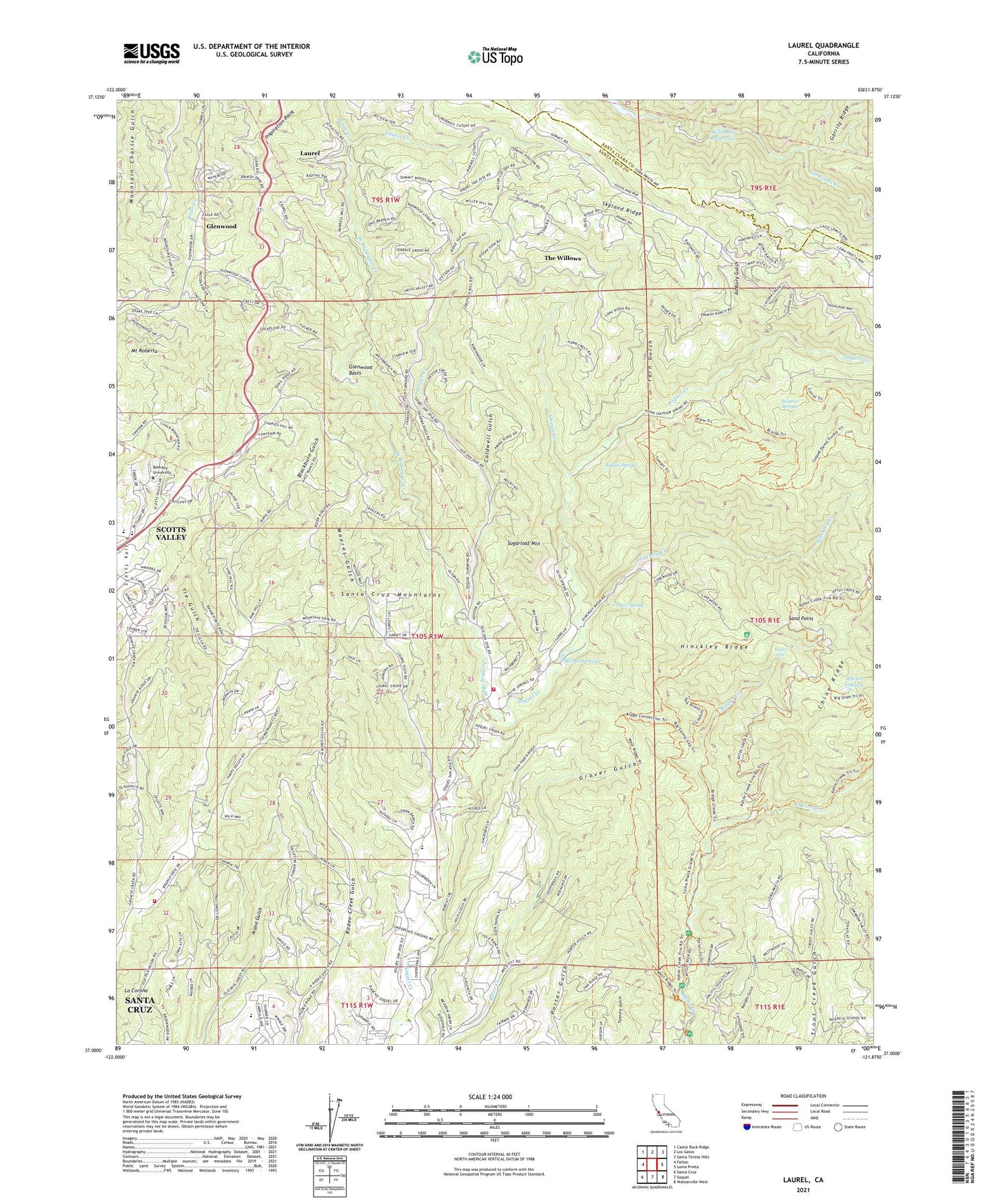
2021 topographic map quadrangle Laurel in the state of California. Scale: 1:24000. Based on the newly updated USGS 7.5' US Topo map series, this map is in the following counties: Santa Cruz, Santa Clara. The map contains contour data, water features, and other items you are used to seeing on USGS maps, but also has updated roads and other features. This is the next generation of topographic maps. Printed on high-quality waterproof paper with UV fade-resistant inks.
Quads adjacent to this one:
West: Felton
Northwest: Castle Rock Ridge
North: Los Gatos
Northeast: Santa Teresa Hills
East: Loma Prieta
Southeast: Watsonville West
South: Soquel
Southwest: Santa Cruz
This map covers the same area as the classic USGS quad with code o37121a8.
Contains the following named places: Amaya Creek, Aptos Creek Trail, Ashbury Gulch, Badger Spring, Bethany Park, Bethany University, Big Slide Trail, Big Stump Trail, Blackburn Gulch, Bottom of the Incline, Branciforte Fire Protection District, Bridge Creek, Bridge Creek Historic Site, Brush Lagoon, Burns Creek, Burrell Guard Station, Burrell School, Caldwell Gulch, Camp Comfort, Chaminade School, Charles Derby Small Bore Range, China Ridge, Clems, Crystal Creek, Fern Gulch, Fidel Ranch, Fontenay Villa, Garrity Ridge, Georges Picnic Area, Glenwood, Glenwood Basin, Glenwood School, Granite Creek, Grover Gulch, Halls Bridge, Happy Valley Church of Jesus Christ of Latter Day Saints, Happy Valley Conference Ground, Happy Valley Elementary School, Happy Valley School District Office, Hazelbrook School, Hester Creek, Hester Creek Church, Hester Creek School, Highland, Highland School, Hinckley Creek, Hinckley Ridge, Hoffman Historic Site, Inspiration Point, Kennolyn Camp, KFER-FM (Santa Cruz), La Corona, Laurel, Laurel Creek, Loma Prieta Church, Loma Prieta Mill, Lone Tree Prairie, Magnetic Spring, Maple Falls, Mary Easton Picnic Area, Mill Pond Trail, Millpond Lake, Moores Gulch, Mount Roberta, Mountain Bible Christian School, Mountain Elementary School, Mountain View Ranch, Olive Spring, Olive Springs, Olives Spring Quarry, Porter Family Picnic Area, Porter House, Porter Trail, Redwood Lodge, Saint Clare Retreat, Saint Marys Girls Camp, Sand Point, Sand Point Overlook, Santa Cruz Gardens Elementary School, Santas Village Shopping Center, Shoquel Augmentation, Skyland Ridge, Soquel Fire Department, Spanish Ranch, Sporup Sanitarium, Sugarloaf Mountain, Sulphur Springs, Summit Road Division, The Willows, Tie Gulch, Top of the Incline, Trout Gulch Trail, Tunnel Number 2, Vine Hill Elementary School, Vine Hill School, West Branch Soquel Creek, West Ridge Trail, West Ridge Trail Camp, Whites Lagoon, Williams 622-004 Dam, Williams Reservoir, ZIP Codes: 95003, 95065, 95073